Property Record
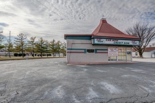
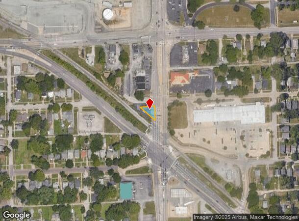
375 N 22Nd St, Decatur, IL 62521
This Property Is For Sale
NEARBY LISTINGS FOR SALE OR LEASE
Property Detail
375 N 22Nd St
Decatur, IL
Roach & Mcreynolds 1St Add
04-12-13-133-001
L 0022 B 00 ROACH & ~MCREYNOLDS 1ST ADD ~(EXC STATE ROAD) ~ IRREG ~
Vehiclerentalsvehiclesales
Macon
X
Illinois
17115C0310D
0.09 AC
2024
Springfield/Decatur
2024
Other Market Areas
001100
DEMOGRAPHICS near 375 N 22Nd St
1 Mile
3 Mile
5 Mile
2024 Total Population
7,925
48,062
79,309
2029 Population
7,820
47,293
77,380
Pop Growth 2024-2029
(1.32%)
(1.60%)
(2.43%)
Average Age
38
40
41
2024 Total Households
3,349
21,012
34,516
HH Growth 2024-2029
(1.40%)
(1.70%)
(2.52%)
Median Household Inc
$34,608
$39,226
$43,955
Avg Household Size
2.30
2.10
2.20
2024 Avg HH Vehicles
1.00
1.00
2.00
Median Home Value
$62,629
$78,026
$97,800
Median Year Built
1949
1956
1962
Nearby Places
Map Layers
Map Styles
 Street
 Aerial
- Restaurants
- Banks
- Shops
- Fitness
- Groceries
Nearby Properties
Address
Land Use
TOTAL SIZE
Lot Size
Zoning
Address
Land Use
TOTAL SIZE
Lot Size
Zoning
87.31 AC
MUNICIPAL
Address
Land Use
TOTAL SIZE
Lot Size
Zoning
107.54 AC
MUNICIPAL
Address
Land Use
TOTAL SIZE
Lot Size
Zoning
76.02 AC
MUNICIPAL
Address
Land Use
TOTAL SIZE
Lot Size
Zoning
68.23 AC
MUNICIPAL
Address
Land Use
TOTAL SIZE
Lot Size
Zoning
23.63 AC
MUNICIPAL
Address
Land Use
TOTAL SIZE
Lot Size
Zoning
1.03 AC
MUNICIPAL
Address
Land Use
TOTAL SIZE
Lot Size
Zoning
1.40 AC
MUNICIPAL
Address
Land Use
TOTAL SIZE
Lot Size
Zoning
6.60 AC
MUNICIPAL
Address
Land Use
TOTAL SIZE
Lot Size
Zoning
Address
Land Use
TOTAL SIZE
Lot Size
Zoning
6.68 AC
MUNICIPAL
Address
Land Use
TOTAL SIZE
Lot Size
Zoning
18.50 AC
MUNICIPAL
Address
Land Use
TOTAL SIZE
Lot Size
Zoning
6.89 AC
MUNICIPAL
Address
Land Use
TOTAL SIZE
Lot Size
Zoning
19.95 AC
MUNICIPAL
Address
Land Use
TOTAL SIZE
Lot Size
Zoning
7.82 AC
MUNICIPAL
Address
Land Use
TOTAL SIZE
Lot Size
Zoning
3.35 AC
MUNICIPAL
Address
Land Use
TOTAL SIZE
Lot Size
Zoning
25.59 AC
MUNICIPAL
Address
Land Use
TOTAL SIZE
Lot Size
Zoning
1.10 AC
MUNICIPAL
Address
Land Use
TOTAL SIZE
Lot Size
Zoning
78.13 AC
MUNICIPAL
Address
Land Use
TOTAL SIZE
Lot Size
Zoning
6.35 AC
MUNICIPAL
Address
Land Use
TOTAL SIZE
Lot Size
Zoning
3.93 AC
MUNICIPAL
Address
Land Use
TOTAL SIZE
Lot Size
Zoning
61.42 AC
MUNICIPAL
Address
Land Use
TOTAL SIZE
Lot Size
Zoning
54.49 AC
MUNICIPAL
Address
Land Use
TOTAL SIZE
Lot Size
Zoning
4.30 AC
MUNICIPAL
Address
Land Use
TOTAL SIZE
Lot Size
Zoning
9.53 AC
MUNICIPAL
Address
Land Use
TOTAL SIZE
Lot Size
Zoning
35.07 AC
MUNICIPAL
Address
Land Use
TOTAL SIZE
Lot Size
Zoning
14.73 AC
MUNICIPAL
Address
Land Use
TOTAL SIZE
Lot Size
Zoning
0.97 AC
MUNICIPAL
Address
Land Use
TOTAL SIZE
Lot Size
Zoning
3.50 AC
MUNICIPAL
The World's #1 Commercial Real Estate Marketplace
Connect with us
© 2025 CoStar Group
The information above has been obtained from sources believed reliable. While we do not doubt its accuracy we have not verified it and make no guarantee, warranty or representation about it. It is your responsibility to independently confirm its accuracy and completeness. Any projections, opinions, assumptions, or estimates used are for example only and do not represent the current or future performance of the property. The value of this transaction to you depends on tax and other factors which should be evaluated by your tax, financial, and legal advisors. You and your advisors should conduct a careful, independent investigation of the property to determine to your satisfaction the suitability of the property for your needs.