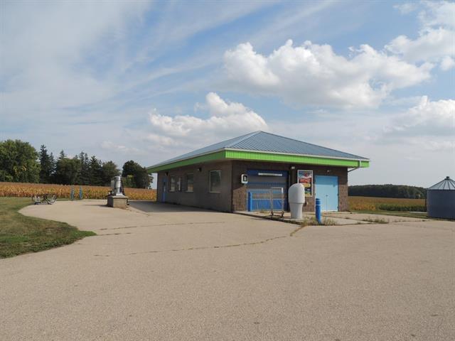
Property Record
375 S Main St, Iola, WI 54945

Property Detail
375 S Main St
Other Market Areas
SEC35 T25N R14E PRT NWNE DAF LT2 CSM V27P138 V583P15 EX V821P859 V820P105 .457A
30-35-12-9
WAUPACA
Commercialnec
Wisconsin
B and X Area of moderate flood hazard, usually the area between the limits of the 100-year and 500-year floods.
2
2023
0.46 AC
2024
Wisconsin North Area
100300
NEARBY LISTINGS FOR SALE OR LEASE
-
-
View all Iola listings for sale on LoopNet.com
DEMOGRAPHICS near 375 S Main St
1 mile
3 mile
5 mile
2025 Total Population
1,069
5,237
6,147
2030 Population
1,051
5,141
6,011
Pop Growth 2025-2030
(1.68%)
(1.83%)
(2.21%)
Average Age
41
42
42
2025 Total Households
490
2,346
2,705
HH Growth 2025-2030
(2.04%)
(1.92%)
(2.29%)
Median Household Inc
$28,963
$59,872
$61,138
Avg Household Size
2.10
2.20
2.20
2025 Avg HH Vehicles
2.00
2.00
2.00
Median Home Value
$134,166
$141,695
$151,721
Median Year Built
1981
1967
1968
Nearby Places
Map Layers
Map Styles
 Street
 Aerial
Transit
 Traffic
 Biking
Places
Listings with unknown addresses are not visible on the map
- Restaurants
- Banks
- Shops
- Fitness
- Groceries
PUBLIC TRANSPORTATION
AIRPORT
Appleton International
Drive
Walk
Distance
Appleton International
51 min
33.4 mi
Green Bay/Austin Straubel International
Drive
Walk
Distance
Green Bay/Austin Straubel International
72 min
45.0 mi
SALE & LEASE HISTORY
LISTING DATE
SALE/LEASE

Dec 27, 2023
For Sale
Nearby Properties
Address
Land Use
TOTAL SIZE
Lot Size
Zoning
Address
Land Use
TOTAL SIZE
Lot Size
Zoning
19.95 AC
Address
Land Use
TOTAL SIZE
Lot Size
Zoning
Address
Land Use
TOTAL SIZE
Lot Size
Zoning
76,264 SF
6.27 AC
Address
Land Use
TOTAL SIZE
Lot Size
Zoning
30,128 SF
11.23 AC
Address
Land Use
TOTAL SIZE
Lot Size
Zoning
24,334 SF
22.62 AC
Address
Land Use
TOTAL SIZE
Lot Size
Zoning
40,661 SF
5.40 AC
Address
Land Use
TOTAL SIZE
Lot Size
Zoning
7.53 AC
Address
Land Use
TOTAL SIZE
Lot Size
Zoning
14.02 AC
Address
Land Use
TOTAL SIZE
Lot Size
Zoning
5,799 SF
2.50 AC
Address
Land Use
TOTAL SIZE
Lot Size
Zoning
20,876 SF
4.40 AC
Address
Land Use
TOTAL SIZE
Lot Size
Zoning
Address
Land Use
TOTAL SIZE
Lot Size
Zoning
16,580 SF
7.28 AC
Address
Land Use
TOTAL SIZE
Lot Size
Zoning
46,080 SF
3.39 AC
Address
Land Use
TOTAL SIZE
Lot Size
Zoning
29,670 SF
3.37 AC
Address
Land Use
TOTAL SIZE
Lot Size
Zoning
7.16 AC
Address
Land Use
TOTAL SIZE
Lot Size
Zoning
Address
Land Use
TOTAL SIZE
Lot Size
Zoning
9.52 AC
Address
Land Use
TOTAL SIZE
Lot Size
Zoning
33.22 AC
Address
Land Use
TOTAL SIZE
Lot Size
Zoning
13,650 SF
1.30 AC
Address
Land Use
TOTAL SIZE
Lot Size
Zoning
Address
Land Use
TOTAL SIZE
Lot Size
Zoning
14,348 SF
0.52 AC
Address
Land Use
TOTAL SIZE
Lot Size
Zoning
50,610 SF
8.52 AC
Address
Land Use
TOTAL SIZE
Lot Size
Zoning
21,618 SF
4.06 AC
Address
Land Use
TOTAL SIZE
Lot Size
Zoning
9.84 AC
Address
Land Use
TOTAL SIZE
Lot Size
Zoning
8,601 SF
1.77 AC
Address
Land Use
TOTAL SIZE
Lot Size
Zoning
Address
Land Use
TOTAL SIZE
Lot Size
Zoning
55.32 AC
Address
Land Use
TOTAL SIZE
Lot Size
Zoning
9,108 SF
97.07 AC
A-G
Address
Land Use
TOTAL SIZE
Lot Size
Zoning
0.17 AC
Address
Land Use
TOTAL SIZE
Lot Size
Zoning
6.38 AC
The World's #1 Commercial Real Estate Marketplace
Connect with us
© 2026 CoStar Group
The information above has been obtained from sources believed reliable. While we do not doubt its accuracy we have not verified it and make no guarantee, warranty or representation about it. It is your responsibility to independently confirm its accuracy and completeness. Any projections, opinions, assumptions, or estimates used are for example only and do not represent the current or future performance of the property. The value of this transaction to you depends on tax and other factors which should be evaluated by your tax, financial, and legal advisors. You and your advisors should conduct a careful, independent investigation of the property to determine to your satisfaction the suitability of the property for your needs.