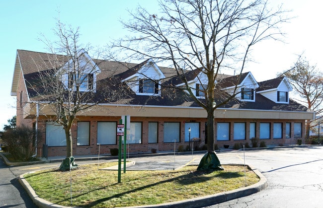
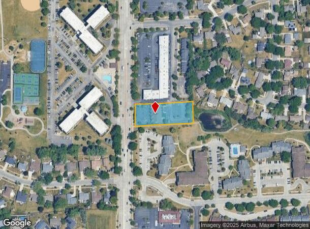
Property Record
375 S Roselle Rd, Schaumburg, IL 60193


NEARBY LISTINGS FOR SALE OR LEASE
Property Detail
375 S Roselle Rd
Chicago-Naperville-Elgin, IL-IN-WI
Resubdivision Of Lt2166 In Lancer 21 U
07-22-406-038-0000
(RESUBDIVISION) OF LT2166 IN LANCER 21 UNIT2 SUB OF P T OF SW SE SEC 22-41-10
Storebuilding
Cook
X
Illinois
17031C0189J
2166
2023
1 AC
2024
Schaumburg Area
804611
Chicago
10,966 SF
DEMOGRAPHICS near 375 S Roselle Rd
1 Mile
3 Mile
5 Mile
2024 Total Population
15,695
109,427
255,624
2029 Population
15,259
106,036
247,769
Pop Growth 2024-2029
(2.78%)
(3.10%)
(3.07%)
Average Age
44
41
41
2024 Total Households
5,750
40,672
95,313
HH Growth 2024-2029
(3.11%)
(3.40%)
(3.37%)
Median Household Inc
$87,413
$91,858
$87,884
Avg Household Size
2.50
2.60
2.60
2024 Avg HH Vehicles
2.00
2.00
2.00
Median Home Value
$331,206
$314,177
$285,974
Median Year Built
1976
1976
1976
Nearby Places
Map Layers
Map Styles
 Street
 Aerial
- Restaurants
- Banks
- Shops
- Fitness
- Groceries
PUBLIC TRANSPORTATION
COMMUTER RAIL
Roselle Station (Milwaukee District West Line - Northeast Illinois Regional Commuter Railroad (Metra))
DRIVE
WALK
Distance
Roselle Station (Milwaukee District West Line - Northeast Illinois Regional Commuter Railroad (Metra))
9 min
3.7 mi
Schaumburg Station (Milwaukee District West Line - Northeast Illinois Regional Commuter Railroad (Metra))
DRIVE
WALK
Distance
Schaumburg Station (Milwaukee District West Line - Northeast Illinois Regional Commuter Railroad (Metra))
10 min
4.6 mi
AIRPORT
Chicago O'Hare International
DRIVE
WALK
Distance
Chicago O'Hare International
41 min
14.7 mi
Chicago Midway International
DRIVE
WALK
Distance
Chicago Midway International
53 min
30.1 mi
Nearby Properties
Address
Land Use
TOTAL SIZE
Lot Size
Zoning
Address
Land Use
TOTAL SIZE
Lot Size
Zoning
42.14 AC
Address
Land Use
TOTAL SIZE
Lot Size
Zoning
Address
Land Use
TOTAL SIZE
Lot Size
Zoning
Address
Land Use
TOTAL SIZE
Lot Size
Zoning
782,746 SF
12.44 AC
Address
Land Use
TOTAL SIZE
Lot Size
Zoning
300,000 SF
9.29 AC
Address
Land Use
TOTAL SIZE
Lot Size
Zoning
875,776 SF
8.73 AC
Address
Land Use
TOTAL SIZE
Lot Size
Zoning
489,153 SF
18.90 AC
I
Address
Land Use
TOTAL SIZE
Lot Size
Zoning
12.66 AC
Address
Land Use
TOTAL SIZE
Lot Size
Zoning
748,059 SF
7.36 AC
Address
Land Use
TOTAL SIZE
Lot Size
Zoning
388,080 SF
12.64 AC
Address
Land Use
TOTAL SIZE
Lot Size
Zoning
345,881 SF
12.66 AC
I
Address
Land Use
TOTAL SIZE
Lot Size
Zoning
Address
Land Use
TOTAL SIZE
Lot Size
Zoning
24.55 AC
Address
Land Use
TOTAL SIZE
Lot Size
Zoning
101,282 SF
2.34 AC
Address
Land Use
TOTAL SIZE
Lot Size
Zoning
239,700 SF
Address
Land Use
TOTAL SIZE
Lot Size
Zoning
346,165 SF
3.15 AC
Address
Land Use
TOTAL SIZE
Lot Size
Zoning
290,000 SF
9.08 AC
Address
Land Use
TOTAL SIZE
Lot Size
Zoning
375,417 SF
13.35 AC
Address
Land Use
TOTAL SIZE
Lot Size
Zoning
302,135 SF
19.28 AC
Address
Land Use
TOTAL SIZE
Lot Size
Zoning
Address
Land Use
TOTAL SIZE
Lot Size
Zoning
161,514 SF
11.17 AC
Address
Land Use
TOTAL SIZE
Lot Size
Zoning
338,694 SF
12.18 AC
Address
Land Use
TOTAL SIZE
Lot Size
Zoning
94,823 SF
8.97 AC
Address
Land Use
TOTAL SIZE
Lot Size
Zoning
220,514 SF
14.76 AC
I
Address
Land Use
TOTAL SIZE
Lot Size
Zoning
133,712 SF
16.65 AC
Address
Land Use
TOTAL SIZE
Lot Size
Zoning
357,241 SF
25.69 AC
Address
Land Use
TOTAL SIZE
Lot Size
Zoning
108,890 SF
10.04 AC
Address
Land Use
TOTAL SIZE
Lot Size
Zoning
28,913 SF
6.63 AC
Address
Land Use
TOTAL SIZE
Lot Size
Zoning
196,866 SF
9.77 AC
I
Address
Land Use
TOTAL SIZE
Lot Size
Zoning
93,333 SF
22.45 AC
The World's #1 Commercial Real Estate Marketplace
Connect with us
© 2025 CoStar Group
The information above has been obtained from sources believed reliable. While we do not doubt its accuracy we have not verified it and make no guarantee, warranty or representation about it. It is your responsibility to independently confirm its accuracy and completeness. Any projections, opinions, assumptions, or estimates used are for example only and do not represent the current or future performance of the property. The value of this transaction to you depends on tax and other factors which should be evaluated by your tax, financial, and legal advisors. You and your advisors should conduct a careful, independent investigation of the property to determine to your satisfaction the suitability of the property for your needs.