Property Record
375 Sw Zobrist St, Estacada, OR 97023
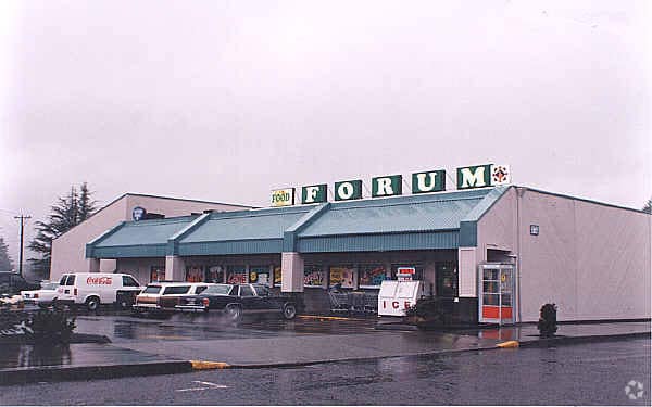

Property Detail
375 Sw Zobrist St
Portland-Vancouver-Hillsboro, OR-WA
148 ESTACADA LTS 1, 11-16 BLK 5 ALSO VAC ALLEY
00948693
Clackamas
Commercialbuilding
Oregon
D
1,11
B and X Area of moderate flood hazard, usually the area between the limits of the 100-year and 500-year floods.
0.71 AC
2025
SE Outlying
2025
Portland
024200
NEARBY LISTINGS FOR SALE OR LEASE
-
-
View all Estacada listings for sale on LoopNet.com
DEMOGRAPHICS near 375 Sw Zobrist St
1 mile
3 mile
5 mile
2025 Total Population
4,391
9,396
13,801
2030 Population
4,501
9,534
13,823
Pop Growth 2025-2030
+ 2.51%
+ 1.47%
+ 0.16%
Average Age
40
41
43
2025 Total Households
1,584
3,445
5,041
HH Growth 2025-2030
+ 2.46%
+ 1.34%
+ 0.08%
Median Household Inc
$79,298
$82,114
$84,840
Avg Household Size
2.70
2.70
2.70
2025 Avg HH Vehicles
2.00
2.00
2.00
Median Home Value
$472,346
$545,454
$614,031
Median Year Built
1994
1991
1986
Nearby Places
Map Layers
Map Styles
 Street
 Aerial
Layers
 Traffic
 Biking
Places
Listings with unknown addresses are not visible on the map
- Restaurants
- Banks
- Shops
- Fitness
- Groceries
PUBLIC TRANSPORTATION
AIRPORT
Portland International
Drive
Walk
Distance
Portland International
50 min
32.7 mi
Freight Ports
Port of Portland
Drive
Walk
Distance
Port of Portland
53 min
32.2 mi
Nearby Properties
Address
Land Use
TOTAL SIZE
Lot Size
Zoning
Address
Land Use
TOTAL SIZE
Lot Size
Zoning
2.20 AC
M1
Address
Land Use
TOTAL SIZE
Lot Size
Zoning
3.72 AC
R3
Address
Land Use
TOTAL SIZE
Lot Size
Zoning
0.93 AC
M1
Address
Land Use
TOTAL SIZE
Lot Size
Zoning
5.98 AC
OC
Address
Land Use
TOTAL SIZE
Lot Size
Zoning
2 AC
M1
Address
Land Use
TOTAL SIZE
Lot Size
Zoning
2 AC
R1
Address
Land Use
TOTAL SIZE
Lot Size
Zoning
Address
Land Use
TOTAL SIZE
Lot Size
Zoning
1.43 AC
CMU
Address
Land Use
TOTAL SIZE
Lot Size
Zoning
1.41 AC
R3
Address
Land Use
TOTAL SIZE
Lot Size
Zoning
3 AC
M1
Address
Land Use
TOTAL SIZE
Lot Size
Zoning
24.04 AC
MMU
Address
Land Use
TOTAL SIZE
Lot Size
Zoning
0.75 AC
M1
Address
Land Use
TOTAL SIZE
Lot Size
Zoning
0.41 AC
D
Address
Land Use
TOTAL SIZE
Lot Size
Zoning
1 AC
R3
Address
Land Use
TOTAL SIZE
Lot Size
Zoning
Address
Land Use
TOTAL SIZE
Lot Size
Zoning
1.76 AC
RC
Address
Land Use
TOTAL SIZE
Lot Size
Zoning
1.03 AC
M1
Address
Land Use
TOTAL SIZE
Lot Size
Zoning
Address
Land Use
TOTAL SIZE
Lot Size
Zoning
1,376 SF
0.97 AC
D
Address
Land Use
TOTAL SIZE
Lot Size
Zoning
0.99 AC
M1
Address
Land Use
TOTAL SIZE
Lot Size
Zoning
0.92 AC
M1
Address
Land Use
TOTAL SIZE
Lot Size
Zoning
Address
Land Use
TOTAL SIZE
Lot Size
Zoning
Address
Land Use
TOTAL SIZE
Lot Size
Zoning
Address
Land Use
TOTAL SIZE
Lot Size
Zoning
0.52 AC
D
Address
Land Use
TOTAL SIZE
Lot Size
Zoning
1 AC
M1
Address
Land Use
TOTAL SIZE
Lot Size
Zoning
1.68 AC
C1
Address
Land Use
TOTAL SIZE
Lot Size
Zoning
1,292 SF
35.24 AC
R1
Address
Land Use
TOTAL SIZE
Lot Size
Zoning
0.96 AC
M1
Address
Land Use
TOTAL SIZE
Lot Size
Zoning
1 AC
M1
The World's #1 Commercial Real Estate Marketplace
Connect with us
© 2026 CoStar Group
The information above has been obtained from sources believed reliable. While we do not doubt its accuracy we have not verified it and make no guarantee, warranty or representation about it. It is your responsibility to independently confirm its accuracy and completeness. Any projections, opinions, assumptions, or estimates used are for example only and do not represent the current or future performance of the property. The value of this transaction to you depends on tax and other factors which should be evaluated by your tax, financial, and legal advisors. You and your advisors should conduct a careful, independent investigation of the property to determine to your satisfaction the suitability of the property for your needs.