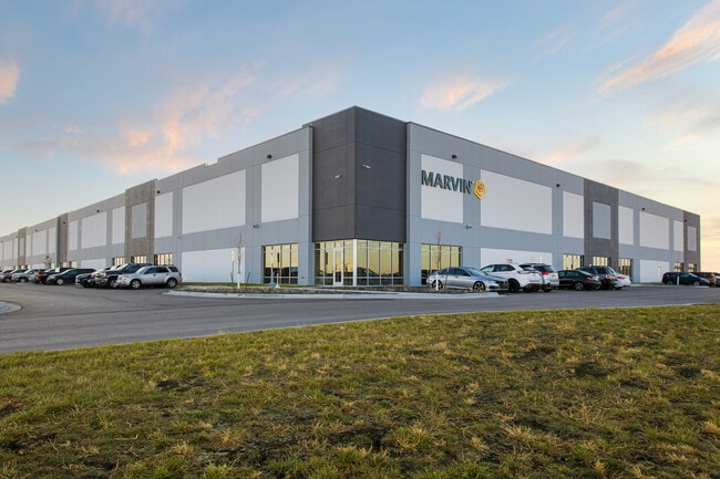
Property Record
3750 44Th Ave N, Fargo, ND 58102

NEARBY LISTINGS FOR SALE OR LEASE
Property Detail
3750 44Th Ave N
Fargo, ND-MN
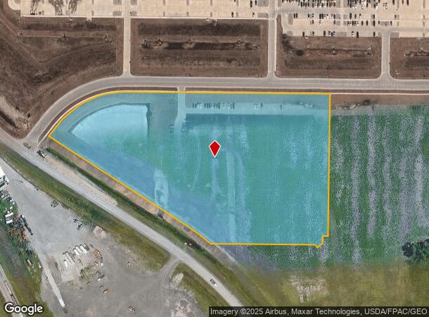
LOT: 1 BLOCK: 1 ADDITION: DAKOTA COMMERCE CENTER ADDITION ADDITIONAL: DAKOTA COMMERCE CENTER ADDITION LT 1 BLK 1 **8-6-21
01-8787-00100-000
Cass
Realpropertynec
North Dakota
2024
1
2024
Fargo
000300
Other Market Areas
DEMOGRAPHICS near 3750 44Th Ave N
1 Mile
3 Mile
5 Mile
2024 Total Population
173
3,983
50,048
2029 Population
185
4,245
53,228
Pop Growth 2024-2029
+ 6.94%
+ 6.58%
+ 6.35%
Average Age
37
39
36
2024 Total Households
61
1,745
20,682
HH Growth 2024-2029
+ 8.20%
+ 7.11%
+ 7.72%
Median Household Inc
$131,250
$76,282
$53,085
Avg Household Size
2.80
2.30
2.10
2024 Avg HH Vehicles
3.00
2.00
2.00
Median Home Value
$345,238
$302,062
$225,976
Median Year Built
2006
1990
1976
Nearby Places
Map Layers
Map Styles
 Street
 Aerial
- Restaurants
- Banks
- Shops
- Fitness
- Groceries
PUBLIC TRANSPORTATION
COMMUTER RAIL
Fargo Amtrak Station (Empire Builder - Amtrak)
DRIVE
WALK
Distance
Fargo Amtrak Station (Empire Builder - Amtrak)
13 min
7.2 mi
AIRPORT
Hector International
DRIVE
WALK
Distance
Hector International
9 min
4.3 mi
Freight Ports
Port Milwaukee
DRIVE
WALK
Distance
Port Milwaukee
637 min
580.0 mi
SALE & LEASE HISTORY
LISTING DATE
SALE/LEASE

Nov 05, 2021
For Lease
Nearby Properties
Address
Land Use
TOTAL SIZE
Lot Size
Zoning
Address
Land Use
TOTAL SIZE
Lot Size
Zoning
Address
Land Use
TOTAL SIZE
Lot Size
Zoning
122,006 SF
24.45 AC
GI
Address
Land Use
TOTAL SIZE
Lot Size
Zoning
175,969 SF
35.10 AC
GI
Address
Land Use
TOTAL SIZE
Lot Size
Zoning
12.07 AC
Address
Land Use
TOTAL SIZE
Lot Size
Zoning
Address
Land Use
TOTAL SIZE
Lot Size
Zoning
37.39 AC
Address
Land Use
TOTAL SIZE
Lot Size
Zoning
152,508 SF
13.85 AC
GI
Address
Land Use
TOTAL SIZE
Lot Size
Zoning
242,032 SF
14.23 AC
GI
Address
Land Use
TOTAL SIZE
Lot Size
Zoning
Address
Land Use
TOTAL SIZE
Lot Size
Zoning
12.97 AC
GI
Address
Land Use
TOTAL SIZE
Lot Size
Zoning
Address
Land Use
TOTAL SIZE
Lot Size
Zoning
60,125 SF
25.37 AC
LI
Address
Land Use
TOTAL SIZE
Lot Size
Zoning
10.68 AC
Address
Land Use
TOTAL SIZE
Lot Size
Zoning
122,750 SF
14.27 AC
GI
Address
Land Use
TOTAL SIZE
Lot Size
Zoning
Address
Land Use
TOTAL SIZE
Lot Size
Zoning
11.79 AC
Address
Land Use
TOTAL SIZE
Lot Size
Zoning
Address
Land Use
TOTAL SIZE
Lot Size
Zoning
90,920 SF
13.88 AC
GI
Address
Land Use
TOTAL SIZE
Lot Size
Zoning
247,888 SF
15.13 AC
GI
Address
Land Use
TOTAL SIZE
Lot Size
Zoning
3.59 AC
GI
Address
Land Use
TOTAL SIZE
Lot Size
Zoning
286,296 SF
18.30 AC
LI
Address
Land Use
TOTAL SIZE
Lot Size
Zoning
219,000 SF
11.79 AC
GI
Address
Land Use
TOTAL SIZE
Lot Size
Zoning
37,136 SF
25.16 AC
GI
Address
Land Use
TOTAL SIZE
Lot Size
Zoning
96,103 SF
6.55 AC
GI
Address
Land Use
TOTAL SIZE
Lot Size
Zoning
10.10 AC
GI
Address
Land Use
TOTAL SIZE
Lot Size
Zoning
Address
Land Use
TOTAL SIZE
Lot Size
Zoning
79,536 SF
10.99 AC
GI
Address
Land Use
TOTAL SIZE
Lot Size
Zoning
74,228 SF
13.68 AC
GI
Address
Land Use
TOTAL SIZE
Lot Size
Zoning
94,804 SF
4.50 AC
GI
The World's #1 Commercial Real Estate Marketplace
Connect with us
© 2026 CoStar Group
The information above has been obtained from sources believed reliable. While we do not doubt its accuracy we have not verified it and make no guarantee, warranty or representation about it. It is your responsibility to independently confirm its accuracy and completeness. Any projections, opinions, assumptions, or estimates used are for example only and do not represent the current or future performance of the property. The value of this transaction to you depends on tax and other factors which should be evaluated by your tax, financial, and legal advisors. You and your advisors should conduct a careful, independent investigation of the property to determine to your satisfaction the suitability of the property for your needs.