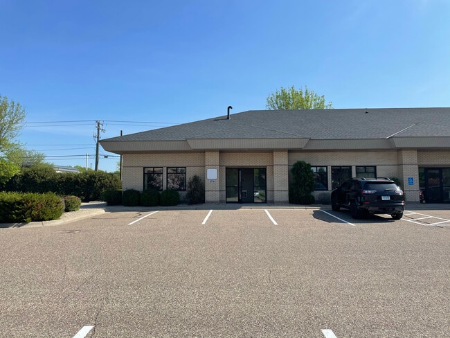
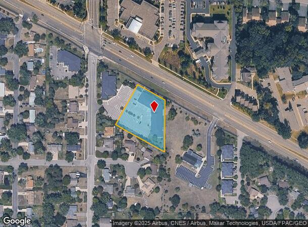
Property Record
3750 Coon Rapids Blvd Nw, Minneapolis, MN 55433
Current Lease Availabilities
Office LEASE
$14.00 - $16.00 SF/YR
2,625 - 2,785 SF
NEARBY LISTINGS FOR SALE OR LEASE
Property Detail
3750 Coon Rapids Blvd Nw
Minneapolis/St Paul
Noons Riverside 2Nd Add
Minneapolis-St. Paul-Bloomington, MN-WI
LOT 1 BLK 2 NOONS RIVERSIDE 2ND ADD, LYG SELY OF FOL DESC LINE & ITS EXTNS: COM AT NW COR OF SD LOT 1; TH ON AN ASSD BRG OF S
17-31-24-21-0073
Anoka
Commercialnec
Minnesota
2025
1
2025
Suburban St Paul
050605
DEMOGRAPHICS near 3750 Coon Rapids Blvd Nw
1 Mile
3 Mile
5 Mile
2024 Total Population
11,494
78,933
174,040
2029 Population
11,738
80,183
177,043
Pop Growth 2024-2029
+ 2.12%
+ 1.58%
+ 1.73%
Average Age
41
40
40
2024 Total Households
4,564
30,519
64,263
HH Growth 2024-2029
+ 2.28%
+ 1.77%
+ 1.81%
Median Household Inc
$76,113
$82,952
$90,706
Avg Household Size
2.50
2.50
2.60
2024 Avg HH Vehicles
2.00
2.00
2.00
Median Home Value
$275,462
$279,719
$290,186
Median Year Built
1981
1983
1986
Nearby Places
- Restaurants
- Banks
- Shops
- Fitness
- Groceries
PUBLIC TRANSPORTATION
COMMUTER RAIL
Coon Rapids-Riverdale Station (Northstar Corridor - Northstar Commuter Rail)
DRIVE
WALK
Distance
Coon Rapids-Riverdale Station (Northstar Corridor - Northstar Commuter Rail)
5 min
1.8 mi
Anoka Station (Northstar Corridor - Northstar Commuter Rail)
DRIVE
WALK
Distance
Anoka Station (Northstar Corridor - Northstar Commuter Rail)
6 min
2.8 mi
AIRPORT
Minneapolis-St Paul International/Wold-Chamberlain
DRIVE
WALK
Distance
Minneapolis-St Paul International/Wold-Chamberlain
46 min
28.6 mi
Freight Ports
Port Milwaukee
DRIVE
WALK
Distance
Port Milwaukee
392 min
354.5 mi
Nearby Properties
Address
Land Use
TOTAL SIZE
Lot Size
Zoning
Address
Land Use
TOTAL SIZE
Lot Size
Zoning
517,619 SF
3.85 AC
Address
Land Use
TOTAL SIZE
Lot Size
Zoning
468,099 SF
5.73 AC
MSMU
Address
Land Use
TOTAL SIZE
Lot Size
Zoning
412,914 SF
40 AC
Address
Land Use
TOTAL SIZE
Lot Size
Zoning
3.80 AC
Address
Land Use
TOTAL SIZE
Lot Size
Zoning
319,826 SF
37.97 AC
Address
Land Use
TOTAL SIZE
Lot Size
Zoning
2,400 SF
72.45 AC
Address
Land Use
TOTAL SIZE
Lot Size
Zoning
5,110 SF
38.62 AC
Address
Land Use
TOTAL SIZE
Lot Size
Zoning
Address
Land Use
TOTAL SIZE
Lot Size
Zoning
122,816 SF
27.84 AC
Address
Land Use
TOTAL SIZE
Lot Size
Zoning
4.99 AC
Address
Land Use
TOTAL SIZE
Lot Size
Zoning
Address
Land Use
TOTAL SIZE
Lot Size
Zoning
129,060 SF
10.21 AC
Address
Land Use
TOTAL SIZE
Lot Size
Zoning
13.63 AC
Address
Land Use
TOTAL SIZE
Lot Size
Zoning
167 SF
4.73 AC
Address
Land Use
TOTAL SIZE
Lot Size
Zoning
Address
Land Use
TOTAL SIZE
Lot Size
Zoning
15.23 AC
Address
Land Use
TOTAL SIZE
Lot Size
Zoning
Address
Land Use
TOTAL SIZE
Lot Size
Zoning
13.44 AC
Address
Land Use
TOTAL SIZE
Lot Size
Zoning
159,335 SF
13.64 AC
Address
Land Use
TOTAL SIZE
Lot Size
Zoning
168,887 SF
7.01 AC
Address
Land Use
TOTAL SIZE
Lot Size
Zoning
148 SF
39.49 AC
Address
Land Use
TOTAL SIZE
Lot Size
Zoning
14.27 AC
Address
Land Use
TOTAL SIZE
Lot Size
Zoning
114,281 SF
3.19 AC
PRD-4
Address
Land Use
TOTAL SIZE
Lot Size
Zoning
11.55 AC
Address
Land Use
TOTAL SIZE
Lot Size
Zoning
Address
Land Use
TOTAL SIZE
Lot Size
Zoning
118,208 SF
Address
Land Use
TOTAL SIZE
Lot Size
Zoning
Address
Land Use
TOTAL SIZE
Lot Size
Zoning
Address
Land Use
TOTAL SIZE
Lot Size
Zoning
151,862 SF
12.97 AC
Address
Land Use
TOTAL SIZE
Lot Size
Zoning
155,849 SF
0.83 AC
The World's #1 Commercial Real Estate Marketplace
Connect with us
© 2025 CoStar Group
The information above has been obtained from sources believed reliable. While we do not doubt its accuracy we have not verified it and make no guarantee, warranty or representation about it. It is your responsibility to independently confirm its accuracy and completeness. Any projections, opinions, assumptions, or estimates used are for example only and do not represent the current or future performance of the property. The value of this transaction to you depends on tax and other factors which should be evaluated by your tax, financial, and legal advisors. You and your advisors should conduct a careful, independent investigation of the property to determine to your satisfaction the suitability of the property for your needs.