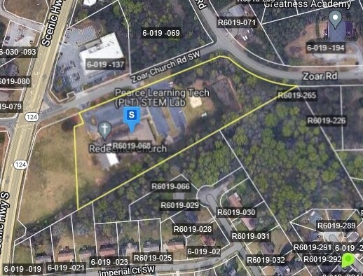
Property Record
3750 Zoar Church Rd, Snellville, GA 30039


NEARBY LISTINGS FOR SALE OR LEASE
-
-
View all Snellville listings for sale on LoopNet.com
Property Detail
3750 Zoar Church Rd
Atlanta-Sandy Springs-Roswell, GA
Ga Hwy 124
6-019-068
TRACT 1 ZOAR CHURCH RD SURVEY 161-158
Religious
Gwinnett
X
Georgia
13247C0020D
3
2025
7.29 AC
2025
Lawrenceville/Lilburn
050722
Atlanta
23,930 SF
DEMOGRAPHICS near 3750 Zoar Church Rd
1 Mile
3 Mile
5 Mile
2024 Total Population
8,108
58,447
136,544
2029 Population
8,396
60,433
140,738
Pop Growth 2024-2029
+ 3.55%
+ 3.40%
+ 3.07%
Average Age
37
38
39
2024 Total Households
2,544
19,000
44,913
HH Growth 2024-2029
+ 3.66%
+ 3.48%
+ 3.11%
Median Household Inc
$84,204
$76,988
$82,824
Avg Household Size
3.10
3.00
3.00
2024 Avg HH Vehicles
2.00
2.00
2.00
Median Home Value
$302,126
$262,948
$267,317
Median Year Built
1986
1989
1989
Nearby Places
Map Layers
Map Styles
 Street
 Aerial
- Restaurants
- Banks
- Shops
- Fitness
- Groceries
PUBLIC TRANSPORTATION
AIRPORT
Hartsfield - Jackson Atlanta International
DRIVE
WALK
Distance
Hartsfield - Jackson Atlanta International
48 min
31.8 mi
Nearby Properties
Address
Land Use
TOTAL SIZE
Lot Size
Zoning
Address
Land Use
TOTAL SIZE
Lot Size
Zoning
301,646 SF
23.90 AC
RM13
Address
Land Use
TOTAL SIZE
Lot Size
Zoning
462,669 SF
102.65 AC
R100
Address
Land Use
TOTAL SIZE
Lot Size
Zoning
278,756 SF
27.72 AC
RM
Address
Land Use
TOTAL SIZE
Lot Size
Zoning
3,500 SF
391.26 AC
R100
Address
Land Use
TOTAL SIZE
Lot Size
Zoning
129,843 SF
30.97 AC
R100
Address
Land Use
TOTAL SIZE
Lot Size
Zoning
175,045 SF
13.01 AC
RM
Address
Land Use
TOTAL SIZE
Lot Size
Zoning
23,692 SF
112.46 AC
RA200
Address
Land Use
TOTAL SIZE
Lot Size
Zoning
113,100 SF
11.39 AC
C2
Address
Land Use
TOTAL SIZE
Lot Size
Zoning
196,333 SF
23.27 AC
RS180
Address
Land Use
TOTAL SIZE
Lot Size
Zoning
139,448 SF
15.97 AC
RM
Address
Land Use
TOTAL SIZE
Lot Size
Zoning
217,730 SF
29.68 AC
C2
Address
Land Use
TOTAL SIZE
Lot Size
Zoning
54.06 AC
R100
Address
Land Use
TOTAL SIZE
Lot Size
Zoning
99,280 SF
4.51 AC
C2
Address
Land Use
TOTAL SIZE
Lot Size
Zoning
100,427 SF
22.60 AC
RA200
Address
Land Use
TOTAL SIZE
Lot Size
Zoning
103,821 SF
10.80 AC
M1
Address
Land Use
TOTAL SIZE
Lot Size
Zoning
48,985 SF
17.87 AC
C2
Address
Land Use
TOTAL SIZE
Lot Size
Zoning
57,322 SF
9.18 AC
C2
Address
Land Use
TOTAL SIZE
Lot Size
Zoning
151,922 SF
18.19 AC
R100
Address
Land Use
TOTAL SIZE
Lot Size
Zoning
91,096 SF
28.67 AC
OI
Address
Land Use
TOTAL SIZE
Lot Size
Zoning
100,000 SF
10.39 AC
C2
Address
Land Use
TOTAL SIZE
Lot Size
Zoning
99,893 SF
7.48 AC
OI
Address
Land Use
TOTAL SIZE
Lot Size
Zoning
52,262 SF
6.02 AC
C3
Address
Land Use
TOTAL SIZE
Lot Size
Zoning
103,700 SF
10.20 AC
C2
Address
Land Use
TOTAL SIZE
Lot Size
Zoning
90,000 SF
9.32 AC
M1
Address
Land Use
TOTAL SIZE
Lot Size
Zoning
88,110 SF
8.01 AC
C2
Address
Land Use
TOTAL SIZE
Lot Size
Zoning
90,151 SF
2.38 AC
C2
Address
Land Use
TOTAL SIZE
Lot Size
Zoning
57,206 SF
7 AC
C2
Address
Land Use
TOTAL SIZE
Lot Size
Zoning
68,800 SF
9.01 AC
C2
Address
Land Use
TOTAL SIZE
Lot Size
Zoning
1,296 SF
65.93 AC
R100
Address
Land Use
TOTAL SIZE
Lot Size
Zoning
72,148 SF
23.23 AC
R100
The World's #1 Commercial Real Estate Marketplace
Connect with us
© 2025 CoStar Group
The information above has been obtained from sources believed reliable. While we do not doubt its accuracy we have not verified it and make no guarantee, warranty or representation about it. It is your responsibility to independently confirm its accuracy and completeness. Any projections, opinions, assumptions, or estimates used are for example only and do not represent the current or future performance of the property. The value of this transaction to you depends on tax and other factors which should be evaluated by your tax, financial, and legal advisors. You and your advisors should conduct a careful, independent investigation of the property to determine to your satisfaction the suitability of the property for your needs.