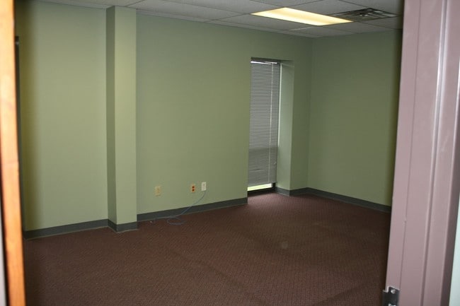
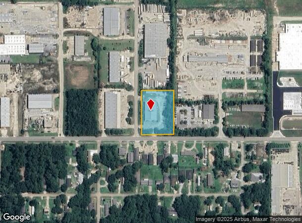
Property Record
37505 Brownsvillage Rd, Slidell, LA 70460

NEARBY LISTINGS FOR SALE OR LEASE
Property Detail
37505 Brownsvillage Rd
New Orleans-Metairie, LA
Commercial Brown's Village Rd
111217
1.50 ACS SEC 27 8 14 INST NO 1017754 INST NO 2070806 INST NO 2181669
Commercialnec
St Tammany
ARE
Louisiana
2025
1.50 AC
2024
Slidell
040713
New Orleans/Metairie/Kenner
9,940 SF
DEMOGRAPHICS near 37505 Brownsvillage Rd
1 Mile
3 Mile
5 Mile
2024 Total Population
4,159
38,934
87,189
2029 Population
4,478
41,865
93,821
Pop Growth 2024-2029
+ 7.67%
+ 7.53%
+ 7.61%
Average Age
39
40
40
2024 Total Households
1,568
14,799
33,211
HH Growth 2024-2029
+ 7.65%
+ 7.53%
+ 7.65%
Median Household Inc
$53,880
$58,258
$58,928
Avg Household Size
2.60
2.60
2.60
2024 Avg HH Vehicles
2.00
2.00
2.00
Median Home Value
$149,340
$174,552
$186,217
Median Year Built
1983
1983
1988
Nearby Places
Map Layers
Map Styles
 Street
 Aerial
- Restaurants
- Banks
- Shops
- Fitness
- Groceries
PUBLIC TRANSPORTATION
COMMUTER RAIL
Slidell Amtrak Station (Crescent - Amtrak)
DRIVE
WALK
Distance
Slidell Amtrak Station (Crescent - Amtrak)
5 min
2.9 mi
Freight Ports
Port of New Orleans
DRIVE
WALK
Distance
Port of New Orleans
51 min
39.1 mi
SALE & LEASE HISTORY
LISTING DATE
SALE/LEASE

Sep 18, 2020
For Sale
Feb 06, 2019
For Sale
Aug 08, 2017
For Lease
Nearby Properties
Address
Land Use
TOTAL SIZE
Lot Size
Zoning
Address
Land Use
TOTAL SIZE
Lot Size
Zoning
858,000 SF
59.39 AC
Address
Land Use
TOTAL SIZE
Lot Size
Zoning
660,450 SF
68.42 AC
Address
Land Use
TOTAL SIZE
Lot Size
Zoning
120,000 SF
6.75 AC
Address
Land Use
TOTAL SIZE
Lot Size
Zoning
104,000 SF
2.89 AC
Address
Land Use
TOTAL SIZE
Lot Size
Zoning
205,496 SF
27.47 AC
Address
Land Use
TOTAL SIZE
Lot Size
Zoning
192,685 SF
Address
Land Use
TOTAL SIZE
Lot Size
Zoning
197,221 SF
1.60 AC
Address
Land Use
TOTAL SIZE
Lot Size
Zoning
157,561 SF
10.06 AC
Address
Land Use
TOTAL SIZE
Lot Size
Zoning
137,402 SF
76.02 AC
Address
Land Use
TOTAL SIZE
Lot Size
Zoning
132,961 SF
12.06 AC
Address
Land Use
TOTAL SIZE
Lot Size
Zoning
123,155 SF
15 AC
Address
Land Use
TOTAL SIZE
Lot Size
Zoning
127,681 SF
3 AC
Address
Land Use
TOTAL SIZE
Lot Size
Zoning
63,135 SF
12.49 AC
Address
Land Use
TOTAL SIZE
Lot Size
Zoning
105,633 SF
11 AC
Address
Land Use
TOTAL SIZE
Lot Size
Zoning
104,821 SF
10.09 AC
Address
Land Use
TOTAL SIZE
Lot Size
Zoning
105,300 SF
8.75 AC
Address
Land Use
TOTAL SIZE
Lot Size
Zoning
118,344 SF
Address
Land Use
TOTAL SIZE
Lot Size
Zoning
144,674 SF
13.10 AC
Address
Land Use
TOTAL SIZE
Lot Size
Zoning
142,482 SF
1.23 AC
Address
Land Use
TOTAL SIZE
Lot Size
Zoning
84,000 SF
10.84 AC
Address
Land Use
TOTAL SIZE
Lot Size
Zoning
85,000 SF
12.23 AC
Address
Land Use
TOTAL SIZE
Lot Size
Zoning
115,568 SF
0.21 AC
Address
Land Use
TOTAL SIZE
Lot Size
Zoning
184,551 SF
20 AC
Address
Land Use
TOTAL SIZE
Lot Size
Zoning
91,149 SF
4.26 AC
Address
Land Use
TOTAL SIZE
Lot Size
Zoning
115,666 SF
9.14 AC
Address
Land Use
TOTAL SIZE
Lot Size
Zoning
104,702 SF
11.69 AC
Address
Land Use
TOTAL SIZE
Lot Size
Zoning
78,250 SF
4.78 AC
Address
Land Use
TOTAL SIZE
Lot Size
Zoning
114,806 SF
10.22 AC
Address
Land Use
TOTAL SIZE
Lot Size
Zoning
66,634 SF
14 AC
Address
Land Use
TOTAL SIZE
Lot Size
Zoning
46,476 SF
5.81 AC
The World's #1 Commercial Real Estate Marketplace
Connect with us
© 2025 CoStar Group
The information above has been obtained from sources believed reliable. While we do not doubt its accuracy we have not verified it and make no guarantee, warranty or representation about it. It is your responsibility to independently confirm its accuracy and completeness. Any projections, opinions, assumptions, or estimates used are for example only and do not represent the current or future performance of the property. The value of this transaction to you depends on tax and other factors which should be evaluated by your tax, financial, and legal advisors. You and your advisors should conduct a careful, independent investigation of the property to determine to your satisfaction the suitability of the property for your needs.