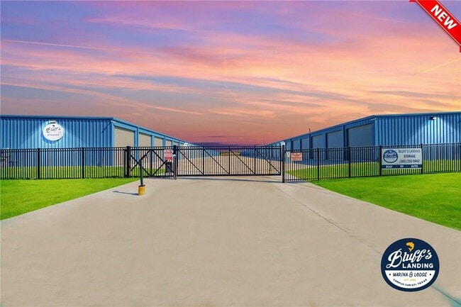
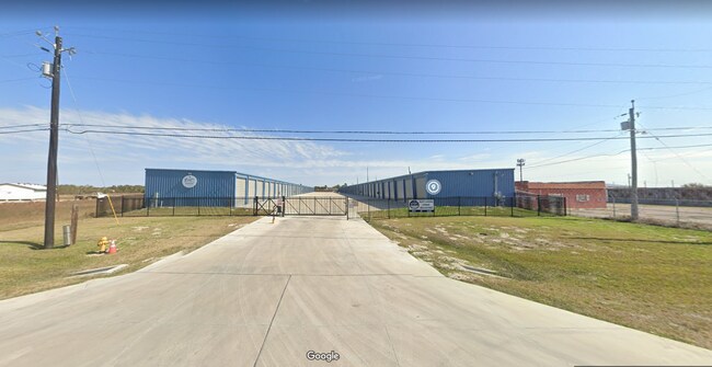
Property Record
3753 Waldron Rd, Corpus Christi, TX 78418

Property Detail
3753 Waldron Rd
Corpus Christi, TX
YORKWALD ACRES LOT 11
586345
Nueces
Commercialnec
Texas
B and X Area of moderate flood hazard, usually the area between the limits of the 100-year and 500-year floods.
11
2024
2.32 AC
2025
Flour Bluff/Padre Island
003101
Corpus Christi
NEARBY LISTINGS FOR SALE OR LEASE
-
-
View all Corpus Christi listings for sale on LoopNet.com
DEMOGRAPHICS near 3753 Waldron Rd
1 mile
3 mile
5 mile
2024 Total Population
4,144
15,185
57,546
2029 Population
4,135
15,180
57,815
Pop Growth 2024-2029
(0.22%)
(0.03%)
+ 0.47%
Average Age
42
40
38
2024 Total Households
1,535
5,519
21,624
HH Growth 2024-2029
(0.33%)
(0.22%)
+ 0.21%
Median Household Inc
$86,441
$91,240
$93,805
Avg Household Size
2.60
2.70
2.60
2024 Avg HH Vehicles
2.00
2.00
2.00
Median Home Value
$255,038
$251,064
$276,634
Median Year Built
1983
1987
2000
Nearby Places
Map Layers
Map Styles
 Street
 Aerial
Transit
 Traffic
 Biking
Places
Listings with unknown addresses are not visible on the map
- Restaurants
- Banks
- Shops
- Fitness
- Groceries
PUBLIC TRANSPORTATION
AIRPORT
Corpus Christi International
Drive
Walk
Distance
Corpus Christi International
32 min
21.3 mi
Freight Ports
Port of Corpus Christi
Drive
Walk
Distance
Port of Corpus Christi
27 min
17.1 mi
SALE & LEASE HISTORY
LISTING DATE
SALE/LEASE

Feb 03, 2023
For Sale
Nearby Properties
Address
Land Use
TOTAL SIZE
Lot Size
Zoning
Address
Land Use
TOTAL SIZE
Lot Size
Zoning
754,977 SF
93 AC
VII
Address
Land Use
TOTAL SIZE
Lot Size
Zoning
257,979 SF
40.14 AC
Address
Land Use
TOTAL SIZE
Lot Size
Zoning
2,884 SF
621 AC
R-1B
Address
Land Use
TOTAL SIZE
Lot Size
Zoning
60,829 SF
44.79 AC
Address
Land Use
TOTAL SIZE
Lot Size
Zoning
32,204 SF
5.52 AC
Address
Land Use
TOTAL SIZE
Lot Size
Zoning
Address
Land Use
TOTAL SIZE
Lot Size
Zoning
6,186 SF
11.85 AC
T-1B
Address
Land Use
TOTAL SIZE
Lot Size
Zoning
3,500 SF
11.09 AC
B-4
Address
Land Use
TOTAL SIZE
Lot Size
Zoning
1,841 SF
21.13 AC
A1
Address
Land Use
TOTAL SIZE
Lot Size
Zoning
5.76 AC
I3
Address
Land Use
TOTAL SIZE
Lot Size
Zoning
4,000 SF
4 AC
Address
Land Use
TOTAL SIZE
Lot Size
Zoning
28.09 AC
B-4&R1-B
Address
Land Use
TOTAL SIZE
Lot Size
Zoning
34,801 SF
8.34 AC
R1B
Address
Land Use
TOTAL SIZE
Lot Size
Zoning
2,016 SF
7 AC
Address
Land Use
TOTAL SIZE
Lot Size
Zoning
12,228 SF
6.81 AC
RE
Address
Land Use
TOTAL SIZE
Lot Size
Zoning
320 SF
1,990.11 AC
I3
Address
Land Use
TOTAL SIZE
Lot Size
Zoning
Address
Land Use
TOTAL SIZE
Lot Size
Zoning
7,448 SF
9.62 AC
T-1A&B
Address
Land Use
TOTAL SIZE
Lot Size
Zoning
28.57 AC
FR
Address
Land Use
TOTAL SIZE
Lot Size
Zoning
6.04 AC
R1B
Address
Land Use
TOTAL SIZE
Lot Size
Zoning
9,376 SF
1.64 AC
R-1B
Address
Land Use
TOTAL SIZE
Lot Size
Zoning
39,594 SF
4.24 AC
B3
Address
Land Use
TOTAL SIZE
Lot Size
Zoning
6,826 SF
1.53 AC
Address
Land Use
TOTAL SIZE
Lot Size
Zoning
65.91 AC
R-1B
Address
Land Use
TOTAL SIZE
Lot Size
Zoning
28,444 SF
6.45 AC
I2
Address
Land Use
TOTAL SIZE
Lot Size
Zoning
38,624 SF
3.13 AC
R1B
Address
Land Use
TOTAL SIZE
Lot Size
Zoning
19.50 AC
FR
Address
Land Use
TOTAL SIZE
Lot Size
Zoning
10,745 SF
2.05 AC
B-3
Address
Land Use
TOTAL SIZE
Lot Size
Zoning
16,168 SF
1.48 AC
R1B
The World's #1 Commercial Real Estate Marketplace
Connect with us
© 2026 CoStar Group
The information above has been obtained from sources believed reliable. While we do not doubt its accuracy we have not verified it and make no guarantee, warranty or representation about it. It is your responsibility to independently confirm its accuracy and completeness. Any projections, opinions, assumptions, or estimates used are for example only and do not represent the current or future performance of the property. The value of this transaction to you depends on tax and other factors which should be evaluated by your tax, financial, and legal advisors. You and your advisors should conduct a careful, independent investigation of the property to determine to your satisfaction the suitability of the property for your needs.