Property Record
3755 Green Brier Blvd, Ann Arbor, MI 48105
NEARBY LISTINGS FOR SALE OR LEASE
-
-
View all Ann Arbor listings for sale on LoopNet.com
Property Detail
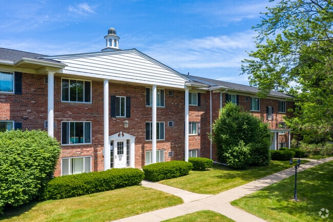
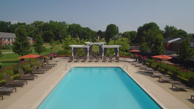
3755 Green Brier Blvd
Ann Arbor, MI
Green Brier Sub
09-23-100-006
PRT NE 1/4 SEC 23 T2S R6E COM NW COR LOT 74 GREEN BRIER SUB NO 2 TH 84.30 FT IN ARC CIR CURVE R-320 FT TH 5.87 FT ON ARC CIR
Commercialnec
Washtenaw
X
Michigan
26161C0266E
74
2025
4.64 AC
2025
Ann Arbor Scio
402500
Detroit
107,760 SF
DEMOGRAPHICS near 3755 Green Brier Blvd
1 Mile
3 Mile
5 Mile
2024 Total Population
8,794
62,212
152,416
2029 Population
8,632
61,610
150,781
Pop Growth 2024-2029
(1.84%)
(0.97%)
(1.07%)
Average Age
35
33
36
2024 Total Households
3,029
22,628
62,754
HH Growth 2024-2029
(1.49%)
(0.73%)
(1.06%)
Median Household Inc
$86,952
$69,526
$69,973
Avg Household Size
2.20
2.20
2.10
2024 Avg HH Vehicles
1.00
1.00
2.00
Median Home Value
$450,961
$482,732
$393,614
Median Year Built
1973
1976
1973
Nearby Places
Map Layers
Map Styles
 Street
 Aerial
- Restaurants
- Banks
- Shops
- Fitness
- Groceries
PUBLIC TRANSPORTATION
COMMUTER RAIL
Ann Arbor Amtrak Station (Wolverine - Amtrak)
DRIVE
WALK
Distance
Ann Arbor Amtrak Station (Wolverine - Amtrak)
9 min
3.8 mi
AIRPORT
Detroit Metro Wayne County
DRIVE
WALK
Distance
Detroit Metro Wayne County
35 min
27.1 mi
Freight Ports
Port of Toledo
DRIVE
WALK
Distance
Port of Toledo
77 min
60.1 mi
Nearby Properties
Address
Land Use
TOTAL SIZE
Lot Size
Zoning
Address
Land Use
TOTAL SIZE
Lot Size
Zoning
235,070 SF
0.80 AC
D1
Address
Land Use
TOTAL SIZE
Lot Size
Zoning
358,683 SF
5.42 AC
PUD
Address
Land Use
TOTAL SIZE
Lot Size
Zoning
407,374 SF
35.17 AC
C3
Address
Land Use
TOTAL SIZE
Lot Size
Zoning
211,670 SF
0.54 AC
D1
Address
Land Use
TOTAL SIZE
Lot Size
Zoning
222,126 SF
0.52 AC
D1
Address
Land Use
TOTAL SIZE
Lot Size
Zoning
401,491 SF
3.12 AC
C1A/R
Address
Land Use
TOTAL SIZE
Lot Size
Zoning
2,668 SF
31.60 AC
PUD
Address
Land Use
TOTAL SIZE
Lot Size
Zoning
524,946 SF
10.43 AC
PUD
Address
Land Use
TOTAL SIZE
Lot Size
Zoning
301,086 SF
21.41 AC
R4A
Address
Land Use
TOTAL SIZE
Lot Size
Zoning
173,885 SF
0.45 AC
D1
Address
Land Use
TOTAL SIZE
Lot Size
Zoning
323,630 SF
21.55 AC
UNKNOWN
Address
Land Use
TOTAL SIZE
Lot Size
Zoning
249,612 SF
1.87 AC
C1A/R
Address
Land Use
TOTAL SIZE
Lot Size
Zoning
99,982 SF
0.35 AC
D1
Address
Land Use
TOTAL SIZE
Lot Size
Zoning
324,832 SF
18.81 AC
R4A
Address
Land Use
TOTAL SIZE
Lot Size
Zoning
273,440 SF
73.06 AC
RRA
Address
Land Use
TOTAL SIZE
Lot Size
Zoning
208,890 SF
A-1
Address
Land Use
TOTAL SIZE
Lot Size
Zoning
125,073 SF
0.26 AC
D1
Address
Land Use
TOTAL SIZE
Lot Size
Zoning
219,322 SF
19.82 AC
R4D
Address
Land Use
TOTAL SIZE
Lot Size
Zoning
114,208 SF
8.63 AC
PUD
Address
Land Use
TOTAL SIZE
Lot Size
Zoning
202,219 SF
22.84 AC
PUD
Address
Land Use
TOTAL SIZE
Lot Size
Zoning
1.19 AC
R4C
Address
Land Use
TOTAL SIZE
Lot Size
Zoning
5,416 SF
30.14 AC
R-9
Address
Land Use
TOTAL SIZE
Lot Size
Zoning
919,507 SF
17.53 AC
OP
Address
Land Use
TOTAL SIZE
Lot Size
Zoning
919,507 SF
20.95 AC
OP
Address
Land Use
TOTAL SIZE
Lot Size
Zoning
340,425 SF
31.50 AC
R4B
Address
Land Use
TOTAL SIZE
Lot Size
Zoning
919,507 SF
15.40 AC
RC
Address
Land Use
TOTAL SIZE
Lot Size
Zoning
119,631 SF
7.85 AC
PUD
Address
Land Use
TOTAL SIZE
Lot Size
Zoning
143,619 SF
0.20 AC
PUD
Address
Land Use
TOTAL SIZE
Lot Size
Zoning
919,507 SF
16.06 AC
OP
Address
Land Use
TOTAL SIZE
Lot Size
Zoning
163,812 SF
6.96 AC
R4D
The World's #1 Commercial Real Estate Marketplace
Connect with us
© 2026 CoStar Group
The information above has been obtained from sources believed reliable. While we do not doubt its accuracy we have not verified it and make no guarantee, warranty or representation about it. It is your responsibility to independently confirm its accuracy and completeness. Any projections, opinions, assumptions, or estimates used are for example only and do not represent the current or future performance of the property. The value of this transaction to you depends on tax and other factors which should be evaluated by your tax, financial, and legal advisors. You and your advisors should conduct a careful, independent investigation of the property to determine to your satisfaction the suitability of the property for your needs.