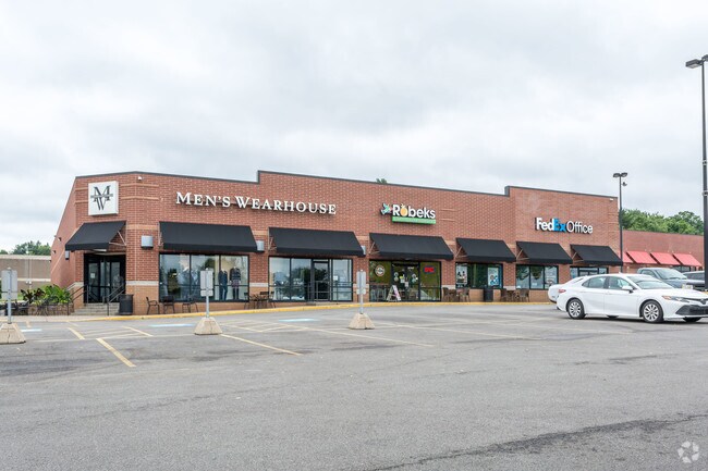
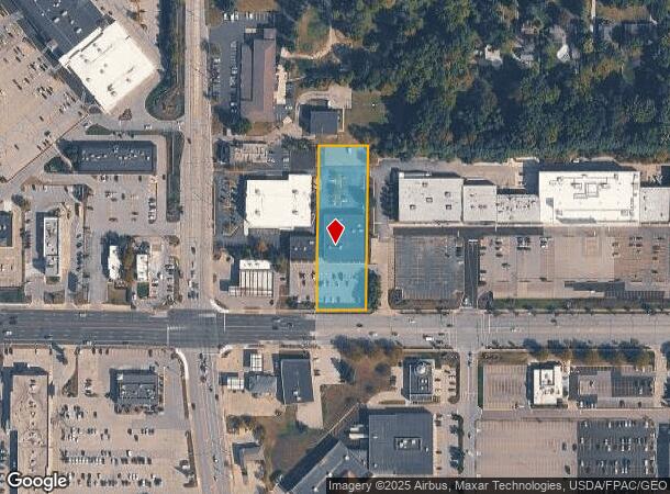
Property Record
3757 A-B Medina Rd, Akron, OH 44333
NEARBY LISTINGS FOR SALE OR LEASE
Property Detail
3757 A-B Medina Rd
Akron, OH
LOT 95 SUB 10 LESS PT FOR RD
05-00450
Summit
Regionalshoppingcenterormallwithanchorstore
Ohio
2023
95
2025
1.32 AC
532302
Fairlawn/Montrose
14,375 SF
Cleveland
DEMOGRAPHICS near 3757 A-B Medina Rd
1 Mile
3 Mile
5 Mile
2024 Total Population
3,338
33,563
66,675
2029 Population
3,286
33,105
65,856
Pop Growth 2024-2029
(1.56%)
(1.36%)
(1.23%)
Average Age
51
44
43
2024 Total Households
1,623
13,841
28,740
HH Growth 2024-2029
(1.73%)
(1.42%)
(1.28%)
Median Household Inc
$85,655
$105,644
$85,000
Avg Household Size
1.80
2.30
2.30
2024 Avg HH Vehicles
2.00
2.00
2.00
Median Home Value
$299,773
$307,334
$255,117
Median Year Built
1982
1979
1970
Nearby Places
Map Layers
Map Styles
 Street
 Aerial
- Restaurants
- Banks
- Shops
- Fitness
- Groceries
PUBLIC TRANSPORTATION
COMMUTER RAIL
Botzum (National Park Scenic Railway - Cuyahoga Valley Scenic Railroad)
DRIVE
WALK
Distance
Botzum (National Park Scenic Railway - Cuyahoga Valley Scenic Railroad)
11 min
5.3 mi
Indigo Lake (National Park Scenic Railway - Cuyahoga Valley Scenic Railroad)
DRIVE
WALK
Distance
Indigo Lake (National Park Scenic Railway - Cuyahoga Valley Scenic Railroad)
15 min
7.0 mi
AIRPORT
Akron-Canton Regional
DRIVE
WALK
Distance
Akron-Canton Regional
31 min
22.6 mi
Cleveland-Hopkins International
DRIVE
WALK
Distance
Cleveland-Hopkins International
43 min
30.7 mi
Freight Ports
Port of Toledo
DRIVE
WALK
Distance
Port of Toledo
148 min
126.2 mi
Nearby Properties
Address
Land Use
TOTAL SIZE
Lot Size
Zoning
Address
Land Use
TOTAL SIZE
Lot Size
Zoning
12.92 AC
Address
Land Use
TOTAL SIZE
Lot Size
Zoning
676,403 SF
39.06 AC
Address
Land Use
TOTAL SIZE
Lot Size
Zoning
Address
Land Use
TOTAL SIZE
Lot Size
Zoning
324,548 SF
64.18 AC
Address
Land Use
TOTAL SIZE
Lot Size
Zoning
311,093 SF
32.53 AC
Address
Land Use
TOTAL SIZE
Lot Size
Zoning
72,026 SF
7.92 AC
Address
Land Use
TOTAL SIZE
Lot Size
Zoning
192,658 SF
15.34 AC
Address
Land Use
TOTAL SIZE
Lot Size
Zoning
411,220 SF
54.72 AC
Address
Land Use
TOTAL SIZE
Lot Size
Zoning
439,456 SF
26.40 AC
Address
Land Use
TOTAL SIZE
Lot Size
Zoning
164,214 SF
12.92 AC
Address
Land Use
TOTAL SIZE
Lot Size
Zoning
214,600 SF
14.12 AC
Address
Land Use
TOTAL SIZE
Lot Size
Zoning
180,624 SF
24.21 AC
Address
Land Use
TOTAL SIZE
Lot Size
Zoning
135,300 SF
6.75 AC
Address
Land Use
TOTAL SIZE
Lot Size
Zoning
226,341 SF
18.81 AC
Address
Land Use
TOTAL SIZE
Lot Size
Zoning
77,096 SF
6.21 AC
Address
Land Use
TOTAL SIZE
Lot Size
Zoning
Address
Land Use
TOTAL SIZE
Lot Size
Zoning
54,592 SF
11.32 AC
Address
Land Use
TOTAL SIZE
Lot Size
Zoning
231,968 SF
29.14 AC
Address
Land Use
TOTAL SIZE
Lot Size
Zoning
87,071 SF
18.03 AC
Address
Land Use
TOTAL SIZE
Lot Size
Zoning
148,292 SF
18.43 AC
Address
Land Use
TOTAL SIZE
Lot Size
Zoning
Address
Land Use
TOTAL SIZE
Lot Size
Zoning
73,301 SF
5.55 AC
Address
Land Use
TOTAL SIZE
Lot Size
Zoning
147,635 SF
15.14 AC
Address
Land Use
TOTAL SIZE
Lot Size
Zoning
129,308 SF
19.02 AC
Address
Land Use
TOTAL SIZE
Lot Size
Zoning
179,805 SF
12.87 AC
Address
Land Use
TOTAL SIZE
Lot Size
Zoning
132,886 SF
10.87 AC
Address
Land Use
TOTAL SIZE
Lot Size
Zoning
148,199 SF
58.56 AC
Address
Land Use
TOTAL SIZE
Lot Size
Zoning
126,710 SF
12.67 AC
Address
Land Use
TOTAL SIZE
Lot Size
Zoning
61,414 SF
4.88 AC
Address
Land Use
TOTAL SIZE
Lot Size
Zoning
159,086 SF
8.36 AC
The World's #1 Commercial Real Estate Marketplace
Connect with us
© 2025 CoStar Group
The information above has been obtained from sources believed reliable. While we do not doubt its accuracy we have not verified it and make no guarantee, warranty or representation about it. It is your responsibility to independently confirm its accuracy and completeness. Any projections, opinions, assumptions, or estimates used are for example only and do not represent the current or future performance of the property. The value of this transaction to you depends on tax and other factors which should be evaluated by your tax, financial, and legal advisors. You and your advisors should conduct a careful, independent investigation of the property to determine to your satisfaction the suitability of the property for your needs.