Property Record
3758 County Road 74, Saint Cloud, MN 56301
This Property Is For Sale
NEARBY LISTINGS FOR SALE OR LEASE
Property Detail
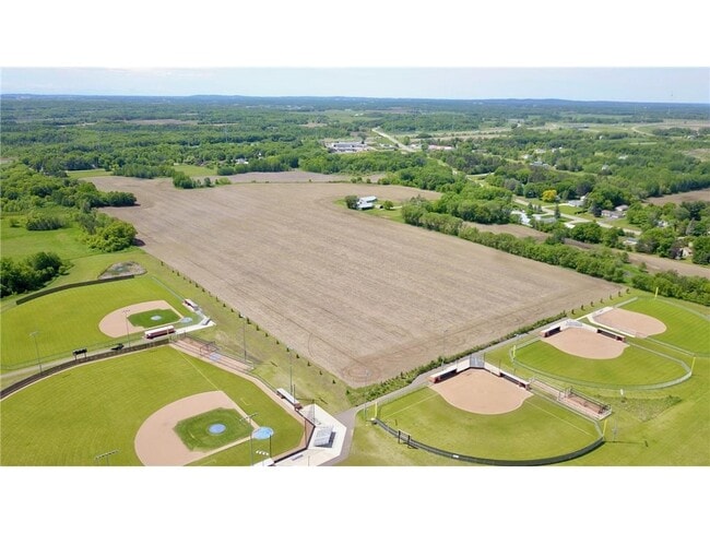
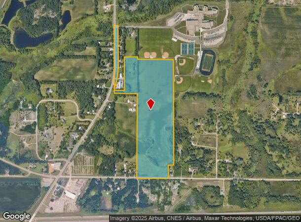
3758 County Road 74
St. Cloud, MN
33-124-28 56.50A W2SW4 & S2NW4 LESS PART BEG AT A PT ON E ROW HWY 15 1 ROD N OF S LN SW4NW4-E 8 RODS-S 715'-W 212' TO ELY
82.44152.0729
Stearns
Agriculturalland
Minnesota
2024
56.50 AC
2025
Stearns County
000401
Minneapolis/St Paul
DEMOGRAPHICS near 3758 County Road 74
1 Mile
3 Mile
5 Mile
2024 Total Population
378
18,689
64,546
2029 Population
409
19,664
67,276
Pop Growth 2024-2029
+ 8.20%
+ 5.22%
+ 4.23%
Average Age
35
38
37
2024 Total Households
158
7,442
24,877
HH Growth 2024-2029
+ 8.23%
+ 5.16%
+ 4.33%
Median Household Inc
$59,473
$60,692
$54,548
Avg Household Size
2.30
2.40
2.40
2024 Avg HH Vehicles
2.00
2.00
2.00
Median Home Value
$268,181
$266,419
$199,183
Median Year Built
2004
1995
1983
Nearby Places
Map Layers
Map Styles
 Street
 Aerial
- Restaurants
- Banks
- Shops
- Fitness
- Groceries
PUBLIC TRANSPORTATION
COMMUTER RAIL
St. Cloud Amtrak Station (Empire Builder - Amtrak)
DRIVE
WALK
Distance
St. Cloud Amtrak Station (Empire Builder - Amtrak)
14 min
7.4 mi
Freight Ports
Port Milwaukee
DRIVE
WALK
Distance
Port Milwaukee
450 min
406.4 mi
Nearby Properties
Address
Land Use
TOTAL SIZE
Lot Size
Zoning
Address
Land Use
TOTAL SIZE
Lot Size
Zoning
307,404 SF
105.31 AC
Address
Land Use
TOTAL SIZE
Lot Size
Zoning
113,316 SF
31.99 AC
Address
Land Use
TOTAL SIZE
Lot Size
Zoning
115,298 SF
8.50 AC
R5
Address
Land Use
TOTAL SIZE
Lot Size
Zoning
233,354 SF
7.30 AC
R5
Address
Land Use
TOTAL SIZE
Lot Size
Zoning
19.83 AC
Address
Land Use
TOTAL SIZE
Lot Size
Zoning
165,878 SF
11.17 AC
PUD56
Address
Land Use
TOTAL SIZE
Lot Size
Zoning
7.70 AC
Address
Land Use
TOTAL SIZE
Lot Size
Zoning
Address
Land Use
TOTAL SIZE
Lot Size
Zoning
5.89 AC
Address
Land Use
TOTAL SIZE
Lot Size
Zoning
32,074 SF
7.20 AC
PUD50
Address
Land Use
TOTAL SIZE
Lot Size
Zoning
4.91 AC
Address
Land Use
TOTAL SIZE
Lot Size
Zoning
7.15 AC
Address
Land Use
TOTAL SIZE
Lot Size
Zoning
4.74 AC
Address
Land Use
TOTAL SIZE
Lot Size
Zoning
109,352 SF
77.47 AC
R1
Address
Land Use
TOTAL SIZE
Lot Size
Zoning
68,526 SF
9.80 AC
Address
Land Use
TOTAL SIZE
Lot Size
Zoning
121,968 SF
6.49 AC
PUD84
Address
Land Use
TOTAL SIZE
Lot Size
Zoning
40,360 SF
7.58 AC
Address
Land Use
TOTAL SIZE
Lot Size
Zoning
249,445 SF
25.13 AC
I3
Address
Land Use
TOTAL SIZE
Lot Size
Zoning
307,466 SF
21.87 AC
Address
Land Use
TOTAL SIZE
Lot Size
Zoning
Address
Land Use
TOTAL SIZE
Lot Size
Zoning
93,501 SF
4.42 AC
R5
Address
Land Use
TOTAL SIZE
Lot Size
Zoning
124,529 SF
6.06 AC
Address
Land Use
TOTAL SIZE
Lot Size
Zoning
55,736 SF
4.60 AC
I1
Address
Land Use
TOTAL SIZE
Lot Size
Zoning
4.89 AC
Address
Land Use
TOTAL SIZE
Lot Size
Zoning
76,975 SF
8.04 AC
Address
Land Use
TOTAL SIZE
Lot Size
Zoning
85,428 SF
12.73 AC
AG
Address
Land Use
TOTAL SIZE
Lot Size
Zoning
12.57 AC
Address
Land Use
TOTAL SIZE
Lot Size
Zoning
57,111 SF
5.69 AC
I3
Address
Land Use
TOTAL SIZE
Lot Size
Zoning
1,675 SF
77.18 AC
2B
The World's #1 Commercial Real Estate Marketplace
Connect with us
© 2025 CoStar Group
The information above has been obtained from sources believed reliable. While we do not doubt its accuracy we have not verified it and make no guarantee, warranty or representation about it. It is your responsibility to independently confirm its accuracy and completeness. Any projections, opinions, assumptions, or estimates used are for example only and do not represent the current or future performance of the property. The value of this transaction to you depends on tax and other factors which should be evaluated by your tax, financial, and legal advisors. You and your advisors should conduct a careful, independent investigation of the property to determine to your satisfaction the suitability of the property for your needs.