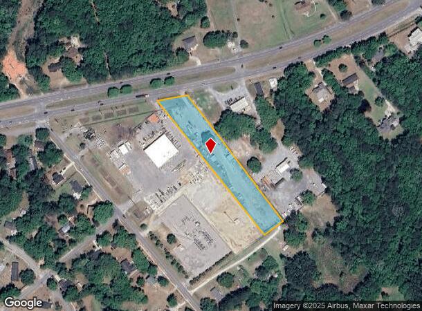
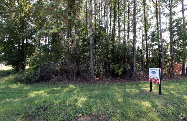
Property Record
3759 N Highway 17, Awendaw, SC 29429

NEARBY LISTINGS FOR SALE OR LEASE
Property Detail
3759 N Highway 17
Charleston-North Charleston, SC
Bee Hive Plantation
614-00-00-143
SUBDIVISION NAME -PART BEE HIVE
Commercialacreage
Charleston
X
South Carolina
45019C0345K
2.10 AC
2025
East Islands/Mt Pleasant
2024
Charleston/N Charleston
004609
DEMOGRAPHICS near 3759 N Highway 17
1 Mile
3 Mile
5 Mile
2024 Total Population
4,656
23,735
43,870
2029 Population
5,001
25,428
46,909
Pop Growth 2024-2029
+ 7.41%
+ 7.13%
+ 6.93%
Average Age
41
41
42
2024 Total Households
1,725
8,788
16,151
HH Growth 2024-2029
+ 7.19%
+ 6.91%
+ 6.79%
Median Household Inc
$99,447
$108,405
$110,124
Avg Household Size
2.70
2.60
2.70
2024 Avg HH Vehicles
2.00
2.00
2.00
Median Home Value
$477,472
$515,585
$505,548
Median Year Built
2001
2007
2004
Nearby Places
Map Layers
Map Styles
 Street
 Aerial
- Restaurants
- Banks
- Shops
- Fitness
- Groceries
PUBLIC TRANSPORTATION
AIRPORT
Charleston AFB/International
DRIVE
WALK
Distance
Charleston AFB/International
36 min
24.0 mi
Freight Ports
Wando Welch Terminal
DRIVE
WALK
Distance
Wando Welch Terminal
14 min
8.7 mi
Nearby Properties
Address
Land Use
TOTAL SIZE
Lot Size
Zoning
Address
Land Use
TOTAL SIZE
Lot Size
Zoning
19.70 AC
Address
Land Use
TOTAL SIZE
Lot Size
Zoning
20.24 AC
Address
Land Use
TOTAL SIZE
Lot Size
Zoning
Address
Land Use
TOTAL SIZE
Lot Size
Zoning
24,836 SF
10.63 AC
Address
Land Use
TOTAL SIZE
Lot Size
Zoning
9.11 AC
Address
Land Use
TOTAL SIZE
Lot Size
Zoning
6,622 SF
20.06 AC
Address
Land Use
TOTAL SIZE
Lot Size
Zoning
3.76 AC
Address
Land Use
TOTAL SIZE
Lot Size
Zoning
2,646 SF
16.35 AC
Address
Land Use
TOTAL SIZE
Lot Size
Zoning
Address
Land Use
TOTAL SIZE
Lot Size
Zoning
Address
Land Use
TOTAL SIZE
Lot Size
Zoning
1,104 SF
13.70 AC
Address
Land Use
TOTAL SIZE
Lot Size
Zoning
5,209 SF
5.88 AC
Address
Land Use
TOTAL SIZE
Lot Size
Zoning
864 SF
22.36 AC
Address
Land Use
TOTAL SIZE
Lot Size
Zoning
12.60 AC
Address
Land Use
TOTAL SIZE
Lot Size
Zoning
30,495 SF
8.73 AC
Address
Land Use
TOTAL SIZE
Lot Size
Zoning
45,969 SF
10.76 AC
Address
Land Use
TOTAL SIZE
Lot Size
Zoning
Address
Land Use
TOTAL SIZE
Lot Size
Zoning
Address
Land Use
TOTAL SIZE
Lot Size
Zoning
Address
Land Use
TOTAL SIZE
Lot Size
Zoning
9.81 AC
Address
Land Use
TOTAL SIZE
Lot Size
Zoning
38,788 SF
10.28 AC
Address
Land Use
TOTAL SIZE
Lot Size
Zoning
Address
Land Use
TOTAL SIZE
Lot Size
Zoning
1,910 SF
7.59 AC
Address
Land Use
TOTAL SIZE
Lot Size
Zoning
8,080 SF
8.82 AC
Address
Land Use
TOTAL SIZE
Lot Size
Zoning
Address
Land Use
TOTAL SIZE
Lot Size
Zoning
5.69 AC
Address
Land Use
TOTAL SIZE
Lot Size
Zoning
60.82 AC
Address
Land Use
TOTAL SIZE
Lot Size
Zoning
55.23 AC
Address
Land Use
TOTAL SIZE
Lot Size
Zoning
1,020 SF
7.40 AC
Address
Land Use
TOTAL SIZE
Lot Size
Zoning
7,552 SF
2.84 AC
The World's #1 Commercial Real Estate Marketplace
Connect with us
© 2025 CoStar Group
The information above has been obtained from sources believed reliable. While we do not doubt its accuracy we have not verified it and make no guarantee, warranty or representation about it. It is your responsibility to independently confirm its accuracy and completeness. Any projections, opinions, assumptions, or estimates used are for example only and do not represent the current or future performance of the property. The value of this transaction to you depends on tax and other factors which should be evaluated by your tax, financial, and legal advisors. You and your advisors should conduct a careful, independent investigation of the property to determine to your satisfaction the suitability of the property for your needs.