Property Record
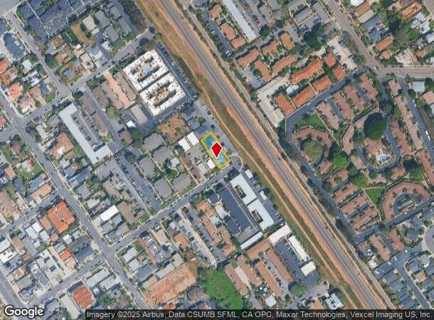
376 Acacia Ave, Carlsbad, CA 92008
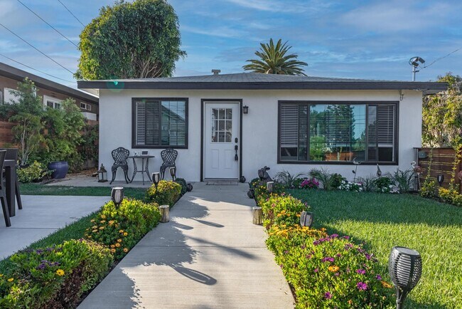

This Property Is For Sale
NEARBY LISTINGS FOR SALE OR LEASE
Property Detail
376 Acacia Ave
San Diego-Carlsbad, CA
Palisades
204-150-15
BLK P LOT 20 POR TR 001747
Multifamilydwelling
San Diego
X
California
06073C0763H
20
2024
0.20 AC
2025
Carlsbad
018000
San Diego
1,522 SF
DEMOGRAPHICS near 376 Acacia Ave
1 Mile
3 Mile
5 Mile
2024 Total Population
13,392
60,041
163,561
2029 Population
13,711
60,696
165,389
Pop Growth 2024-2029
+ 2.38%
+ 1.09%
+ 1.12%
Average Age
42
42
42
2024 Total Households
6,147
24,871
64,050
HH Growth 2024-2029
+ 2.46%
+ 1.13%
+ 1.24%
Median Household Inc
$91,082
$109,394
$100,621
Avg Household Size
2.10
2.40
2.40
2024 Avg HH Vehicles
2.00
2.00
2.00
Median Home Value
$1,079,074
$1,063,852
$951,443
Median Year Built
1977
1979
1982
Nearby Places
Map Layers
Map Styles
 Street
 Aerial
- Restaurants
- Banks
- Shops
- Fitness
- Groceries
PUBLIC TRANSPORTATION
COMMUTER RAIL
Carlsbad Village (Coaster - San Diego North County Transit District (Coaster/Sprinter/Breeze))
DRIVE
WALK
Distance
Carlsbad Village (Coaster - San Diego North County Transit District (Coaster/Sprinter/Breeze))
4 min
19 min
1.0 mi
Oceanside Transit Center (Metrolink Inland Empire-Orange County Line - Metrolink Trains, Metrolink Orange County Line - Metrolink Trains, Orange County Line - Metrolink Trains)
DRIVE
WALK
Distance
Oceanside Transit Center (Metrolink Inland Empire-Orange County Line - Metrolink Trains, Metrolink Orange County Line - Metrolink Trains, Orange County Line - Metrolink Trains)
11 min
4.0 mi
Freight Ports
Port of San Diego
DRIVE
WALK
Distance
Port of San Diego
47 min
36.9 mi
Nearby Properties
Address
Land Use
TOTAL SIZE
Lot Size
Zoning
Address
Land Use
TOTAL SIZE
Lot Size
Zoning
59,518 SF
5.70 AC
P-U
Address
Land Use
TOTAL SIZE
Lot Size
Zoning
132.11 AC
C-T-Q
Address
Land Use
TOTAL SIZE
Lot Size
Zoning
26.65 AC
C-2-Q
Address
Land Use
TOTAL SIZE
Lot Size
Zoning
12.71 AC
P-M
Address
Land Use
TOTAL SIZE
Lot Size
Zoning
16 AC
P-C
Address
Land Use
TOTAL SIZE
Lot Size
Zoning
16.79 AC
R-3-Q
Address
Land Use
TOTAL SIZE
Lot Size
Zoning
9.65 AC
P-C
Address
Land Use
TOTAL SIZE
Lot Size
Zoning
4.26 AC
C-2
Address
Land Use
TOTAL SIZE
Lot Size
Zoning
9.69 AC
C-T-Q
Address
Land Use
TOTAL SIZE
Lot Size
Zoning
20.86 AC
P-M-Q
Address
Land Use
TOTAL SIZE
Lot Size
Zoning
1.77 AC
C-2
Address
Land Use
TOTAL SIZE
Lot Size
Zoning
60.48 AC
OS
Address
Land Use
TOTAL SIZE
Lot Size
Zoning
85,000 SF
4.40 AC
CC
Address
Land Use
TOTAL SIZE
Lot Size
Zoning
19.51 AC
C-2-Q
Address
Land Use
TOTAL SIZE
Lot Size
Zoning
10.63 AC
RD-M
Address
Land Use
TOTAL SIZE
Lot Size
Zoning
2.30 AC
V-R
Address
Land Use
TOTAL SIZE
Lot Size
Zoning
7.38 AC
P-M-Q
Address
Land Use
TOTAL SIZE
Lot Size
Zoning
8.64 AC
R-3-Q
Address
Land Use
TOTAL SIZE
Lot Size
Zoning
95,418 SF
6.51 AC
P-C
Address
Land Use
TOTAL SIZE
Lot Size
Zoning
6.63 AC
RD-M
Address
Land Use
TOTAL SIZE
Lot Size
Zoning
9.76 AC
M
Address
Land Use
TOTAL SIZE
Lot Size
Zoning
57,905 SF
2.16 AC
R-3
Address
Land Use
TOTAL SIZE
Lot Size
Zoning
1.34 AC
V-B
Address
Land Use
TOTAL SIZE
Lot Size
Zoning
6,024 SF
6.92 AC
VC
Address
Land Use
TOTAL SIZE
Lot Size
Zoning
65,359 SF
3.71 AC
C-2-Q
Address
Land Use
TOTAL SIZE
Lot Size
Zoning
81,712 SF
4.70 AC
P-M-Q
Address
Land Use
TOTAL SIZE
Lot Size
Zoning
91,887 SF
1.54 AC
C
Address
Land Use
TOTAL SIZE
Lot Size
Zoning
9.59 AC
RD-M-Q
Address
Land Use
TOTAL SIZE
Lot Size
Zoning
59,587 SF
0.69 AC
V-R
Address
Land Use
TOTAL SIZE
Lot Size
Zoning
84,496 SF
5.09 AC
P-M-Q
The World's #1 Commercial Real Estate Marketplace
Connect with us
© 2025 CoStar Group
The information above has been obtained from sources believed reliable. While we do not doubt its accuracy we have not verified it and make no guarantee, warranty or representation about it. It is your responsibility to independently confirm its accuracy and completeness. Any projections, opinions, assumptions, or estimates used are for example only and do not represent the current or future performance of the property. The value of this transaction to you depends on tax and other factors which should be evaluated by your tax, financial, and legal advisors. You and your advisors should conduct a careful, independent investigation of the property to determine to your satisfaction the suitability of the property for your needs.