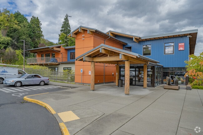
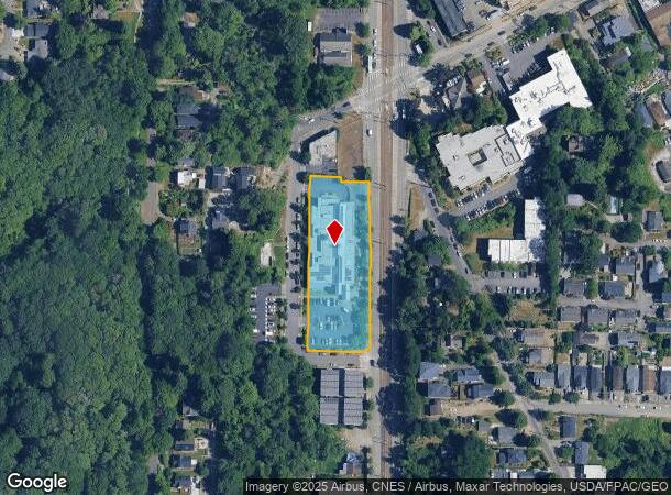
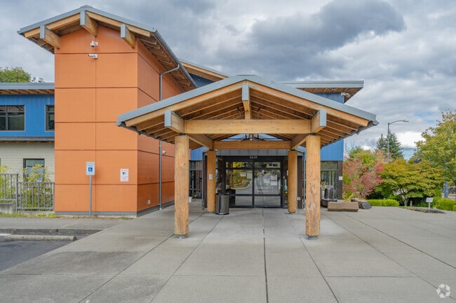
Property Record
3760 Martin Luther King Jr Way S, Seattle, WA 98108
NEARBY LISTINGS FOR SALE OR LEASE
Property Detail
3760 Martin Luther King Jr Way S
Seattle-Tacoma-Bellevue, WA
Cascade View Add
142630-0170
CASCADE VIEW ADD S 20 FT OF 7 ALL OF 8 THRU 33 & 34 LESS N 11 FT OF E 27 FT LESS ST & VAC ALLEY ADJ LESS POR FOR CPSRTA PER SC 03-2-12587-3 SEA DTD 02-25-04 LESS THE SOUTH 1.00 FT OF SD LOTS 20 & 21 AND LESS THE SOUTH 1.00 FT OF ALLEY CONV TO C.O.S.
Officebuilding
King
X
Washington
53033C0635G
7-34
2021
1.39 AC
2024
S Seattle
010900
Seattle/Puget Sound
76,598 SF
DEMOGRAPHICS near 3760 Martin Luther King Jr Way S
1 Mile
3 Mile
5 Mile
2024 Total Population
25,618
138,495
428,573
2029 Population
26,052
141,384
436,142
Pop Growth 2024-2029
+ 1.69%
+ 2.09%
+ 1.77%
Average Age
40
40
39
2024 Total Households
10,151
58,577
207,242
HH Growth 2024-2029
+ 1.59%
+ 2.29%
+ 1.87%
Median Household Inc
$108,612
$95,210
$111,388
Avg Household Size
2.30
2.10
1.90
2024 Avg HH Vehicles
1.00
1.00
1.00
Median Home Value
$830,551
$834,401
$861,987
Median Year Built
1972
1976
1983
Nearby Places
Map Layers
Map Styles
 Street
 Aerial
- Restaurants
- Banks
- Shops
- Fitness
- Groceries
PUBLIC TRANSPORTATION
TRANSIT/SUBWAY
Mount Baker (Central Link - Sound Transit, LINK to Sea-Tac - Sound Transit, Lynnwood - Angle Lake - Sound Transit)
DRIVE
WALK
Distance
Mount Baker (Central Link - Sound Transit, LINK to Sea-Tac - Sound Transit, Lynnwood - Angle Lake - Sound Transit)
2 min
10 min
0.5 mi
St Light Rail & Columbia City Station (Nb) (LINK to Sea-Tac - Central Puget Sound Regional Transit Authority Rail (Link Light Rail/Sounder))
DRIVE
WALK
Distance
St Light Rail & Columbia City Station (Nb) (LINK to Sea-Tac - Central Puget Sound Regional Transit Authority Rail (Link Light Rail/Sounder))
3 min
15 min
0.8 mi
Columbia City (Central Link - Central Puget Sound Regional Transit Authority Rail (Link Light Rail/Sounder))
DRIVE
WALK
Distance
Columbia City (Central Link - Central Puget Sound Regional Transit Authority Rail (Link Light Rail/Sounder))
2 min
15 min
0.8 mi
St Light Rail & Columbia City Station (Sb) (LINK to Sea-Tac - Sound Transit, Lynnwood - Angle Lake - Sound Transit)
DRIVE
WALK
Distance
St Light Rail & Columbia City Station (Sb) (LINK to Sea-Tac - Sound Transit, Lynnwood - Angle Lake - Sound Transit)
2 min
17 min
0.9 mi
COMMUTER RAIL
King Street (Seattle) Station (Everett - Seattle - Sound Transit, Seattle - Tacoma/Lakewood - Sound Transit, Sounder South Line - Sound Transit)
DRIVE
WALK
Distance
King Street (Seattle) Station (Everett - Seattle - Sound Transit, Seattle - Tacoma/Lakewood - Sound Transit, Sounder South Line - Sound Transit)
9 min
2.8 mi
AIRPORT
Seattle-Tacoma International
DRIVE
WALK
Distance
Seattle-Tacoma International
24 min
13.0 mi
Seattle Paine Field International
DRIVE
WALK
Distance
Seattle Paine Field International
41 min
27.4 mi
Freight Ports
Port of Seattle
DRIVE
WALK
Distance
Port of Seattle
10 min
3.5 mi
Nearby Properties
Address
Land Use
TOTAL SIZE
Lot Size
Zoning
Address
Land Use
TOTAL SIZE
Lot Size
Zoning
793,990 SF
30.81 AC
UI U/85
Address
Land Use
TOTAL SIZE
Lot Size
Zoning
992,925 SF
4.28 AC
MIO-240-HR
Address
Land Use
TOTAL SIZE
Lot Size
Zoning
1,526,621 SF
1.36 AC
DOC1 U/450
Address
Land Use
TOTAL SIZE
Lot Size
Zoning
7,930 SF
4.14 AC
MIO-240-HR
Address
Land Use
TOTAL SIZE
Lot Size
Zoning
6,379 SF
127.60 AC
MML U/85
Address
Land Use
TOTAL SIZE
Lot Size
Zoning
30,290 SF
564.80 AC
MML U/85
Address
Land Use
TOTAL SIZE
Lot Size
Zoning
861,221 SF
1.30 AC
DMC 340/29
Address
Land Use
TOTAL SIZE
Lot Size
Zoning
1,011,547 SF
0.35 AC
DOC1 U/450
Address
Land Use
TOTAL SIZE
Lot Size
Zoning
412,000 SF
1.27 AC
DOC1 U/450
Address
Land Use
TOTAL SIZE
Lot Size
Zoning
540,360 SF
1.31 AC
DMC 340/29
Address
Land Use
TOTAL SIZE
Lot Size
Zoning
8,202 SF
1.30 AC
DOC1 U/450
Address
Land Use
TOTAL SIZE
Lot Size
Zoning
914,733 SF
1.41 AC
DOC1 U/450
Address
Land Use
TOTAL SIZE
Lot Size
Zoning
845,533 SF
0.98 AC
DOC1 U/450
Address
Land Use
TOTAL SIZE
Lot Size
Zoning
990,000 SF
0.33 AC
DOC1 U/450
Address
Land Use
TOTAL SIZE
Lot Size
Zoning
726,103 SF
0.17 AC
MIO-240-HR
Address
Land Use
TOTAL SIZE
Lot Size
Zoning
38,770 SF
1.31 AC
DOC1 U/450
Address
Land Use
TOTAL SIZE
Lot Size
Zoning
237,533 SF
8.40 AC
LR3 (M)
Address
Land Use
TOTAL SIZE
Lot Size
Zoning
2,800 SF
210.85 AC
NR1
Address
Land Use
TOTAL SIZE
Lot Size
Zoning
385,274 SF
1.31 AC
DOC1 U/450
Address
Land Use
TOTAL SIZE
Lot Size
Zoning
263,600 SF
5.38 AC
II U/160
Address
Land Use
TOTAL SIZE
Lot Size
Zoning
56,474 SF
99.48 AC
MML U/85
Address
Land Use
TOTAL SIZE
Lot Size
Zoning
504,262 SF
0.73 AC
MIO-70-NC3
Address
Land Use
TOTAL SIZE
Lot Size
Zoning
3,045 SF
86.10 AC
MML U/85
Address
Land Use
TOTAL SIZE
Lot Size
Zoning
459,529 SF
0.37 AC
DOC1 U/450
Address
Land Use
TOTAL SIZE
Lot Size
Zoning
199,530 SF
1.36 AC
DOC1 U/450
Address
Land Use
TOTAL SIZE
Lot Size
Zoning
190,000 SF
1.41 AC
DOC1 U/450
Address
Land Use
TOTAL SIZE
Lot Size
Zoning
680,770 SF
1.50 AC
PSM-85-120
Address
Land Use
TOTAL SIZE
Lot Size
Zoning
427,472 SF
0.50 AC
DOC1 U/450
The World's #1 Commercial Real Estate Marketplace
Connect with us
© 2025 CoStar Group
The information above has been obtained from sources believed reliable. While we do not doubt its accuracy we have not verified it and make no guarantee, warranty or representation about it. It is your responsibility to independently confirm its accuracy and completeness. Any projections, opinions, assumptions, or estimates used are for example only and do not represent the current or future performance of the property. The value of this transaction to you depends on tax and other factors which should be evaluated by your tax, financial, and legal advisors. You and your advisors should conduct a careful, independent investigation of the property to determine to your satisfaction the suitability of the property for your needs.