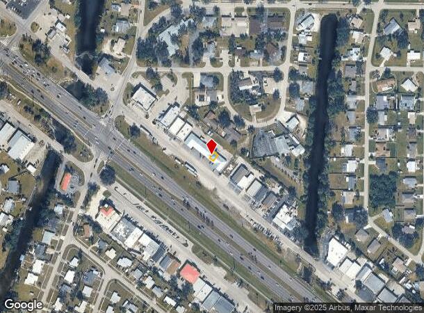
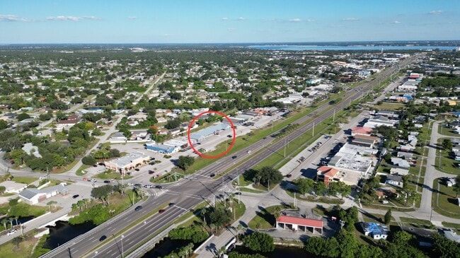
Property Record
3762 Tamiami Trl, Port Charlotte, FL 33952
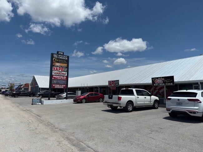
This Property Is For Sale
NEARBY LISTINGS FOR SALE OR LEASE
Property Detail
3762 Tamiami Trl
Punta Gorda, FL
Triwood
402223751006
TRIWOOD UN F PR82-616 1424/908 1607/742 1653/884 FJ2267/465 2814/1604 3238/1375
Storebuilding
Charlotte
AE
Florida
12015C0227G
f
2024
0.11 AC
2025
Charlotte County
020900
Southwest Florida
1,000 SF
DEMOGRAPHICS near 3762 Tamiami Trl
1 Mile
3 Mile
5 Mile
2024 Total Population
9,616
45,263
99,862
2029 Population
11,445
53,849
119,246
Pop Growth 2024-2029
+ 19.02%
+ 18.97%
+ 19.41%
Average Age
49
49
51
2024 Total Households
4,288
19,911
45,334
HH Growth 2024-2029
+ 19.43%
+ 19.38%
+ 19.79%
Median Household Inc
$45,131
$50,884
$57,140
Avg Household Size
2.10
2.20
2.10
2024 Avg HH Vehicles
1.00
2.00
2.00
Median Home Value
$172,926
$186,984
$242,356
Median Year Built
1974
1979
1985
Nearby Places
- Restaurants
- Banks
- Shops
- Fitness
- Groceries
PUBLIC TRANSPORTATION
AIRPORT
Punta Gorda
DRIVE
WALK
Distance
Punta Gorda
16 min
8.1 mi
Freight Ports
Port Manatee
DRIVE
WALK
Distance
Port Manatee
84 min
66.6 mi
Nearby Properties
Address
Land Use
TOTAL SIZE
Lot Size
Zoning
Address
Land Use
TOTAL SIZE
Lot Size
Zoning
333,027 SF
9.79 AC
CHRW
Address
Land Use
TOTAL SIZE
Lot Size
Zoning
156,350 SF
12.49 AC
OMI
Address
Land Use
TOTAL SIZE
Lot Size
Zoning
129,475 SF
16.04 AC
OMI
Address
Land Use
TOTAL SIZE
Lot Size
Zoning
172,298 SF
37.42 AC
OMI
Address
Land Use
TOTAL SIZE
Lot Size
Zoning
789,392 SF
31.39 AC
RMF15
Address
Land Use
TOTAL SIZE
Lot Size
Zoning
139,109 SF
23.44 AC
CG
Address
Land Use
TOTAL SIZE
Lot Size
Zoning
238,852 SF
26.63 AC
CG
Address
Land Use
TOTAL SIZE
Lot Size
Zoning
119,749 SF
12.90 AC
RSF3.5
Address
Land Use
TOTAL SIZE
Lot Size
Zoning
40,430 SF
5.63 AC
RMF12
Address
Land Use
TOTAL SIZE
Lot Size
Zoning
128,594 SF
25.54 AC
PD
Address
Land Use
TOTAL SIZE
Lot Size
Zoning
70,518 SF
2.08 AC
PD
Address
Land Use
TOTAL SIZE
Lot Size
Zoning
102,337 SF
10.43 AC
RSF3.5
Address
Land Use
TOTAL SIZE
Lot Size
Zoning
91,281 SF
10 AC
CG
Address
Land Use
TOTAL SIZE
Lot Size
Zoning
50,970 SF
9.74 AC
RSF3.5
Address
Land Use
TOTAL SIZE
Lot Size
Zoning
12,101 SF
15.92 AC
ES
Address
Land Use
TOTAL SIZE
Lot Size
Zoning
1,296 SF
14.46 AC
CG
Address
Land Use
TOTAL SIZE
Lot Size
Zoning
34,975 SF
2.90 AC
RMF15
Address
Land Use
TOTAL SIZE
Lot Size
Zoning
35,587 SF
6.27 AC
RMF15
Address
Land Use
TOTAL SIZE
Lot Size
Zoning
81,167 SF
5.63 AC
CG
Address
Land Use
TOTAL SIZE
Lot Size
Zoning
448 SF
16.37 AC
PD
Address
Land Use
TOTAL SIZE
Lot Size
Zoning
33,093 SF
1.95 AC
PD
Address
Land Use
TOTAL SIZE
Lot Size
Zoning
82,865 SF
19.74 AC
RMF12
Address
Land Use
TOTAL SIZE
Lot Size
Zoning
11.50 AC
CHRW
Address
Land Use
TOTAL SIZE
Lot Size
Zoning
88,721 SF
7.77 AC
CG
Address
Land Use
TOTAL SIZE
Lot Size
Zoning
12,039 SF
1.69 AC
PD
Address
Land Use
TOTAL SIZE
Lot Size
Zoning
55,843 SF
6.57 AC
CG
Address
Land Use
TOTAL SIZE
Lot Size
Zoning
36,771 SF
5.04 AC
CG
Address
Land Use
TOTAL SIZE
Lot Size
Zoning
76,976 SF
10.95 AC
RSF3.5
Address
Land Use
TOTAL SIZE
Lot Size
Zoning
51,248 SF
15.96 AC
PD
Address
Land Use
TOTAL SIZE
Lot Size
Zoning
21.61 AC
PD
The World's #1 Commercial Real Estate Marketplace
Connect with us
© 2025 CoStar Group
The information above has been obtained from sources believed reliable. While we do not doubt its accuracy we have not verified it and make no guarantee, warranty or representation about it. It is your responsibility to independently confirm its accuracy and completeness. Any projections, opinions, assumptions, or estimates used are for example only and do not represent the current or future performance of the property. The value of this transaction to you depends on tax and other factors which should be evaluated by your tax, financial, and legal advisors. You and your advisors should conduct a careful, independent investigation of the property to determine to your satisfaction the suitability of the property for your needs.