Property Record
377 Keahole St, Honolulu, HI 96825


NEARBY LISTINGS FOR SALE OR LEASE
-
-
View all Honolulu listings for sale on LoopNet.com
Property Detail
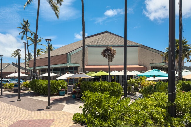
377 Keahole St
Urban Honolulu, HI
Maunalua
1-3-9-008-021-0000
LOT 3 MARINA BUSINESS CENTER NO. 1-A WATER WAY LOTS FP 1776 27,381 SF
Commercialnec
Honolulu
AE
Hawaii
15003C0391G
3
2024
0.63 AC
2025
East Oahu
000108
Hawaii
10,472 SF
DEMOGRAPHICS near 377 Keahole St
1 Mile
3 Mile
5 Mile
2024 Total Population
18,209
39,526
59,991
2029 Population
18,089
38,840
58,439
Pop Growth 2024-2029
(0.66%)
(1.74%)
(2.59%)
Average Age
47
47
46
2024 Total Households
6,732
13,791
19,998
HH Growth 2024-2029
(1.46%)
(2.59%)
(3.35%)
Median Household Inc
$133,253
$139,509
$140,276
Avg Household Size
2.60
2.70
2.80
2024 Avg HH Vehicles
2.00
2.00
2.00
Median Home Value
$924,488
$1,002,775
$1,021,052
Median Year Built
1975
1975
1974
Nearby Places
Map Layers
Map Styles
 Street
 Aerial
- Restaurants
- Banks
- Shops
- Fitness
- Groceries
PUBLIC TRANSPORTATION
AIRPORT
Daniel K Inouye International
DRIVE
WALK
Distance
Daniel K Inouye International
31 min
16.3 mi
Freight Ports
Honolulu Harbor, Oahu
DRIVE
WALK
Distance
Honolulu Harbor, Oahu
33 min
16.2 mi
Nearby Properties
Address
Land Use
TOTAL SIZE
Lot Size
Zoning
Address
Land Use
TOTAL SIZE
Lot Size
Zoning
273,371 SF
11.71 AC
B-2
Address
Land Use
TOTAL SIZE
Lot Size
Zoning
64,703 SF
4.70 AC
B-1
Address
Land Use
TOTAL SIZE
Lot Size
Zoning
146,113 SF
8.45 AC
B-2
Address
Land Use
TOTAL SIZE
Lot Size
Zoning
39,551 SF
B-1
Address
Land Use
TOTAL SIZE
Lot Size
Zoning
38,257 SF
5.91 AC
B-2
Address
Land Use
TOTAL SIZE
Lot Size
Zoning
3,771 SF
5.68 AC
B-2
Address
Land Use
TOTAL SIZE
Lot Size
Zoning
58,646 SF
2.27 AC
B-2
Address
Land Use
TOTAL SIZE
Lot Size
Zoning
4.05 AC
B-2
Address
Land Use
TOTAL SIZE
Lot Size
Zoning
54,057 SF
1.70 AC
B-2
Address
Land Use
TOTAL SIZE
Lot Size
Zoning
102,656 SF
1.15 AC
B-2
Address
Land Use
TOTAL SIZE
Lot Size
Zoning
14.19 AC
R-5
Address
Land Use
TOTAL SIZE
Lot Size
Zoning
91,000 SF
1.29 AC
B-2
Address
Land Use
TOTAL SIZE
Lot Size
Zoning
3.20 AC
B-2
Address
Land Use
TOTAL SIZE
Lot Size
Zoning
43,438 SF
1.07 AC
B-2
Address
Land Use
TOTAL SIZE
Lot Size
Zoning
34,516 SF
1.53 AC
B-2
Address
Land Use
TOTAL SIZE
Lot Size
Zoning
36,471 SF
1.56 AC
B-2
Address
Land Use
TOTAL SIZE
Lot Size
Zoning
19,800 SF
3.87 AC
B-1
Address
Land Use
TOTAL SIZE
Lot Size
Zoning
508.76 AC
P-1
Address
Land Use
TOTAL SIZE
Lot Size
Zoning
2.24 AC
B-2
Address
Land Use
TOTAL SIZE
Lot Size
Zoning
12,288 SF
1.19 AC
B-2
Address
Land Use
TOTAL SIZE
Lot Size
Zoning
24,758 SF
1.06 AC
B-2
Address
Land Use
TOTAL SIZE
Lot Size
Zoning
15,991 SF
54.86 AC
P-2
Address
Land Use
TOTAL SIZE
Lot Size
Zoning
2.46 AC
B-1
Address
Land Use
TOTAL SIZE
Lot Size
Zoning
139.12 AC
AG-2
Address
Land Use
TOTAL SIZE
Lot Size
Zoning
2.21 AC
R-5
Address
Land Use
TOTAL SIZE
Lot Size
Zoning
1,056 SF
709.06 AC
P-1
Address
Land Use
TOTAL SIZE
Lot Size
Zoning
62.33 AC
P-2
Address
Land Use
TOTAL SIZE
Lot Size
Zoning
27,077 SF
0.54 AC
B-2
Address
Land Use
TOTAL SIZE
Lot Size
Zoning
112.04 AC
P-1
The World's #1 Commercial Real Estate Marketplace
Connect with us
© 2026 CoStar Group
The information above has been obtained from sources believed reliable. While we do not doubt its accuracy we have not verified it and make no guarantee, warranty or representation about it. It is your responsibility to independently confirm its accuracy and completeness. Any projections, opinions, assumptions, or estimates used are for example only and do not represent the current or future performance of the property. The value of this transaction to you depends on tax and other factors which should be evaluated by your tax, financial, and legal advisors. You and your advisors should conduct a careful, independent investigation of the property to determine to your satisfaction the suitability of the property for your needs.