Property Record
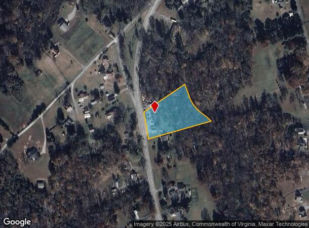
377 S Five Forks Rd, Monroe, VA 24574
NEARBY LISTINGS FOR SALE OR LEASE
-
-
View all Monroe listings for sale on LoopNet.com
Property Detail
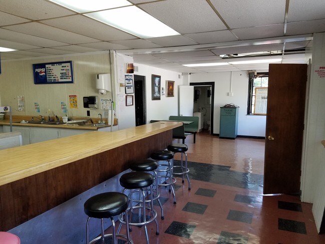
377 S Five Forks Rd
Lynchburg, VA
C M Ferguson Prop
137C1-2-1,6
LOTS 1-6 NEAR FIVE FORKS SERVICE STATION 137C1 2 1-6
Conveniencestore
Amherst
X
Virginia
51009C0290C
1-6
2024
1.62 AC
2025
Lynchburg
010401
Other Market Areas
3,444 SF
DEMOGRAPHICS near 377 S Five Forks Rd
1 Mile
3 Mile
5 Mile
2024 Total Population
728
5,775
14,673
2029 Population
739
5,858
14,889
Pop Growth 2024-2029
+ 1.51%
+ 1.44%
+ 1.47%
Average Age
42
42
42
2024 Total Households
293
2,348
5,919
HH Growth 2024-2029
+ 1.37%
+ 1.45%
+ 1.49%
Median Household Inc
$63,088
$60,989
$64,823
Avg Household Size
2.50
2.40
2.40
2024 Avg HH Vehicles
2.00
2.00
2.00
Median Home Value
$173,417
$171,216
$175,876
Median Year Built
1977
1976
1978
Nearby Places
- Restaurants
- Banks
- Shops
- Fitness
- Groceries
PUBLIC TRANSPORTATION
COMMUTER RAIL
Lynchburg (Crescent - Amtrak, Northeast Regional - Amtrak)
DRIVE
WALK
Distance
Lynchburg (Crescent - Amtrak, Northeast Regional - Amtrak)
15 min
9.8 mi
AIRPORT
Lynchburg Regional/Preston Glenn Field
DRIVE
WALK
Distance
Lynchburg Regional/Preston Glenn Field
27 min
17.2 mi
Freight Ports
Virginia Port Authority - Richmond
DRIVE
WALK
Distance
Virginia Port Authority - Richmond
149 min
107.0 mi
SALE & LEASE HISTORY
LISTING DATE
SALE/LEASE

Sep 23, 2016
For Sale
Nearby Properties
Address
Land Use
TOTAL SIZE
Lot Size
Zoning
Address
Land Use
TOTAL SIZE
Lot Size
Zoning
22,351 SF
335 AC
A1
Address
Land Use
TOTAL SIZE
Lot Size
Zoning
17,160 SF
1.14 AC
B2
Address
Land Use
TOTAL SIZE
Lot Size
Zoning
70,422 SF
13.95 AC
M1
Address
Land Use
TOTAL SIZE
Lot Size
Zoning
8,966 SF
12.39 AC
A1
Address
Land Use
TOTAL SIZE
Lot Size
Zoning
22,161 SF
15.26 AC
B2
Address
Land Use
TOTAL SIZE
Lot Size
Zoning
7,680 SF
4.15 AC
B2
Address
Land Use
TOTAL SIZE
Lot Size
Zoning
12,390 SF
1.56 AC
R2
Address
Land Use
TOTAL SIZE
Lot Size
Zoning
6,000 SF
4.07 AC
R2
Address
Land Use
TOTAL SIZE
Lot Size
Zoning
9,624 SF
3.71 AC
A1
Address
Land Use
TOTAL SIZE
Lot Size
Zoning
5,850 SF
19.19 AC
R2
Address
Land Use
TOTAL SIZE
Lot Size
Zoning
14,021 SF
1.73 AC
B2
Address
Land Use
TOTAL SIZE
Lot Size
Zoning
4,616 SF
3.78 AC
B2
Address
Land Use
TOTAL SIZE
Lot Size
Zoning
13,020 SF
3.34 AC
P1
Address
Land Use
TOTAL SIZE
Lot Size
Zoning
1,485 SF
25.70 AC
B2
Address
Land Use
TOTAL SIZE
Lot Size
Zoning
3,420 SF
1.42 AC
R2
Address
Land Use
TOTAL SIZE
Lot Size
Zoning
2,852 SF
1.05 AC
B2
Address
Land Use
TOTAL SIZE
Lot Size
Zoning
4,676 SF
5.30 AC
R1
Address
Land Use
TOTAL SIZE
Lot Size
Zoning
4,548 SF
2.75 AC
R2
Address
Land Use
TOTAL SIZE
Lot Size
Zoning
11,445 SF
4.51 AC
B2
Address
Land Use
TOTAL SIZE
Lot Size
Zoning
16,000 SF
2.52 AC
B2R2
Address
Land Use
TOTAL SIZE
Lot Size
Zoning
3,664 SF
11.50 AC
B2
Address
Land Use
TOTAL SIZE
Lot Size
Zoning
4,136 SF
2.34 AC
B2
Address
Land Use
TOTAL SIZE
Lot Size
Zoning
4,130 SF
1.92 AC
B2
Address
Land Use
TOTAL SIZE
Lot Size
Zoning
4,000 SF
0.69 AC
B2
Address
Land Use
TOTAL SIZE
Lot Size
Zoning
880 SF
3.79 AC
B2
The World's #1 Commercial Real Estate Marketplace
Connect with us
© 2025 CoStar Group
The information above has been obtained from sources believed reliable. While we do not doubt its accuracy we have not verified it and make no guarantee, warranty or representation about it. It is your responsibility to independently confirm its accuracy and completeness. Any projections, opinions, assumptions, or estimates used are for example only and do not represent the current or future performance of the property. The value of this transaction to you depends on tax and other factors which should be evaluated by your tax, financial, and legal advisors. You and your advisors should conduct a careful, independent investigation of the property to determine to your satisfaction the suitability of the property for your needs.