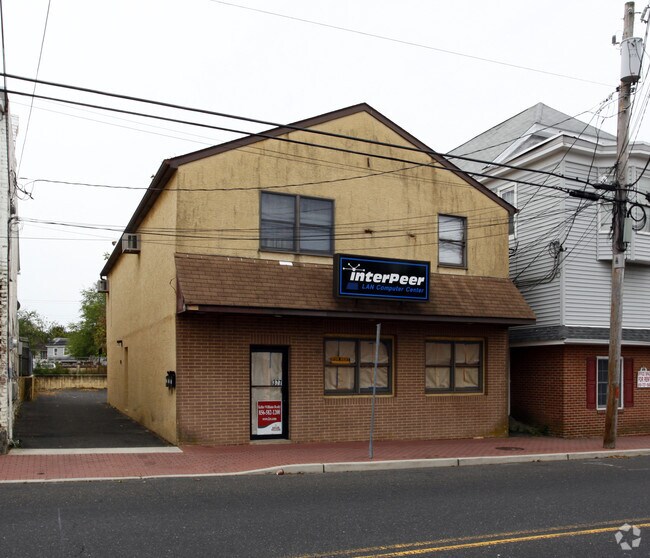
Property Record
377 S Main St, Williamstown, NJ 08094

Property Detail
377 S Main St
11-11702-0000-00007
Gloucester
Apartment
New Jersey
RGTC
7
B and X Area of moderate flood hazard, usually the area between the limits of the 100-year and 500-year floods.
0.11 AC
2024
Gloucester County
2025
Philadelphia
501604
Philadelphia-Camden-Wilmington, PA-NJ-DE-MD
3,300 SF
NEARBY LISTINGS FOR SALE OR LEASE
DEMOGRAPHICS near 377 S Main St
1 mile
3 mile
5 mile
2025 Total Population
9,448
43,020
89,018
2030 Population
9,717
44,340
91,501
Pop Growth 2025-2030
+ 2.85%
+ 3.07%
+ 2.79%
Average Age
40
40
41
2025 Total Households
3,483
15,708
31,938
HH Growth 2025-2030
+ 2.87%
+ 3.13%
+ 2.86%
Median Household Inc
$84,311
$89,160
$95,821
Avg Household Size
2.70
2.70
2.70
2025 Avg HH Vehicles
2.00
2.00
2.00
Median Home Value
$279,874
$281,910
$313,167
Median Year Built
1975
1984
1987
Nearby Places
Map Layers
Map Styles
 Street
 Aerial
Layers
 Traffic
 Biking
Places
Listings with unknown addresses are not visible on the map
- Restaurants
- Banks
- Shops
- Fitness
- Groceries
PUBLIC TRANSPORTATION
COMMUTER RAIL
Atco (Atlantic City Line - NJ Transit Commuter Rail (NJ Transit))
Drive
Walk
Distance
Atco (Atlantic City Line - NJ Transit Commuter Rail (NJ Transit))
15 min
8.8 mi
AIRPORT
Philadelphia International
Drive
Walk
Distance
Philadelphia International
44 min
28.0 mi
Atlantic City International
Drive
Walk
Distance
Atlantic City International
62 min
34.6 mi
Freight Ports
Broadway Terminal - Pier 5
Drive
Walk
Distance
Broadway Terminal - Pier 5
28 min
19.5 mi
Nearby Properties
Address
Land Use
TOTAL SIZE
Lot Size
Zoning
Address
Land Use
TOTAL SIZE
Lot Size
Zoning
46.45 AC
RGMR
Address
Land Use
TOTAL SIZE
Lot Size
Zoning
74.69 AC
RGMR
Address
Land Use
TOTAL SIZE
Lot Size
Zoning
25.89 AC
RGPR
Address
Land Use
TOTAL SIZE
Lot Size
Zoning
19.53 AC
R2
Address
Land Use
TOTAL SIZE
Lot Size
Zoning
35.07 AC
Address
Land Use
TOTAL SIZE
Lot Size
Zoning
1 SF
19.71 AC
CC
Address
Land Use
TOTAL SIZE
Lot Size
Zoning
9.76 AC
R2
Address
Land Use
TOTAL SIZE
Lot Size
Zoning
29.50 AC
FD10
Address
Land Use
TOTAL SIZE
Lot Size
Zoning
7.69 AC
RG30
Address
Land Use
TOTAL SIZE
Lot Size
Zoning
3.44 AC
RM
Address
Land Use
TOTAL SIZE
Lot Size
Zoning
13.03 AC
RL
Address
Land Use
TOTAL SIZE
Lot Size
Zoning
10.98 AC
RGPR
Address
Land Use
TOTAL SIZE
Lot Size
Zoning
11.46 AC
RGPR
Address
Land Use
TOTAL SIZE
Lot Size
Zoning
2.80 AC
RG30
Address
Land Use
TOTAL SIZE
Lot Size
Zoning
6.51 AC
C
Address
Land Use
TOTAL SIZE
Lot Size
Zoning
12.20 AC
CC
Address
Land Use
TOTAL SIZE
Lot Size
Zoning
0.92 AC
RGTC
Address
Land Use
TOTAL SIZE
Lot Size
Zoning
54,056 SF
17.26 AC
P
Address
Land Use
TOTAL SIZE
Lot Size
Zoning
4.06 AC
RG40
Address
Land Use
TOTAL SIZE
Lot Size
Zoning
Address
Land Use
TOTAL SIZE
Lot Size
Zoning
5.30 AC
RGPR
Address
Land Use
TOTAL SIZE
Lot Size
Zoning
2.13 AC
RGTC
Address
Land Use
TOTAL SIZE
Lot Size
Zoning
26.73 AC
BP
Address
Land Use
TOTAL SIZE
Lot Size
Zoning
Address
Land Use
TOTAL SIZE
Lot Size
Zoning
6.63 AC
RM
Address
Land Use
TOTAL SIZE
Lot Size
Zoning
11.82 AC
RM
Address
Land Use
TOTAL SIZE
Lot Size
Zoning
4.33 AC
C
Address
Land Use
TOTAL SIZE
Lot Size
Zoning
8.41 AC
CM
Address
Land Use
TOTAL SIZE
Lot Size
Zoning
4.97 AC
CC
Address
Land Use
TOTAL SIZE
Lot Size
Zoning
5,464 SF
3.46 AC
C
The World's #1 Commercial Real Estate Marketplace
Connect with us
© 2026 CoStar Group
The information above has been obtained from sources believed reliable. While we do not doubt its accuracy we have not verified it and make no guarantee, warranty or representation about it. It is your responsibility to independently confirm its accuracy and completeness. Any projections, opinions, assumptions, or estimates used are for example only and do not represent the current or future performance of the property. The value of this transaction to you depends on tax and other factors which should be evaluated by your tax, financial, and legal advisors. You and your advisors should conduct a careful, independent investigation of the property to determine to your satisfaction the suitability of the property for your needs.