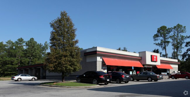
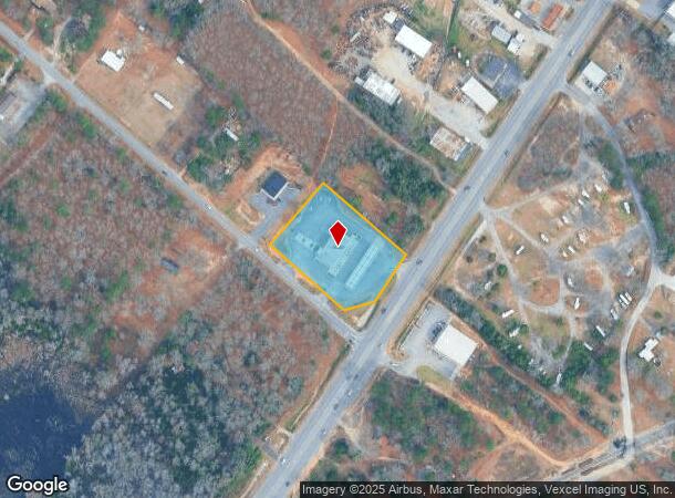
Property Record
3771 Peach Orchard Rd, Augusta, GA 30906
NEARBY LISTINGS FOR SALE OR LEASE
Property Detail
3771 Peach Orchard Rd
1680109010
Claude C Boykin
Commercialacreage
3771 PEACH ORCHARD RD
X
Richmond
13245C0210G
Georgia
2025
1.89 AC
2025
South Richmond County
010710
Augusta/Richmond County
5,238 SF
Augusta-Richmond County, GA-SC
DEMOGRAPHICS near 3771 Peach Orchard Rd
1 mile
3 mile
5 mile
2024 Total Population
3,043
29,458
71,323
2029 Population
3,055
29,189
70,582
Pop Growth 2024-2029
+ 0.39%
(0.91%)
(1.04%)
Average Age
38
38
38
2024 Total Households
1,143
10,921
26,271
HH Growth 2024-2029
+ 0.52%
(0.84%)
(0.95%)
Median Household Inc
$49,999
$55,428
$50,802
Avg Household Size
2.50
2.60
2.60
2024 Avg HH Vehicles
2.00
2.00
2.00
Median Home Value
$99,489
$137,135
$127,790
Median Year Built
1987
1988
1982
Nearby Places
Map Layers
Map Styles
 Street
 Aerial
Transit
 Traffic
 Biking
Places
Listings with unknown addresses are not visible on the map
- Restaurants
- Banks
- Shops
- Fitness
- Groceries
PUBLIC TRANSPORTATION
AIRPORT
Augusta Regional at Bush Field
Drive
Walk
Distance
Augusta Regional at Bush Field
16 min
7.4 mi
SALE & LEASE HISTORY
LISTING DATE
SALE/LEASE

Sep 24, 2016
For Sale
Nearby Properties
Address
Land Use
TOTAL SIZE
Lot Size
Zoning
Address
Land Use
TOTAL SIZE
Lot Size
Zoning
297,455 SF
45.93 AC
A
Address
Land Use
TOTAL SIZE
Lot Size
Zoning
193,026 SF
97.24 AC
R-1
Address
Land Use
TOTAL SIZE
Lot Size
Zoning
99,046 SF
29.96 AC
R-1A
Address
Land Use
TOTAL SIZE
Lot Size
Zoning
87,976 SF
765.88 AC
R-1
Address
Land Use
TOTAL SIZE
Lot Size
Zoning
59,310 SF
43.16 AC
A
Address
Land Use
TOTAL SIZE
Lot Size
Zoning
252,567 SF
27.65 AC
B-2
Address
Land Use
TOTAL SIZE
Lot Size
Zoning
3,387 SF
16.91 AC
B-2
Address
Land Use
TOTAL SIZE
Lot Size
Zoning
18,000 SF
27.80 AC
B-2
Address
Land Use
TOTAL SIZE
Lot Size
Zoning
109,424 SF
24.28 AC
R-1
Address
Land Use
TOTAL SIZE
Lot Size
Zoning
1,080 SF
18.87 AC
R-3B
Address
Land Use
TOTAL SIZE
Lot Size
Zoning
22,080 SF
19.49 AC
R-3B
Address
Land Use
TOTAL SIZE
Lot Size
Zoning
80,038 SF
19.49 AC
R-1A
Address
Land Use
TOTAL SIZE
Lot Size
Zoning
17,202 SF
28.86 AC
B-1
Address
Land Use
TOTAL SIZE
Lot Size
Zoning
298,532 SF
20.39 AC
HI
Address
Land Use
TOTAL SIZE
Lot Size
Zoning
78,454 SF
10.63 AC
B-2
Address
Land Use
TOTAL SIZE
Lot Size
Zoning
67,560 SF
15.97 AC
R-1
Address
Land Use
TOTAL SIZE
Lot Size
Zoning
107,996 SF
9.91 AC
R-3B
Address
Land Use
TOTAL SIZE
Lot Size
Zoning
66,320 SF
14.69 AC
R-1_R-1A
Address
Land Use
TOTAL SIZE
Lot Size
Zoning
33,024 SF
10.64 AC
R-3B
Address
Land Use
TOTAL SIZE
Lot Size
Zoning
10,575 SF
61.57 AC
HI
Address
Land Use
TOTAL SIZE
Lot Size
Zoning
7,800 SF
4.68 AC
B-2
Address
Land Use
TOTAL SIZE
Lot Size
Zoning
961 SF
5.15 AC
B-2
Address
Land Use
TOTAL SIZE
Lot Size
Zoning
1,800 SF
4.30 AC
B-2
Address
Land Use
TOTAL SIZE
Lot Size
Zoning
48,175 SF
6.55 AC
B-2
Address
Land Use
TOTAL SIZE
Lot Size
Zoning
2,356 SF
122.32 AC
A_R-MH
Address
Land Use
TOTAL SIZE
Lot Size
Zoning
56,038 SF
8.01 AC
B-2
Address
Land Use
TOTAL SIZE
Lot Size
Zoning
14,324 SF
9.89 AC
A
Address
Land Use
TOTAL SIZE
Lot Size
Zoning
48,134 SF
6.87 AC
B-2
Address
Land Use
TOTAL SIZE
Lot Size
Zoning
73,186 SF
15.74 AC
HI
Address
Land Use
TOTAL SIZE
Lot Size
Zoning
2,600 SF
46.39 AC
A,R
The World's #1 Commercial Real Estate Marketplace
Connect with us
© 2026 CoStar Group
The information above has been obtained from sources believed reliable. While we do not doubt its accuracy we have not verified it and make no guarantee, warranty or representation about it. It is your responsibility to independently confirm its accuracy and completeness. Any projections, opinions, assumptions, or estimates used are for example only and do not represent the current or future performance of the property. The value of this transaction to you depends on tax and other factors which should be evaluated by your tax, financial, and legal advisors. You and your advisors should conduct a careful, independent investigation of the property to determine to your satisfaction the suitability of the property for your needs.