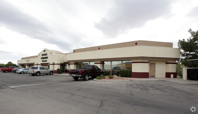
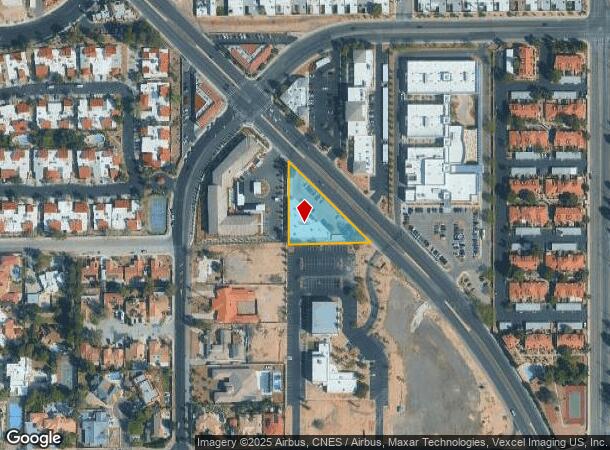
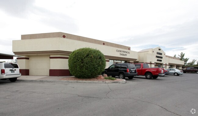
Property Record
3777 Pecos Mcleod, Las Vegas, NV 89121

NEARBY LISTINGS FOR SALE OR LEASE
Property Detail
3777 Pecos Mcleod
162-13-708-002
PT NE4 SE4 SEC 13 21 61
Commercialnec
Clark
X
Nevada
32003C2580F
0.80 AC
2025
Central East Las Vegas
2025
Las Vegas
001709
Las Vegas-Henderson-Paradise, NV
9,473 SF
DEMOGRAPHICS near 3777 Pecos Mcleod
1 Mile
3 Mile
5 Mile
2024 Total Population
17,892
211,020
474,667
2029 Population
19,143
225,811
508,889
Pop Growth 2024-2029
+ 6.99%
+ 7.01%
+ 7.21%
Average Age
44
39
39
2024 Total Households
7,600
84,813
184,168
HH Growth 2024-2029
+ 6.96%
+ 6.96%
+ 7.32%
Median Household Inc
$54,960
$40,990
$43,777
Avg Household Size
2.30
2.40
2.50
2024 Avg HH Vehicles
2.00
1.00
1.00
Median Home Value
$311,973
$269,933
$280,158
Median Year Built
1978
1978
1985
Nearby Places
Map Layers
Map Styles
 Street
 Aerial
- Restaurants
- Banks
- Shops
- Fitness
- Groceries
PUBLIC TRANSPORTATION
AIRPORT
Harry Reid International
DRIVE
WALK
Distance
Harry Reid International
10 min
5.6 mi
Boulder City Municipal
DRIVE
WALK
Distance
Boulder City Municipal
29 min
21.1 mi
Freight Ports
Port of Long Beach
DRIVE
WALK
Distance
Port of Long Beach
319 min
281.7 mi
SALE & LEASE HISTORY
LISTING DATE
SALE/LEASE

Sep 13, 2019
For Lease
Nearby Properties
Address
Land Use
TOTAL SIZE
Lot Size
Zoning
Address
Land Use
TOTAL SIZE
Lot Size
Zoning
323,696 SF
24.62 AC
H1
Address
Land Use
TOTAL SIZE
Lot Size
Zoning
524,471 SF
59.01 AC
Address
Land Use
TOTAL SIZE
Lot Size
Zoning
48.58 AC
PF
Address
Land Use
TOTAL SIZE
Lot Size
Zoning
265,609 SF
47.36 AC
H1
Address
Land Use
TOTAL SIZE
Lot Size
Zoning
138.07 AC
PF
Address
Land Use
TOTAL SIZE
Lot Size
Zoning
281,120 SF
21.38 AC
Address
Land Use
TOTAL SIZE
Lot Size
Zoning
345,133 SF
27.01 AC
H1
Address
Land Use
TOTAL SIZE
Lot Size
Zoning
9.01 AC
PF
Address
Land Use
TOTAL SIZE
Lot Size
Zoning
157,191 SF
5.97 AC
Address
Land Use
TOTAL SIZE
Lot Size
Zoning
44.69 AC
PF
Address
Land Use
TOTAL SIZE
Lot Size
Zoning
549,077 SF
2.90 AC
H1
Address
Land Use
TOTAL SIZE
Lot Size
Zoning
72.03 AC
PF
Address
Land Use
TOTAL SIZE
Lot Size
Zoning
709,943 SF
43.10 AC
C2
Address
Land Use
TOTAL SIZE
Lot Size
Zoning
6,396 SF
15.06 AC
Address
Land Use
TOTAL SIZE
Lot Size
Zoning
19,781 SF
5.07 AC
Address
Land Use
TOTAL SIZE
Lot Size
Zoning
8,611 SF
10 AC
H1
Address
Land Use
TOTAL SIZE
Lot Size
Zoning
95,928 SF
3.71 AC
C:U-V
Address
Land Use
TOTAL SIZE
Lot Size
Zoning
239,785 SF
2.20 AC
C:R-5
Address
Land Use
TOTAL SIZE
Lot Size
Zoning
513,085 SF
53.27 AC
C2
Address
Land Use
TOTAL SIZE
Lot Size
Zoning
38,764 SF
12.66 AC
H1
Address
Land Use
TOTAL SIZE
Lot Size
Zoning
5.39 AC
Address
Land Use
TOTAL SIZE
Lot Size
Zoning
4,460 SF
27.52 AC
Address
Land Use
TOTAL SIZE
Lot Size
Zoning
15.95 AC
PF
Address
Land Use
TOTAL SIZE
Lot Size
Zoning
11.18 AC
PF
Address
Land Use
TOTAL SIZE
Lot Size
Zoning
225,097 SF
3.24 AC
H1
Address
Land Use
TOTAL SIZE
Lot Size
Zoning
12,216 SF
15.69 AC
PF
Address
Land Use
TOTAL SIZE
Lot Size
Zoning
56,526 SF
12.44 AC
C2
Address
Land Use
TOTAL SIZE
Lot Size
Zoning
170,395 SF
2.26 AC
H1
Address
Land Use
TOTAL SIZE
Lot Size
Zoning
5,649 SF
15.32 AC
R4
Address
Land Use
TOTAL SIZE
Lot Size
Zoning
6,659 SF
6.05 AC
H1
The World's #1 Commercial Real Estate Marketplace
Connect with us
© 2025 CoStar Group
The information above has been obtained from sources believed reliable. While we do not doubt its accuracy we have not verified it and make no guarantee, warranty or representation about it. It is your responsibility to independently confirm its accuracy and completeness. Any projections, opinions, assumptions, or estimates used are for example only and do not represent the current or future performance of the property. The value of this transaction to you depends on tax and other factors which should be evaluated by your tax, financial, and legal advisors. You and your advisors should conduct a careful, independent investigation of the property to determine to your satisfaction the suitability of the property for your needs.