Property Record
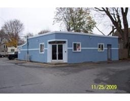
378 Ocean Grove Ave, Swansea, MA 02777


NEARBY LISTINGS FOR SALE OR LEASE
Property Detail
378 Ocean Grove Ave
Commercialofficeresidentialmixeduse
Bristol
X
Massachusetts
25005C0327G
0.14 AC
0
Attleboro/New Bedford
2025
Boston
645101
Providence-Warwick, RI-MA
1,906 SF
SWAN-000480-000063
DEMOGRAPHICS near 378 Ocean Grove Ave
1 Mile
3 Mile
5 Mile
2024 Total Population
5,485
30,136
158,647
2029 Population
5,479
30,045
157,641
Pop Growth 2024-2029
(0.11%)
(0.30%)
(0.63%)
Average Age
45
44
42
2024 Total Households
2,312
12,256
66,888
HH Growth 2024-2029
(0.17%)
(0.35%)
(0.66%)
Median Household Inc
$74,853
$89,881
$65,572
Avg Household Size
2.30
2.40
2.30
2024 Avg HH Vehicles
2.00
2.00
2.00
Median Home Value
$319,551
$377,990
$373,069
Median Year Built
1952
1963
1953
Nearby Places
Map Layers
Map Styles
 Street
 Aerial
- Restaurants
- Banks
- Shops
- Fitness
- Groceries
PUBLIC TRANSPORTATION
AIRPORT
Rhode Island Tf Green International
DRIVE
WALK
Distance
Rhode Island Tf Green International
38 min
22.9 mi
SALE & LEASE HISTORY
LISTING DATE
SALE/LEASE

Sep 23, 2016
For Sale
Apr 03, 2018
For Sale
Nearby Properties
Address
Land Use
TOTAL SIZE
Lot Size
Zoning
Address
Land Use
TOTAL SIZE
Lot Size
Zoning
183,732 SF
5.50 AC
IND
Address
Land Use
TOTAL SIZE
Lot Size
Zoning
105,949 SF
25.21 AC
R1
Address
Land Use
TOTAL SIZE
Lot Size
Zoning
16.08 AC
N/A
Address
Land Use
TOTAL SIZE
Lot Size
Zoning
75,736 SF
1.39 AC
B-L
Address
Land Use
TOTAL SIZE
Lot Size
Zoning
155,364 SF
15.27 AC
C
Address
Land Use
TOTAL SIZE
Lot Size
Zoning
143,084 SF
12.60 AC
R1
Address
Land Use
TOTAL SIZE
Lot Size
Zoning
152,620 SF
20.73 AC
C
Address
Land Use
TOTAL SIZE
Lot Size
Zoning
137,976 SF
10.59 AC
C
Address
Land Use
TOTAL SIZE
Lot Size
Zoning
140,460 SF
12.50 AC
R10
Address
Land Use
TOTAL SIZE
Lot Size
Zoning
114,424 SF
12.94 AC
C
Address
Land Use
TOTAL SIZE
Lot Size
Zoning
99,066 SF
3.05 AC
IND
Address
Land Use
TOTAL SIZE
Lot Size
Zoning
70,741 SF
16.24 AC
Address
Land Use
TOTAL SIZE
Lot Size
Zoning
1.97 AC
R10
Address
Land Use
TOTAL SIZE
Lot Size
Zoning
4.40 AC
B
Address
Land Use
TOTAL SIZE
Lot Size
Zoning
24,480 SF
4.69 AC
C
Address
Land Use
TOTAL SIZE
Lot Size
Zoning
79,105 SF
0.93 AC
N/A
Address
Land Use
TOTAL SIZE
Lot Size
Zoning
223,380 SF
19.03 AC
C
Address
Land Use
TOTAL SIZE
Lot Size
Zoning
51,308 SF
10.34 AC
C
Address
Land Use
TOTAL SIZE
Lot Size
Zoning
68,859 SF
7.07 AC
C
Address
Land Use
TOTAL SIZE
Lot Size
Zoning
177,003 SF
26.96 AC
C
Address
Land Use
TOTAL SIZE
Lot Size
Zoning
58,028 SF
6.61 AC
C
Address
Land Use
TOTAL SIZE
Lot Size
Zoning
91,510 SF
Address
Land Use
TOTAL SIZE
Lot Size
Zoning
29,058 SF
21.97 AC
R40
Address
Land Use
TOTAL SIZE
Lot Size
Zoning
20,187 SF
7.02 AC
C
Address
Land Use
TOTAL SIZE
Lot Size
Zoning
55,600 SF
4.08 AC
C
Address
Land Use
TOTAL SIZE
Lot Size
Zoning
1,800 SF
3.39 AC
R1
Address
Land Use
TOTAL SIZE
Lot Size
Zoning
11,936 SF
14.15 AC
C
Address
Land Use
TOTAL SIZE
Lot Size
Zoning
22,545 SF
7 AC
R1
Address
Land Use
TOTAL SIZE
Lot Size
Zoning
91,235 SF
Address
Land Use
TOTAL SIZE
Lot Size
Zoning
112,123 SF
The World's #1 Commercial Real Estate Marketplace
Connect with us
© 2026 CoStar Group
The information above has been obtained from sources believed reliable. While we do not doubt its accuracy we have not verified it and make no guarantee, warranty or representation about it. It is your responsibility to independently confirm its accuracy and completeness. Any projections, opinions, assumptions, or estimates used are for example only and do not represent the current or future performance of the property. The value of this transaction to you depends on tax and other factors which should be evaluated by your tax, financial, and legal advisors. You and your advisors should conduct a careful, independent investigation of the property to determine to your satisfaction the suitability of the property for your needs.