Property Record
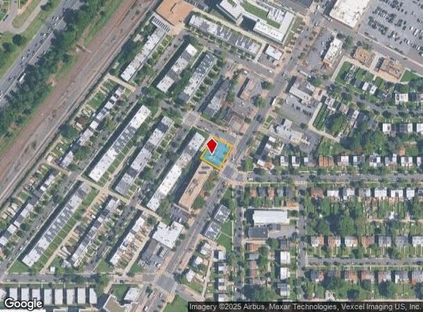
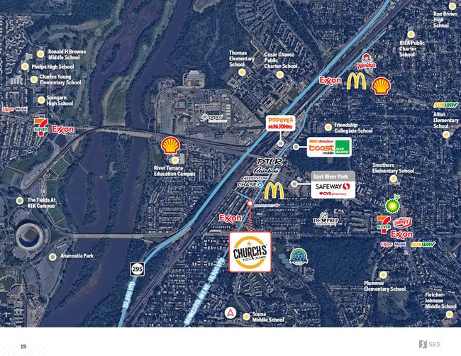
3780 Minnesota Ave Ne, Washington, DC 20019
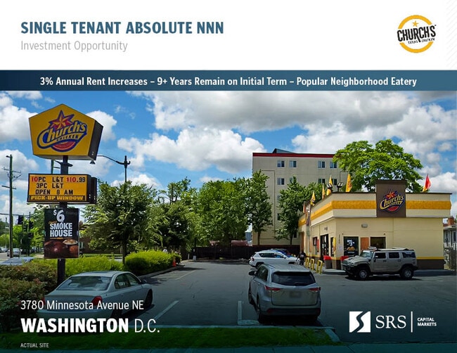
This Property Is For Sale
NEARBY LISTINGS FOR SALE OR LEASE
Property Detail
3780 Minnesota Ave Ne
Washington-Arlington-Alexandria, DC-VA-MD-WV
Deanwood
5046E-0045
SQUARE 5046 SUFFIX E LOT 0045 NBHD: DEANWOOD
Restaurantdrivein
District of Columbia
X
District of Columbia
1100010039C
45
2025
0.23 AC
2025
Northeast
009603
Washington, DC
1,914 SF
DEMOGRAPHICS near 3780 Minnesota Ave Ne
1 Mile
3 Mile
5 Mile
2024 Total Population
25,478
228,975
631,056
2029 Population
23,262
213,054
593,114
Pop Growth 2024-2029
(8.70%)
(6.95%)
(6.01%)
Average Age
38
38
38
2024 Total Households
10,936
97,137
273,327
HH Growth 2024-2029
(9.61%)
(7.74%)
(6.79%)
Median Household Inc
$41,224
$71,858
$79,345
Avg Household Size
2.30
2.20
2.20
2024 Avg HH Vehicles
1.00
1.00
1.00
Median Home Value
$401,044
$466,640
$439,429
Median Year Built
1958
1956
1965
Nearby Places
Map Layers
Map Styles
 Street
 Aerial
- Restaurants
- Banks
- Shops
- Fitness
- Groceries
PUBLIC TRANSPORTATION
TRANSIT/SUBWAY
Minnesota Avenue (Orange Line - Washington Metropolitan Area Transit Authority Metrorail (Metrorail))
DRIVE
WALK
Distance
Minnesota Avenue (Orange Line - Washington Metropolitan Area Transit Authority Metrorail (Metrorail))
3 min
12 min
0.6 mi
Benning Road (Blue Line - Washington Metropolitan Area Transit Authority Metrorail (Metrorail), Silver Line - Washington Metropolitan Area Transit Authority Metrorail (Metrorail))
DRIVE
WALK
Distance
Benning Road (Blue Line - Washington Metropolitan Area Transit Authority Metrorail (Metrorail), Silver Line - Washington Metropolitan Area Transit Authority Metrorail (Metrorail))
2 min
18 min
0.9 mi
COMMUTER RAIL
DRIVE
WALK
Distance
8 min
3.7 mi
Union Station (Red Line - Washington Metropolitan Area Transit Authority Metrorail (Metrorail))
DRIVE
WALK
Distance
Union Station (Red Line - Washington Metropolitan Area Transit Authority Metrorail (Metrorail))
8 min
3.8 mi
AIRPORT
Ronald Reagan Washington Ntl
DRIVE
WALK
Distance
Ronald Reagan Washington Ntl
19 min
8.9 mi
Baltimore/Washington International Thurgood Marshall
DRIVE
WALK
Distance
Baltimore/Washington International Thurgood Marshall
42 min
28.2 mi
Washington Dulles International
DRIVE
WALK
Distance
Washington Dulles International
53 min
32.6 mi
Freight Ports
Port of Baltimore
DRIVE
WALK
Distance
Port of Baltimore
51 min
34.5 mi
Nearby Properties
Address
Land Use
TOTAL SIZE
Lot Size
Zoning
Address
Land Use
TOTAL SIZE
Lot Size
Zoning
58,289 SF
418.97 AC
MU-4;PDR-1
Address
Land Use
TOTAL SIZE
Lot Size
Zoning
2,369,428 SF
7.93 AC
MU-10;SEFC
Address
Land Use
TOTAL SIZE
Lot Size
Zoning
2,058,692 SF
4.77 AC
UNZONED
Address
Land Use
TOTAL SIZE
Lot Size
Zoning
607,735 SF
8.94 AC
PDR-3;UNZO
Address
Land Use
TOTAL SIZE
Lot Size
Zoning
2,542,436 SF
6.39 AC
MU-2;MU-4;
Address
Land Use
TOTAL SIZE
Lot Size
Zoning
1,642,951 SF
95.12 AC
RF-1
Address
Land Use
TOTAL SIZE
Lot Size
Zoning
730,233 SF
4.78 AC
UNZONED
Address
Land Use
TOTAL SIZE
Lot Size
Zoning
1,323,000 SF
3.36 AC
RA-2
Address
Land Use
TOTAL SIZE
Lot Size
Zoning
21.28 AC
GOV
Address
Land Use
TOTAL SIZE
Lot Size
Zoning
169.85 AC
R-2;RA-1;U
Address
Land Use
TOTAL SIZE
Lot Size
Zoning
812,092 SF
10.19 AC
UNZONED
Address
Land Use
TOTAL SIZE
Lot Size
Zoning
726,490 SF
3.84 AC
RA-2
Address
Land Use
TOTAL SIZE
Lot Size
Zoning
572,916 SF
1.26 AC
UNZONED
Address
Land Use
TOTAL SIZE
Lot Size
Zoning
2,131,229 SF
144.34 AC
AG
Address
Land Use
TOTAL SIZE
Lot Size
Zoning
1,059,397 SF
2.51 AC
PDR-3;USN
Address
Land Use
TOTAL SIZE
Lot Size
Zoning
30,000 SF
819.17 AC
PDR-1;RA-1
Address
Land Use
TOTAL SIZE
Lot Size
Zoning
538,974 SF
1.26 AC
PDR-3
Address
Land Use
TOTAL SIZE
Lot Size
Zoning
503,872 SF
1.24 AC
D-5
Address
Land Use
TOTAL SIZE
Lot Size
Zoning
755,499 SF
1.75 AC
PDR-3;USN
Address
Land Use
TOTAL SIZE
Lot Size
Zoning
280,000 SF
D-5
Address
Land Use
TOTAL SIZE
Lot Size
Zoning
418,531 SF
2.48 AC
RF-1
Address
Land Use
TOTAL SIZE
Lot Size
Zoning
407,850 SF
Address
Land Use
TOTAL SIZE
Lot Size
Zoning
36.52 AC
HE-2;HE-3;
Address
Land Use
TOTAL SIZE
Lot Size
Zoning
3.01 AC
UNZONED
Address
Land Use
TOTAL SIZE
Lot Size
Zoning
236,535 SF
12.54 AC
R-2
Address
Land Use
TOTAL SIZE
Lot Size
Zoning
747,331 SF
1.26 AC
PDR-3;USN
Address
Land Use
TOTAL SIZE
Lot Size
Zoning
368,602 SF
1.71 AC
MU-4;NMU-5
Address
Land Use
TOTAL SIZE
Lot Size
Zoning
404,150 SF
1.34 AC
D-5
Address
Land Use
TOTAL SIZE
Lot Size
Zoning
338,258 SF
1.94 AC
PDR-1;PDR-
Address
Land Use
TOTAL SIZE
Lot Size
Zoning
281,204 SF
PDR-1;PDR-
The World's #1 Commercial Real Estate Marketplace
Connect with us
© 2026 CoStar Group
The information above has been obtained from sources believed reliable. While we do not doubt its accuracy we have not verified it and make no guarantee, warranty or representation about it. It is your responsibility to independently confirm its accuracy and completeness. Any projections, opinions, assumptions, or estimates used are for example only and do not represent the current or future performance of the property. The value of this transaction to you depends on tax and other factors which should be evaluated by your tax, financial, and legal advisors. You and your advisors should conduct a careful, independent investigation of the property to determine to your satisfaction the suitability of the property for your needs.