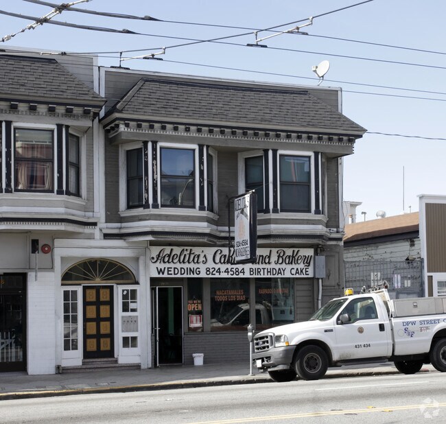
Property Record
3780 Mission St, San Francisco, CA 94110
NEARBY LISTINGS FOR SALE OR LEASE
Property Detail
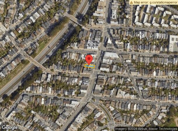
3780 Mission St
San Francisco-Redwood City-South San Francisco, CA
San Francisco
6691-005
California
Apartment
5
2024
0.06 AC
2025
Southern City
025401
San Francisco
DEMOGRAPHICS near 3780 Mission St
1 Mile
3 Mile
5 Mile
2024 Total Population
59,555
423,174
865,579
2029 Population
54,587
389,512
801,862
Pop Growth 2024-2029
(8.34%)
(7.95%)
(7.36%)
Average Age
43
42
42
2024 Total Households
22,067
160,976
358,835
HH Growth 2024-2029
(8.68%)
(8.24%)
(7.72%)
Median Household Inc
$160,786
$135,837
$124,223
Avg Household Size
2.60
2.50
2.30
2024 Avg HH Vehicles
1.00
1.00
1.00
Median Home Value
$1,108,232
$1,086,549
$1,091,342
Median Year Built
1948
1949
1949
Nearby Places
Map Layers
Map Styles
 Street
 Aerial
- Restaurants
- Banks
- Shops
- Fitness
- Groceries
PUBLIC TRANSPORTATION
TRANSIT/SUBWAY
San Jose Ave & Randall St (J Church - San Francisco Municipal Railway (MUNI Metro))
DRIVE
WALK
Distance
San Jose Ave & Randall St (J Church - San Francisco Municipal Railway (MUNI Metro))
1 min
5 min
0.3 mi
San Jose Ave & Randall St (CHURCH - San Francisco Municipal Transportation Agency)
DRIVE
WALK
Distance
San Jose Ave & Randall St (CHURCH - San Francisco Municipal Transportation Agency)
1 min
5 min
0.3 mi
30Th Street And Dolores (CHURCH - San Francisco Municipal Railway (MUNI Metro), J Church - San Francisco Municipal Railway (MUNI Metro))
DRIVE
WALK
Distance
30Th Street And Dolores (CHURCH - San Francisco Municipal Railway (MUNI Metro), J Church - San Francisco Municipal Railway (MUNI Metro))
1 min
8 min
0.4 mi
J Line Outbound (CHURCH - San Francisco Municipal Railway (MUNI Metro), J Church - San Francisco Municipal Railway (MUNI Metro))
DRIVE
WALK
Distance
J Line Outbound (CHURCH - San Francisco Municipal Railway (MUNI Metro), J Church - San Francisco Municipal Railway (MUNI Metro))
2 min
11 min
0.6 mi
Church And 29Th Street (CHURCH - San Francisco Municipal Railway (MUNI Metro), J Church - San Francisco Municipal Railway (MUNI Metro))
DRIVE
WALK
Distance
Church And 29Th Street (CHURCH - San Francisco Municipal Railway (MUNI Metro), J Church - San Francisco Municipal Railway (MUNI Metro))
2 min
12 min
0.6 mi
COMMUTER RAIL
Bayshore Caltrain Station (Local - Caltrain (Caltrain), Local Weekday - Caltrain (Caltrain), Local Weekend - Caltrain (Caltrain))
DRIVE
WALK
Distance
Bayshore Caltrain Station (Local - Caltrain (Caltrain), Local Weekday - Caltrain (Caltrain), Local Weekend - Caltrain (Caltrain))
7 min
3.6 mi
22Nd Street (Caltrain - Caltrain (Caltrain))
DRIVE
WALK
Distance
22Nd Street (Caltrain - Caltrain (Caltrain))
7 min
4.6 mi
AIRPORT
San Francisco International
DRIVE
WALK
Distance
San Francisco International
18 min
11.5 mi
Metro Oakland International
DRIVE
WALK
Distance
Metro Oakland International
36 min
24.1 mi
Freight Ports
Port of San Francisco
DRIVE
WALK
Distance
Port of San Francisco
12 min
6.8 mi
SALE & LEASE HISTORY
LISTING DATE
SALE/LEASE

Mar 13, 2024
For Sale
Nearby Properties
Address
Land Use
TOTAL SIZE
Lot Size
Zoning
Address
Land Use
TOTAL SIZE
Lot Size
Zoning
750,370 SF
3.25 AC
MBR3
Address
Land Use
TOTAL SIZE
Lot Size
Zoning
248,303 SF
4.35 AC
Address
Land Use
TOTAL SIZE
Lot Size
Zoning
717,234 SF
3.47 AC
UMU
Address
Land Use
TOTAL SIZE
Lot Size
Zoning
1.52 AC
C3G
Address
Land Use
TOTAL SIZE
Lot Size
Zoning
2.74 AC
Address
Land Use
TOTAL SIZE
Lot Size
Zoning
313,306 SF
1.23 AC
WMUG
Address
Land Use
TOTAL SIZE
Lot Size
Zoning
10.92 AC
Address
Land Use
TOTAL SIZE
Lot Size
Zoning
393,918 SF
3.36 AC
WMUG
Address
Land Use
TOTAL SIZE
Lot Size
Zoning
24.37 AC
Address
Land Use
TOTAL SIZE
Lot Size
Zoning
241,659 SF
3.76 AC
Address
Land Use
TOTAL SIZE
Lot Size
Zoning
230,853 SF
3.76 AC
Address
Land Use
TOTAL SIZE
Lot Size
Zoning
674,317 SF
3.36 AC
UMU
Address
Land Use
TOTAL SIZE
Lot Size
Zoning
2.93 AC
Address
Land Use
TOTAL SIZE
Lot Size
Zoning
342,727 SF
1.36 AC
C3G
Address
Land Use
TOTAL SIZE
Lot Size
Zoning
411,904 SF
21.74 AC
C2
Address
Land Use
TOTAL SIZE
Lot Size
Zoning
291,522 SF
6.66 AC
CM
Address
Land Use
TOTAL SIZE
Lot Size
Zoning
250,884 SF
1.66 AC
MB-RA
Address
Land Use
TOTAL SIZE
Lot Size
Zoning
345,000 SF
1.74 AC
WMUG
Address
Land Use
TOTAL SIZE
Lot Size
Zoning
2.22 AC
M1
Address
Land Use
TOTAL SIZE
Lot Size
Zoning
333,244 SF
2.67 AC
UMU
Address
Land Use
TOTAL SIZE
Lot Size
Zoning
450,000 SF
1.07 AC
C3G
Address
Land Use
TOTAL SIZE
Lot Size
Zoning
337,664 SF
0.36 AC
C3G
Address
Land Use
TOTAL SIZE
Lot Size
Zoning
347,857 SF
2.76 AC
Address
Land Use
TOTAL SIZE
Lot Size
Zoning
346,710 SF
7.45 AC
RH2
Address
Land Use
TOTAL SIZE
Lot Size
Zoning
167,053 SF
0.99 AC
MB-RA
Address
Land Use
TOTAL SIZE
Lot Size
Zoning
3.49 AC
Address
Land Use
TOTAL SIZE
Lot Size
Zoning
100,732 SF
4.55 AC
M2
Address
Land Use
TOTAL SIZE
Lot Size
Zoning
213,553 SF
0.46 AC
C3G
Address
Land Use
TOTAL SIZE
Lot Size
Zoning
409,895 SF
7.20 AC
RH3
Address
Land Use
TOTAL SIZE
Lot Size
Zoning
741,667 SF
1.96 AC
C3G
The World's #1 Commercial Real Estate Marketplace
Connect with us
© 2025 CoStar Group
The information above has been obtained from sources believed reliable. While we do not doubt its accuracy we have not verified it and make no guarantee, warranty or representation about it. It is your responsibility to independently confirm its accuracy and completeness. Any projections, opinions, assumptions, or estimates used are for example only and do not represent the current or future performance of the property. The value of this transaction to you depends on tax and other factors which should be evaluated by your tax, financial, and legal advisors. You and your advisors should conduct a careful, independent investigation of the property to determine to your satisfaction the suitability of the property for your needs.