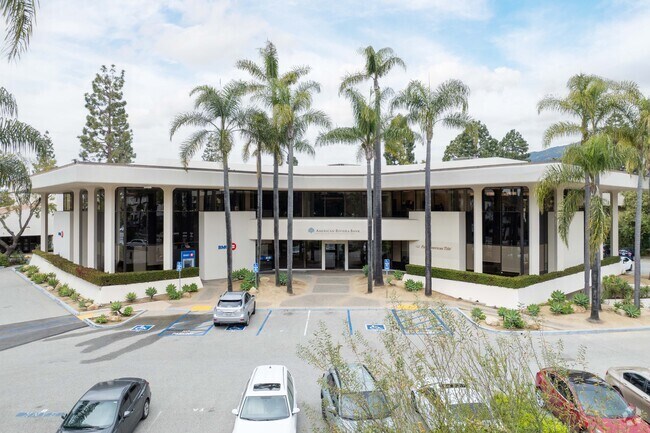
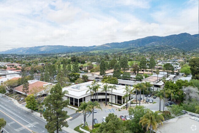
Property Record
3780 State St, Santa Barbara, CA 93105

Property Detail
3780 State St
Santa Maria-Santa Barbara, CA
SB CITY MAP 42 LOT 121
053-300-026
Santa Barbara
Financialbuilding
California
CPSD2
121
AE The base floodplain where base flood elevations are provided. AE Zones are now used on new format FIRMs instead of A1-A30 Zones.
1.44 AC
2024
N Santa Barbara/Goleta
2025
Santa Barbara/Sta Maria/Goleta
000102
NEARBY LISTINGS FOR SALE OR LEASE
DEMOGRAPHICS near 3780 State St
1 mile
3 mile
5 mile
2025 Total Population
14,421
77,160
133,321
2030 Population
14,487
76,864
133,105
Pop Growth 2025-2030
+ 0.46%
(0.38%)
(0.16%)
Average Age
44
43
42
2025 Total Households
6,109
31,082
51,466
HH Growth 2025-2030
+ 0.41%
(0.48%)
(0.17%)
Median Household Inc
$112,524
$110,540
$106,812
Avg Household Size
2.30
2.30
2.40
2025 Avg HH Vehicles
2.00
2.00
2.00
Median Home Value
$1,095,882
$1,111,276
$1,106,505
Median Year Built
1970
1965
1966
Nearby Places
Map Layers
Map Styles
 Street
 Aerial
Layers
 Traffic
 Biking
Places
Listings with unknown addresses are not visible on the map
- Restaurants
- Banks
- Shops
- Fitness
- Groceries
PUBLIC TRANSPORTATION
COMMUTER RAIL
Drive
Walk
Distance
8 min
4.4 mi
Drive
Walk
Distance
11 min
6.4 mi
AIRPORT
Santa Barbara Municipal
Drive
Walk
Distance
Santa Barbara Municipal
24 min
8.7 mi
Freight Ports
The Port of Hueneme
Drive
Walk
Distance
The Port of Hueneme
60 min
43.7 mi
SALE & LEASE HISTORY
LISTING DATE
SALE/LEASE

Jul 27, 2020
For Lease
Feb 24, 2021
For Lease
Nearby Properties
Address
Land Use
TOTAL SIZE
Lot Size
Zoning
Address
Land Use
TOTAL SIZE
Lot Size
Zoning
710 SF
9.92 AC
SP8
Address
Land Use
TOTAL SIZE
Lot Size
Zoning
16.87 AC
E3SD2
Address
Land Use
TOTAL SIZE
Lot Size
Zoning
0.39 AC
C2
Address
Land Use
TOTAL SIZE
Lot Size
Zoning
7.06 AC
R240R
Address
Land Use
TOTAL SIZE
Lot Size
Zoning
Address
Land Use
TOTAL SIZE
Lot Size
Zoning
1.43 AC
Address
Land Use
TOTAL SIZE
Lot Size
Zoning
10.48 AC
C2SD2
Address
Land Use
TOTAL SIZE
Lot Size
Zoning
0.37 AC
C2
Address
Land Use
TOTAL SIZE
Lot Size
Zoning
8.79 AC
C2SD2
Address
Land Use
TOTAL SIZE
Lot Size
Zoning
4.32 AC
CP
Address
Land Use
TOTAL SIZE
Lot Size
Zoning
0.99 AC
Address
Land Use
TOTAL SIZE
Lot Size
Zoning
9.21 AC
R2
Address
Land Use
TOTAL SIZE
Lot Size
Zoning
1.32 AC
Address
Land Use
TOTAL SIZE
Lot Size
Zoning
4.94 AC
CPSD2
Address
Land Use
TOTAL SIZE
Lot Size
Zoning
2.62 AC
C2
Address
Land Use
TOTAL SIZE
Lot Size
Zoning
11.37 AC
E1
Address
Land Use
TOTAL SIZE
Lot Size
Zoning
27,346 SF
8.72 AC
SP7
Address
Land Use
TOTAL SIZE
Lot Size
Zoning
1.35 AC
C2SD2
Address
Land Use
TOTAL SIZE
Lot Size
Zoning
1,525 SF
2.40 AC
SP8
Address
Land Use
TOTAL SIZE
Lot Size
Zoning
0.93 AC
Address
Land Use
TOTAL SIZE
Lot Size
Zoning
5.91 AC
DR20
Address
Land Use
TOTAL SIZE
Lot Size
Zoning
0.30 AC
C2
Address
Land Use
TOTAL SIZE
Lot Size
Zoning
1 AC
C2
Address
Land Use
TOTAL SIZE
Lot Size
Zoning
5.44 AC
R3SD2
Address
Land Use
TOTAL SIZE
Lot Size
Zoning
14.08 AC
E3
Address
Land Use
TOTAL SIZE
Lot Size
Zoning
0.58 AC
C2
Address
Land Use
TOTAL SIZE
Lot Size
Zoning
4.08 AC
C1SD2
Address
Land Use
TOTAL SIZE
Lot Size
Zoning
5.29 AC
C2SD2
Address
Land Use
TOTAL SIZE
Lot Size
Zoning
1.11 AC
Address
Land Use
TOTAL SIZE
Lot Size
Zoning
2.30 AC
R3
The World's #1 Commercial Real Estate Marketplace
Connect with us
© 2026 CoStar Group
The information above has been obtained from sources believed reliable. While we do not doubt its accuracy we have not verified it and make no guarantee, warranty or representation about it. It is your responsibility to independently confirm its accuracy and completeness. Any projections, opinions, assumptions, or estimates used are for example only and do not represent the current or future performance of the property. The value of this transaction to you depends on tax and other factors which should be evaluated by your tax, financial, and legal advisors. You and your advisors should conduct a careful, independent investigation of the property to determine to your satisfaction the suitability of the property for your needs.