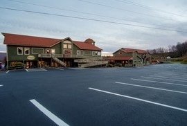
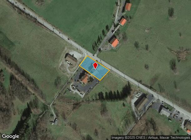
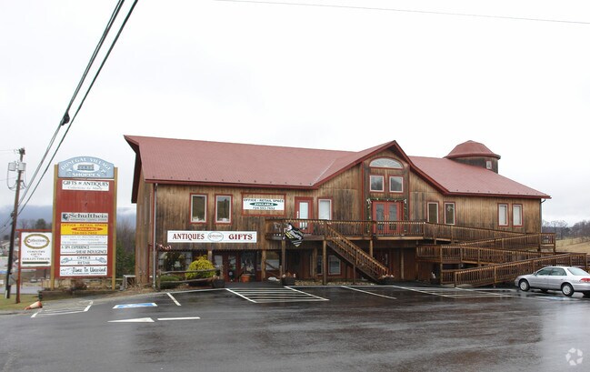
Property Record
3782 State Route 31, Donegal, PA 15628

NEARBY LISTINGS FOR SALE OR LEASE
-
-
View all Donegal listings for lease on LoopNet.com
Property Detail
3782 State Route 31
Pittsburgh, PA
Walnut Hill Subdivision
46-16-00-0-247
LOT A COM BLDG WALNUT HILL SUB 254.66 X 166.66 X IR
Commercialofficeresidentialmixeduse
Westmoreland
X
Pennsylvania
42111C0180D
a
2025
0.97 AC
2025
Westmoreland County
808600
Pittsburgh
DEMOGRAPHICS near 3782 State Route 31
1 Mile
3 Mile
5 Mile
2024 Total Population
421
2,217
5,040
2029 Population
404
2,139
4,892
Pop Growth 2024-2029
(4.04%)
(3.52%)
(2.94%)
Average Age
47
47
46
2024 Total Households
192
970
2,160
HH Growth 2024-2029
(4.17%)
(3.71%)
(3.10%)
Median Household Inc
$48,928
$56,515
$57,543
Avg Household Size
2.20
2.30
2.30
2024 Avg HH Vehicles
2.00
2.00
2.00
Median Home Value
$151,851
$182,464
$177,316
Median Year Built
1974
1971
1971
Nearby Places
Map Layers
Map Styles
 Street
 Aerial
- Restaurants
- Banks
- Shops
- Fitness
- Groceries
PUBLIC TRANSPORTATION
AIRPORT
Arnold Palmer Regional
DRIVE
WALK
Distance
Arnold Palmer Regional
33 min
17.8 mi
SALE & LEASE HISTORY
LISTING DATE
SALE/LEASE

Mar 08, 2018
For Lease
Jun 30, 2017
For Sale
Jun 30, 2017
For Sale
Jul 26, 2017
For Sale
Jul 26, 2017
For Sale
Jul 03, 2017
For Sale
Feb 16, 2018
For Sale
Nearby Properties
Address
Land Use
TOTAL SIZE
Lot Size
Zoning
Address
Land Use
TOTAL SIZE
Lot Size
Zoning
3,600 SF
71.14 AC
Address
Land Use
TOTAL SIZE
Lot Size
Zoning
43,734 SF
5.09 AC
Address
Land Use
TOTAL SIZE
Lot Size
Zoning
Address
Land Use
TOTAL SIZE
Lot Size
Zoning
202,891 SF
29.40 AC
Address
Land Use
TOTAL SIZE
Lot Size
Zoning
9,120 SF
162.40 AC
Address
Land Use
TOTAL SIZE
Lot Size
Zoning
53,888 SF
6.63 AC
Address
Land Use
TOTAL SIZE
Lot Size
Zoning
132.82 AC
Address
Land Use
TOTAL SIZE
Lot Size
Zoning
11,118 SF
182.81 AC
Address
Land Use
TOTAL SIZE
Lot Size
Zoning
21,885 SF
3.42 AC
Address
Land Use
TOTAL SIZE
Lot Size
Zoning
Address
Land Use
TOTAL SIZE
Lot Size
Zoning
11,720 SF
8.20 AC
Address
Land Use
TOTAL SIZE
Lot Size
Zoning
8,360 SF
9.01 AC
Address
Land Use
TOTAL SIZE
Lot Size
Zoning
3,055 SF
181.70 AC
Address
Land Use
TOTAL SIZE
Lot Size
Zoning
0.92 AC
Address
Land Use
TOTAL SIZE
Lot Size
Zoning
1,200 SF
31.47 AC
Address
Land Use
TOTAL SIZE
Lot Size
Zoning
1,220 SF
4.79 AC
Address
Land Use
TOTAL SIZE
Lot Size
Zoning
Address
Land Use
TOTAL SIZE
Lot Size
Zoning
68.98 AC
Address
Land Use
TOTAL SIZE
Lot Size
Zoning
11,346 SF
49.51 AC
Address
Land Use
TOTAL SIZE
Lot Size
Zoning
1,680 SF
107.09 AC
Address
Land Use
TOTAL SIZE
Lot Size
Zoning
3,936 SF
26.98 AC
Address
Land Use
TOTAL SIZE
Lot Size
Zoning
4,976 SF
0.49 AC
Address
Land Use
TOTAL SIZE
Lot Size
Zoning
5,184 SF
1.33 AC
Address
Land Use
TOTAL SIZE
Lot Size
Zoning
Address
Land Use
TOTAL SIZE
Lot Size
Zoning
9,200 SF
16.60 AC
Address
Land Use
TOTAL SIZE
Lot Size
Zoning
2,816 SF
1.27 AC
Address
Land Use
TOTAL SIZE
Lot Size
Zoning
3,696 SF
58.50 AC
Address
Land Use
TOTAL SIZE
Lot Size
Zoning
5.60 AC
Address
Land Use
TOTAL SIZE
Lot Size
Zoning
The World's #1 Commercial Real Estate Marketplace
Connect with us
© 2026 CoStar Group
The information above has been obtained from sources believed reliable. While we do not doubt its accuracy we have not verified it and make no guarantee, warranty or representation about it. It is your responsibility to independently confirm its accuracy and completeness. Any projections, opinions, assumptions, or estimates used are for example only and do not represent the current or future performance of the property. The value of this transaction to you depends on tax and other factors which should be evaluated by your tax, financial, and legal advisors. You and your advisors should conduct a careful, independent investigation of the property to determine to your satisfaction the suitability of the property for your needs.