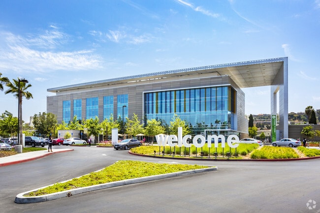
Property Record
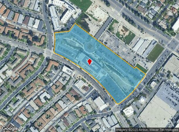
3782 W Martin Luther King Jr Blvd, Los Angeles, CA 90008

NEARBY LISTINGS FOR SALE OR LEASE
Property Detail
3782 W Martin Luther King Jr Blvd
5032-005-008
TR=16050 FOR DESC SEE ASSESSORS MAPS LOTS 28 THRU 48 AND POR LOTS 51 AND 52
Officebuilding
Los Angeles
X
California
06037C1614G
29
2024
8.69 AC
2025
Inglewood/South LA
236101
Los Angeles
102,877 SF
Los Angeles-Long Beach-Glendale, CA
DEMOGRAPHICS near 3782 W Martin Luther King Jr Blvd
1 Mile
3 Mile
5 Mile
2024 Total Population
38,609
343,239
1,130,663
2029 Population
37,873
332,561
1,097,727
Pop Growth 2024-2029
(1.91%)
(3.11%)
(2.91%)
Average Age
42
40
38
2024 Total Households
16,266
120,219
417,321
HH Growth 2024-2029
(2.21%)
(3.29%)
(2.89%)
Median Household Inc
$47,567
$60,068
$63,442
Avg Household Size
2.30
2.70
2.60
2024 Avg HH Vehicles
1.00
2.00
1.00
Median Home Value
$842,595
$817,127
$888,770
Median Year Built
1954
1949
1957
Nearby Places
Map Layers
Map Styles
 Street
 Aerial
- Restaurants
- Banks
- Shops
- Fitness
- Groceries
PUBLIC TRANSPORTATION
COMMUTER RAIL
DRIVE
WALK
Distance
16 min
8.6 mi
Union Station (91 Line - Southern California Regional Rail Authority (Metrolink), Antelope Valley Line - Southern California Regional Rail Authority (Metrolink), Orange County Line - Southern California Regional Rail Authority (Metrolink), Riverside Line - Southern California Regional Rail Authority (Metrolink), San Bernardino Line - Southern California Regional Rail Authority (Metrolink), Ventura County Line - Southern California Regional Rail Authority (Metrolink))
DRIVE
WALK
Distance
Union Station (91 Line - Southern California Regional Rail Authority (Metrolink), Antelope Valley Line - Southern California Regional Rail Authority (Metrolink), Orange County Line - Southern California Regional Rail Authority (Metrolink), Riverside Line - Southern California Regional Rail Authority (Metrolink), San Bernardino Line - Southern California Regional Rail Authority (Metrolink), Ventura County Line - Southern California Regional Rail Authority (Metrolink))
18 min
8.8 mi
AIRPORT
Los Angeles International
DRIVE
WALK
Distance
Los Angeles International
16 min
7.6 mi
Bob Hope
DRIVE
WALK
Distance
Bob Hope
33 min
15.4 mi
Long Beach (Daugherty Field)
DRIVE
WALK
Distance
Long Beach (Daugherty Field)
33 min
24.1 mi
Freight Ports
Port of Los Angeles
DRIVE
WALK
Distance
Port of Los Angeles
41 min
26.1 mi
Nearby Properties
Address
Land Use
TOTAL SIZE
Lot Size
Zoning
Address
Land Use
TOTAL SIZE
Lot Size
Zoning
597,713 SF
11.18 AC
CCS1YY
Address
Land Use
TOTAL SIZE
Lot Size
Zoning
871,235 SF
14.56 AC
LAC2
Address
Land Use
TOTAL SIZE
Lot Size
Zoning
368,411 SF
10.91 AC
C2-2D-CPIO
Address
Land Use
TOTAL SIZE
Lot Size
Zoning
786,423 SF
11.74 AC
LAC2
Address
Land Use
TOTAL SIZE
Lot Size
Zoning
78,793 SF
3.53 AC
LAMR1
Address
Land Use
TOTAL SIZE
Lot Size
Zoning
377,946 SF
5.03 AC
LAUSC-1A
Address
Land Use
TOTAL SIZE
Lot Size
Zoning
106,000 SF
4.26 AC
LAMR 1
Address
Land Use
TOTAL SIZE
Lot Size
Zoning
237,673 SF
3.73 AC
M1-2D-CPIO
Address
Land Use
TOTAL SIZE
Lot Size
Zoning
128,347 SF
2.83 AC
LACM
Address
Land Use
TOTAL SIZE
Lot Size
Zoning
73,918 SF
3.86 AC
LAM1
Address
Land Use
TOTAL SIZE
Lot Size
Zoning
175,479 SF
1.63 AC
CCC3VV
Address
Land Use
TOTAL SIZE
Lot Size
Zoning
31,358 SF
5.43 AC
LAMR
Address
Land Use
TOTAL SIZE
Lot Size
Zoning
343,879 SF
4.26 AC
LAC2
Address
Land Use
TOTAL SIZE
Lot Size
Zoning
214,155 SF
3.33 AC
CCM1
Address
Land Use
TOTAL SIZE
Lot Size
Zoning
203,272 SF
14.53 AC
LAC2
Address
Land Use
TOTAL SIZE
Lot Size
Zoning
148,152 SF
3.77 AC
CCM1*
Address
Land Use
TOTAL SIZE
Lot Size
Zoning
66,581 SF
0.60 AC
CCC3YY
Address
Land Use
TOTAL SIZE
Lot Size
Zoning
377,831 SF
8.17 AC
LCC4*
Address
Land Use
TOTAL SIZE
Lot Size
Zoning
376,135 SF
8.02 AC
LCC4*
Address
Land Use
TOTAL SIZE
Lot Size
Zoning
72,641 SF
1.65 AC
CCM1*
Address
Land Use
TOTAL SIZE
Lot Size
Zoning
102,789 SF
0.86 AC
INR3*
Address
Land Use
TOTAL SIZE
Lot Size
Zoning
57,488 SF
4.30 AC
LAPF
Address
Land Use
TOTAL SIZE
Lot Size
Zoning
220,083 SF
4.95 AC
LAR3
Address
Land Use
TOTAL SIZE
Lot Size
Zoning
185,343 SF
1.27 AC
LAC1.5
Address
Land Use
TOTAL SIZE
Lot Size
Zoning
76,895 SF
1.49 AC
CMM1*
Address
Land Use
TOTAL SIZE
Lot Size
Zoning
376,236 SF
1.19 AC
CCR2YY
Address
Land Use
TOTAL SIZE
Lot Size
Zoning
165,898 SF
1.27 AC
CCC3*
Address
Land Use
TOTAL SIZE
Lot Size
Zoning
134,044 SF
1.90 AC
LAC2
Address
Land Use
TOTAL SIZE
Lot Size
Zoning
286,496 SF
9.60 AC
LAC2
The World's #1 Commercial Real Estate Marketplace
Connect with us
© 2025 CoStar Group
The information above has been obtained from sources believed reliable. While we do not doubt its accuracy we have not verified it and make no guarantee, warranty or representation about it. It is your responsibility to independently confirm its accuracy and completeness. Any projections, opinions, assumptions, or estimates used are for example only and do not represent the current or future performance of the property. The value of this transaction to you depends on tax and other factors which should be evaluated by your tax, financial, and legal advisors. You and your advisors should conduct a careful, independent investigation of the property to determine to your satisfaction the suitability of the property for your needs.