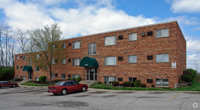
Property Record
3782 Westmont Dr, Cincinnati, OH 45205
NEARBY LISTINGS FOR SALE OR LEASE
Property Detail
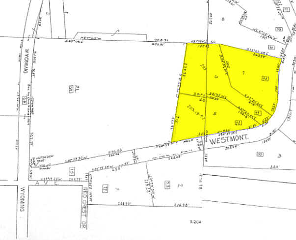
3782 Westmont Dr
Cincinnati, OH-KY-IN
Westside Apartment Sub
205-0019-0072
WESTMONT DR 249.07 X 263.59 IRR LOT 7 WESTSIDE APARTMENT SUB BLK A PT 2
Apartment
Hamilton
X
Ohio
21037C0025E
7
2024
1.16 AC
2024
South Fairmount
009200
Cincinnati/Dayton
10,500 SF
DEMOGRAPHICS near 3782 Westmont Dr
1 Mile
3 Mile
5 Mile
2024 Total Population
16,695
133,158
308,445
2029 Population
16,709
133,645
310,568
Pop Growth 2024-2029
+ 0.08%
+ 0.37%
+ 0.69%
Average Age
34
36
37
2024 Total Households
6,091
55,790
133,634
HH Growth 2024-2029
+ 0.05%
+ 0.37%
+ 0.78%
Median Household Inc
$31,708
$37,777
$48,267
Avg Household Size
2.50
2.20
2.10
2024 Avg HH Vehicles
1.00
1.00
1.00
Median Home Value
$73,827
$142,100
$175,920
Median Year Built
1949
1957
1957
Nearby Places
Map Layers
Map Styles
 Street
 Aerial
- Restaurants
- Banks
- Shops
- Fitness
- Groceries
PUBLIC TRANSPORTATION
COMMUTER RAIL
Cincinnati Union Terminal (Cardinal - Amtrak)
DRIVE
WALK
Distance
Cincinnati Union Terminal (Cardinal - Amtrak)
10 min
4.0 mi
AIRPORT
Cincinnati/Northern Kentucky International
DRIVE
WALK
Distance
Cincinnati/Northern Kentucky International
34 min
18.1 mi
Freight Ports
Port of Toledo
DRIVE
WALK
Distance
Port of Toledo
246 min
207.1 mi
SALE & LEASE HISTORY
LISTING DATE
SALE/LEASE

Sep 21, 2017
For Sale
Nearby Properties
Address
Land Use
TOTAL SIZE
Lot Size
Zoning
Address
Land Use
TOTAL SIZE
Lot Size
Zoning
11.82 AC
Address
Land Use
TOTAL SIZE
Lot Size
Zoning
22.45 AC
Address
Land Use
TOTAL SIZE
Lot Size
Zoning
3.09 AC
Address
Land Use
TOTAL SIZE
Lot Size
Zoning
9.38 AC
PR
Address
Land Use
TOTAL SIZE
Lot Size
Zoning
29.60 AC
IR
Address
Land Use
TOTAL SIZE
Lot Size
Zoning
3.27 AC
CCA
Address
Land Use
TOTAL SIZE
Lot Size
Zoning
10,778 SF
0.09 AC
CCM
Address
Land Use
TOTAL SIZE
Lot Size
Zoning
17,857 SF
26.60 AC
CGA
Address
Land Use
TOTAL SIZE
Lot Size
Zoning
Address
Land Use
TOTAL SIZE
Lot Size
Zoning
23.05 AC
Address
Land Use
TOTAL SIZE
Lot Size
Zoning
8.18 AC
SF4
Address
Land Use
TOTAL SIZE
Lot Size
Zoning
2 AC
RM12
Address
Land Use
TOTAL SIZE
Lot Size
Zoning
77,628 SF
2.18 AC
Address
Land Use
TOTAL SIZE
Lot Size
Zoning
13.44 AC
Address
Land Use
TOTAL SIZE
Lot Size
Zoning
50,350 SF
15.41 AC
MG
Address
Land Use
TOTAL SIZE
Lot Size
Zoning
1.57 AC
Address
Land Use
TOTAL SIZE
Lot Size
Zoning
1.47 AC
Address
Land Use
TOTAL SIZE
Lot Size
Zoning
2.16 AC
MG
Address
Land Use
TOTAL SIZE
Lot Size
Zoning
414,133 SF
4.07 AC
RMX
Address
Land Use
TOTAL SIZE
Lot Size
Zoning
20,199 SF
9.82 AC
SF10
Address
Land Use
TOTAL SIZE
Lot Size
Zoning
112,560 SF
7.49 AC
IR
Address
Land Use
TOTAL SIZE
Lot Size
Zoning
1.73 AC
RM12
Address
Land Use
TOTAL SIZE
Lot Size
Zoning
Address
Land Use
TOTAL SIZE
Lot Size
Zoning
6,537 SF
12.55 AC
Address
Land Use
TOTAL SIZE
Lot Size
Zoning
1,873 SF
12.20 AC
Address
Land Use
TOTAL SIZE
Lot Size
Zoning
22.17 AC
Address
Land Use
TOTAL SIZE
Lot Size
Zoning
Address
Land Use
TOTAL SIZE
Lot Size
Zoning
125,405 SF
16.69 AC
SF6
Address
Land Use
TOTAL SIZE
Lot Size
Zoning
6.15 AC
SF2
Address
Land Use
TOTAL SIZE
Lot Size
Zoning
1.69 AC
The World's #1 Commercial Real Estate Marketplace
Connect with us
© 2025 CoStar Group
The information above has been obtained from sources believed reliable. While we do not doubt its accuracy we have not verified it and make no guarantee, warranty or representation about it. It is your responsibility to independently confirm its accuracy and completeness. Any projections, opinions, assumptions, or estimates used are for example only and do not represent the current or future performance of the property. The value of this transaction to you depends on tax and other factors which should be evaluated by your tax, financial, and legal advisors. You and your advisors should conduct a careful, independent investigation of the property to determine to your satisfaction the suitability of the property for your needs.