Property Record
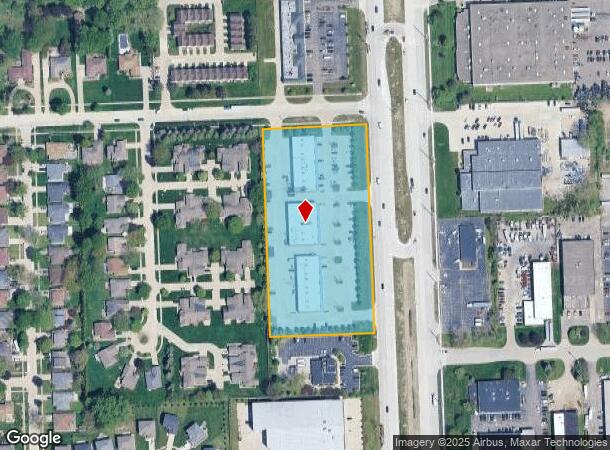
37821 Mound Rd, Sterling Heights, MI 48310
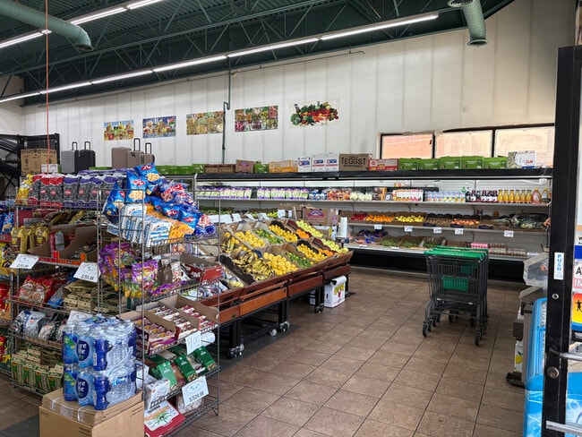
This Property Is For Sale
Current Lease Availabilities
NEARBY LISTINGS FOR SALE OR LEASE
Property Detail
37821 Mound Rd
10-10-20-426-020
T2N, R12E SEC 20 DESC AS, BEG AT INTER OF S LINE FOX HILL DR (86' WD) & W LINE MOUND RD (204.00' WD) A DIST N89*49'30"W
Commercialnec
Macomb
X
Michigan
26099C0308G
4.12 AC
2025
Macomb West
2025
Detroit
231400
Detroit-Warren-Dearborn, MI
10,400 SF
DEMOGRAPHICS near 37821 Mound Rd
1 Mile
3 Mile
5 Mile
2024 Total Population
9,054
100,609
265,441
2029 Population
8,851
99,271
262,267
Pop Growth 2024-2029
(2.24%)
(1.33%)
(1.20%)
Average Age
41
42
42
2024 Total Households
2,936
36,866
104,997
HH Growth 2024-2029
(2.28%)
(1.36%)
(1.20%)
Median Household Inc
$68,900
$71,623
$73,252
Avg Household Size
2.90
2.70
2.50
2024 Avg HH Vehicles
2.00
2.00
2.00
Median Home Value
$245,195
$242,079
$233,257
Median Year Built
1977
1974
1974
Nearby Places
Map Layers
Map Styles
 Street
 Aerial
- Restaurants
- Banks
- Shops
- Fitness
- Groceries
PUBLIC TRANSPORTATION
COMMUTER RAIL
DRIVE
WALK
Distance
18 min
9.3 mi
AIRPORT
Windsor International
DRIVE
WALK
Distance
Windsor International
52 min
30.3 mi
Detroit Metro Wayne County
DRIVE
WALK
Distance
Detroit Metro Wayne County
56 min
39.8 mi
Nearby Properties
Address
Land Use
TOTAL SIZE
Lot Size
Zoning
Address
Land Use
TOTAL SIZE
Lot Size
Zoning
920,611 SF
M-2
Address
Land Use
TOTAL SIZE
Lot Size
Zoning
1,024,233 SF
287.20 AC
M-2
Address
Land Use
TOTAL SIZE
Lot Size
Zoning
983,373 SF
60.16 AC
M-2
Address
Land Use
TOTAL SIZE
Lot Size
Zoning
2,726,159 SF
199.39 AC
M-2
Address
Land Use
TOTAL SIZE
Lot Size
Zoning
40.32 AC
RM-2
Address
Land Use
TOTAL SIZE
Lot Size
Zoning
146.36 AC
MHP
Address
Land Use
TOTAL SIZE
Lot Size
Zoning
569,813 SF
62.54 AC
M-2
Address
Land Use
TOTAL SIZE
Lot Size
Zoning
2,727,131 SF
155.26 AC
M-2
Address
Land Use
TOTAL SIZE
Lot Size
Zoning
92.30 AC
MHP
Address
Land Use
TOTAL SIZE
Lot Size
Zoning
2,058,062 SF
141.65 AC
M-2
Address
Land Use
TOTAL SIZE
Lot Size
Zoning
226,380 SF
46.45 AC
M-1
Address
Land Use
TOTAL SIZE
Lot Size
Zoning
283,249 SF
M-2
Address
Land Use
TOTAL SIZE
Lot Size
Zoning
229,624 SF
13.55 AC
M-2
Address
Land Use
TOTAL SIZE
Lot Size
Zoning
645 SF
23.16 AC
RM-2
Address
Land Use
TOTAL SIZE
Lot Size
Zoning
2,984,492 SF
M-2
Address
Land Use
TOTAL SIZE
Lot Size
Zoning
423,027 SF
46.73 AC
M-1
Address
Land Use
TOTAL SIZE
Lot Size
Zoning
25.18 AC
RM-2
Address
Land Use
TOTAL SIZE
Lot Size
Zoning
203,282 SF
17.13 AC
C-2
Address
Land Use
TOTAL SIZE
Lot Size
Zoning
201,873 SF
M-1
Address
Land Use
TOTAL SIZE
Lot Size
Zoning
559,929 SF
41.57 AC
M-1
Address
Land Use
TOTAL SIZE
Lot Size
Zoning
135,274 SF
20.55 AC
RM-2
Address
Land Use
TOTAL SIZE
Lot Size
Zoning
139,846 SF
16 AC
RM-2
Address
Land Use
TOTAL SIZE
Lot Size
Zoning
210,000 SF
M-1
Address
Land Use
TOTAL SIZE
Lot Size
Zoning
159,750 SF
16.76 AC
M-1
Address
Land Use
TOTAL SIZE
Lot Size
Zoning
205,993 SF
19.90 AC
MZ
Address
Land Use
TOTAL SIZE
Lot Size
Zoning
16.11 AC
RM-2
Address
Land Use
TOTAL SIZE
Lot Size
Zoning
204,086 SF
18.72 AC
RM1
Address
Land Use
TOTAL SIZE
Lot Size
Zoning
219,437 SF
18.80 AC
PCD
Address
Land Use
TOTAL SIZE
Lot Size
Zoning
554,374 SF
22.15 AC
M-2
Address
Land Use
TOTAL SIZE
Lot Size
Zoning
200,000 SF
17.66 AC
M-2
The World's #1 Commercial Real Estate Marketplace
Connect with us
© 2026 CoStar Group
The information above has been obtained from sources believed reliable. While we do not doubt its accuracy we have not verified it and make no guarantee, warranty or representation about it. It is your responsibility to independently confirm its accuracy and completeness. Any projections, opinions, assumptions, or estimates used are for example only and do not represent the current or future performance of the property. The value of this transaction to you depends on tax and other factors which should be evaluated by your tax, financial, and legal advisors. You and your advisors should conduct a careful, independent investigation of the property to determine to your satisfaction the suitability of the property for your needs.