Property Record
3785 Codet Rd, Columbus, OH 43219
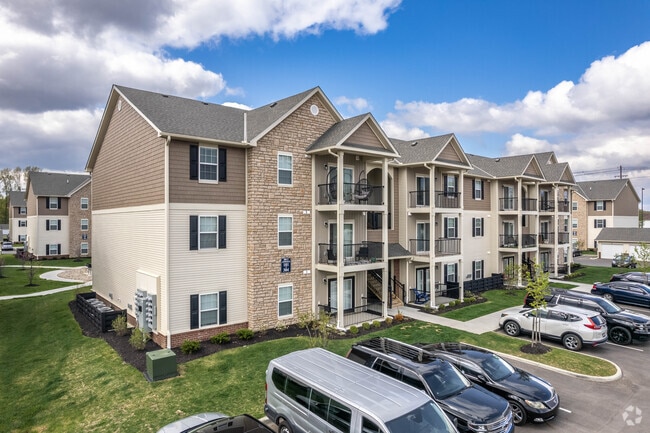
Property Detail
3785 Codet Rd
010-255287
2530 STELZER RD R17 T1 1/4T1 0.361 ACRE
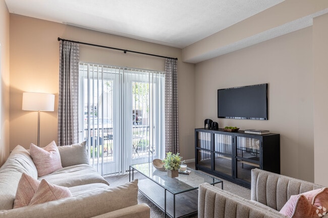
Apartment
FRANKLIN
B and X Area of moderate flood hazard, usually the area between the limits of the 100-year and 500-year floods.
Ohio
2024
26.82 AC
2025
Somerset
007550
Columbus
150,424 SF
Columbus, OH
NEARBY LISTINGS FOR SALE OR LEASE
DEMOGRAPHICS near 3785 Codet Rd
1 mile
3 mile
5 mile
2025 Total Population
14,898
76,977
274,562
2030 Population
15,501
79,335
283,120
Pop Growth 2025-2030
+ 4.05%
+ 3.06%
+ 3.12%
Average Age
35
37
37
2025 Total Households
5,695
29,543
109,144
HH Growth 2025-2030
+ 3.83%
+ 3.15%
+ 3.23%
Median Household Inc
$69,799
$65,012
$60,217
Avg Household Size
2.60
2.50
2.40
2025 Avg HH Vehicles
2.00
2.00
2.00
Median Home Value
$267,250
$266,795
$262,333
Median Year Built
1993
1981
1974
Nearby Places
Map Layers
Map Styles
 Street
 Aerial
Layers
 Traffic
 Biking
Places
Listings with unknown addresses are not visible on the map
- Restaurants
- Banks
- Shops
- Fitness
- Groceries
PUBLIC TRANSPORTATION
AIRPORT
John Glenn Columbus International
Drive
Walk
Distance
John Glenn Columbus International
7 min
3.2 mi
Rickenbacker International
Drive
Walk
Distance
Rickenbacker International
26 min
16.3 mi
Freight Ports
Port of Toledo
Drive
Walk
Distance
Port of Toledo
183 min
144.4 mi
Nearby Properties
Address
Land Use
TOTAL SIZE
Lot Size
Zoning
Address
Land Use
TOTAL SIZE
Lot Size
Zoning
1,256,678 SF
1,292.62 AC
Address
Land Use
TOTAL SIZE
Lot Size
Zoning
2,299,970 SF
60.76 AC
Address
Land Use
TOTAL SIZE
Lot Size
Zoning
Address
Land Use
TOTAL SIZE
Lot Size
Zoning
1,935,173 SF
202.04 AC
Address
Land Use
TOTAL SIZE
Lot Size
Zoning
529,035 SF
37.56 AC
Address
Land Use
TOTAL SIZE
Lot Size
Zoning
449,494 SF
9.75 AC
Address
Land Use
TOTAL SIZE
Lot Size
Zoning
284,481 SF
94.09 AC
Address
Land Use
TOTAL SIZE
Lot Size
Zoning
570,003 SF
29.71 AC
Address
Land Use
TOTAL SIZE
Lot Size
Zoning
770,975 SF
64.63 AC
Address
Land Use
TOTAL SIZE
Lot Size
Zoning
316,548 SF
145.20 AC
Address
Land Use
TOTAL SIZE
Lot Size
Zoning
516,485 SF
50.03 AC
Address
Land Use
TOTAL SIZE
Lot Size
Zoning
25,298 SF
33.25 AC
Address
Land Use
TOTAL SIZE
Lot Size
Zoning
329,049 SF
38.53 AC
Address
Land Use
TOTAL SIZE
Lot Size
Zoning
242,064 SF
18.02 AC
Address
Land Use
TOTAL SIZE
Lot Size
Zoning
240,432 SF
16.59 AC
Address
Land Use
TOTAL SIZE
Lot Size
Zoning
537,537 SF
77.62 AC
Address
Land Use
TOTAL SIZE
Lot Size
Zoning
214,424 SF
18.57 AC
Address
Land Use
TOTAL SIZE
Lot Size
Zoning
299,890 SF
74.80 AC
Address
Land Use
TOTAL SIZE
Lot Size
Zoning
88,068 SF
15.43 AC
Address
Land Use
TOTAL SIZE
Lot Size
Zoning
668,209 SF
61.10 AC
Address
Land Use
TOTAL SIZE
Lot Size
Zoning
274,272 SF
6.45 AC
Address
Land Use
TOTAL SIZE
Lot Size
Zoning
165,944 SF
14.21 AC
Address
Land Use
TOTAL SIZE
Lot Size
Zoning
332,616 SF
26.90 AC
Address
Land Use
TOTAL SIZE
Lot Size
Zoning
209,542 SF
27.50 AC
Address
Land Use
TOTAL SIZE
Lot Size
Zoning
331,458 SF
15.37 AC
Address
Land Use
TOTAL SIZE
Lot Size
Zoning
42,596 SF
37.05 AC
Address
Land Use
TOTAL SIZE
Lot Size
Zoning
67,166 SF
11.03 AC
Address
Land Use
TOTAL SIZE
Lot Size
Zoning
500,376 SF
3 AC
Address
Land Use
TOTAL SIZE
Lot Size
Zoning
202,956 SF
13.40 AC
The World's #1 Commercial Real Estate Marketplace
Connect with us
© 2026 CoStar Group
The information above has been obtained from sources believed reliable. While we do not doubt its accuracy we have not verified it and make no guarantee, warranty or representation about it. It is your responsibility to independently confirm its accuracy and completeness. Any projections, opinions, assumptions, or estimates used are for example only and do not represent the current or future performance of the property. The value of this transaction to you depends on tax and other factors which should be evaluated by your tax, financial, and legal advisors. You and your advisors should conduct a careful, independent investigation of the property to determine to your satisfaction the suitability of the property for your needs.