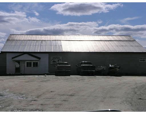
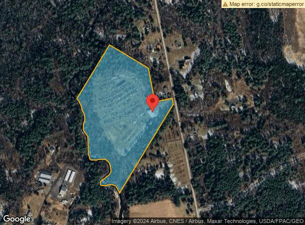
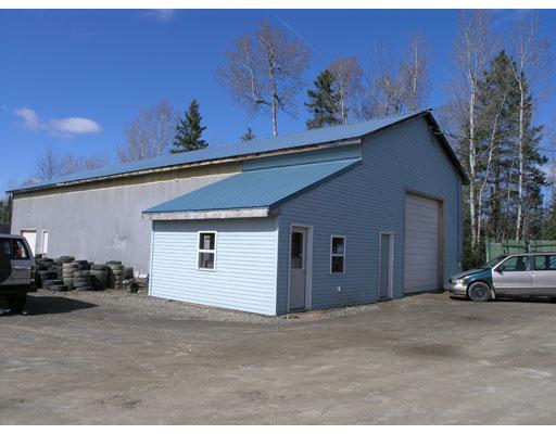
Property Record
379 Brewer Lake Rd, Orrington, ME 04474
NEARBY LISTINGS FOR SALE OR LEASE
Property Detail
379 Brewer Lake Rd
ORRI-000009-000000-000087-A000000
Penobscot
Commercialbuilding
Maine
AE
87-a
23019C2307D
21 AC
2024
Other Market Areas
2024
Bangor, ME
003000
DEMOGRAPHICS near 379 Brewer Lake Rd
1 Mile
3 Mile
5 Mile
2024 Total Population
560
8,425
37,166
2029 Population
576
8,606
38,029
Pop Growth 2024-2029
+ 2.86%
+ 2.15%
+ 2.32%
Average Age
47
45
43
2024 Total Households
241
3,598
17,039
HH Growth 2024-2029
+ 2.49%
+ 2.17%
+ 2.45%
Median Household Inc
$71,738
$72,874
$55,957
Avg Household Size
2.30
2.20
2.10
2024 Avg HH Vehicles
2.00
2.00
2.00
Median Home Value
$220,130
$226,780
$218,208
Median Year Built
1977
1972
1958
Nearby Places
Map Layers
Map Styles
 Street
 Aerial
- Restaurants
- Banks
- Shops
- Fitness
- Groceries
PUBLIC TRANSPORTATION
AIRPORT
Bangor International
DRIVE
WALK
Distance
Bangor International
17 min
7.8 mi
Freight Ports
Searsport, ME
DRIVE
WALK
Distance
Searsport, ME
48 min
29.9 mi
Nearby Properties
Address
Land Use
TOTAL SIZE
Lot Size
Zoning
Address
Land Use
TOTAL SIZE
Lot Size
Zoning
Address
Land Use
TOTAL SIZE
Lot Size
Zoning
6.37 AC
UID
Address
Land Use
TOTAL SIZE
Lot Size
Zoning
12,950 SF
23.39 AC
31 - I
Address
Land Use
TOTAL SIZE
Lot Size
Zoning
168,615 SF
19.44 AC
MDR-1
Address
Land Use
TOTAL SIZE
Lot Size
Zoning
184,000 SF
16.43 AC
31 - I
Address
Land Use
TOTAL SIZE
Lot Size
Zoning
68,708 SF
7.85 AC
PB
Address
Land Use
TOTAL SIZE
Lot Size
Zoning
34.50 AC
Address
Land Use
TOTAL SIZE
Lot Size
Zoning
Address
Land Use
TOTAL SIZE
Lot Size
Zoning
161,540 SF
23.68 AC
GB
Address
Land Use
TOTAL SIZE
Lot Size
Zoning
139,863 SF
20.68 AC
GB
Address
Land Use
TOTAL SIZE
Lot Size
Zoning
Address
Land Use
TOTAL SIZE
Lot Size
Zoning
28.15 AC
GB
Address
Land Use
TOTAL SIZE
Lot Size
Zoning
96,178 SF
10.63 AC
GB
Address
Land Use
TOTAL SIZE
Lot Size
Zoning
16.63 AC
GB
Address
Land Use
TOTAL SIZE
Lot Size
Zoning
39.32 AC
CB
Address
Land Use
TOTAL SIZE
Lot Size
Zoning
13.98 AC
GB
Address
Land Use
TOTAL SIZE
Lot Size
Zoning
38,280 SF
13 AC
31 - I
Address
Land Use
TOTAL SIZE
Lot Size
Zoning
2.50 AC
IND
Address
Land Use
TOTAL SIZE
Lot Size
Zoning
37,800 SF
10.96 AC
IND
Address
Land Use
TOTAL SIZE
Lot Size
Zoning
25,400 SF
1 AC
PB
Address
Land Use
TOTAL SIZE
Lot Size
Zoning
23,347 SF
1 AC
PB
Address
Land Use
TOTAL SIZE
Lot Size
Zoning
28,685 SF
11.15 AC
PB
Address
Land Use
TOTAL SIZE
Lot Size
Zoning
28,244 SF
11.15 AC
PB
Address
Land Use
TOTAL SIZE
Lot Size
Zoning
12,432 SF
5.03 AC
GB
Address
Land Use
TOTAL SIZE
Lot Size
Zoning
61,048 SF
9.09 AC
IND
Address
Land Use
TOTAL SIZE
Lot Size
Zoning
Address
Land Use
TOTAL SIZE
Lot Size
Zoning
32,700 SF
6.07 AC
GB
Address
Land Use
TOTAL SIZE
Lot Size
Zoning
27,876 SF
HDR-2
Address
Land Use
TOTAL SIZE
Lot Size
Zoning
5.25 AC
PB
Address
Land Use
TOTAL SIZE
Lot Size
Zoning
124,400 SF
5.50 AC
IND
The World's #1 Commercial Real Estate Marketplace
Connect with us
© 2026 CoStar Group
The information above has been obtained from sources believed reliable. While we do not doubt its accuracy we have not verified it and make no guarantee, warranty or representation about it. It is your responsibility to independently confirm its accuracy and completeness. Any projections, opinions, assumptions, or estimates used are for example only and do not represent the current or future performance of the property. The value of this transaction to you depends on tax and other factors which should be evaluated by your tax, financial, and legal advisors. You and your advisors should conduct a careful, independent investigation of the property to determine to your satisfaction the suitability of the property for your needs.