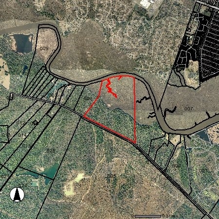
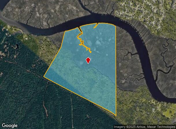
Property Record
Ashley River Rd, Charleston, SC 29414
NEARBY LISTINGS FOR SALE OR LEASE
Property Detail
Ashley River Rd
Charleston-North Charleston, SC
Unmined
361-00-00-005
MAPPLATB L21 MAPPLATP 0332
Residentialacreage
Charleston
AE
South Carolina
45019C0288K
204.26 AC
2025
West Ashley
2024
Charleston/N Charleston
005602
DEMOGRAPHICS near Ashley River Rd
1 Mile
3 Mile
5 Mile
2024 Total Population
1,051
30,903
88,137
2029 Population
1,122
33,149
94,189
Pop Growth 2024-2029
+ 6.76%
+ 7.27%
+ 6.87%
Average Age
41
37
37
2024 Total Households
451
12,092
34,543
HH Growth 2024-2029
+ 6.65%
+ 7.23%
+ 6.71%
Median Household Inc
$83,500
$60,656
$64,818
Avg Household Size
2.30
2.50
2.50
2024 Avg HH Vehicles
2.00
2.00
2.00
Median Home Value
$265,624
$236,917
$264,473
Median Year Built
1989
1994
1996
Nearby Places
Map Layers
Map Styles
 Street
 Aerial
- Restaurants
- Banks
- Shops
- Fitness
- Groceries
PUBLIC TRANSPORTATION
AIRPORT
Charleston AFB/International
DRIVE
WALK
Distance
Charleston AFB/International
26 min
16.7 mi
Freight Ports
North Charleston Terminal
DRIVE
WALK
Distance
North Charleston Terminal
25 min
16.1 mi
SALE & LEASE HISTORY
LISTING DATE
SALE/LEASE

Sep 24, 2016
For Sale
Nearby Properties
Address
Land Use
TOTAL SIZE
Lot Size
Zoning
Address
Land Use
TOTAL SIZE
Lot Size
Zoning
1,286 SF
20 AC
R-2_NC
Address
Land Use
TOTAL SIZE
Lot Size
Zoning
332,013 SF
74.26 AC
R-3_NC
Address
Land Use
TOTAL SIZE
Lot Size
Zoning
5,125 SF
15.99 AC
R-2_NC
Address
Land Use
TOTAL SIZE
Lot Size
Zoning
Address
Land Use
TOTAL SIZE
Lot Size
Zoning
189,648 SF
40.49 AC
R-1_NC
Address
Land Use
TOTAL SIZE
Lot Size
Zoning
194,994 SF
21.28 AC
R-4_DC
Address
Land Use
TOTAL SIZE
Lot Size
Zoning
256,996 SF
29.96 AC
PDD_NC
Address
Land Use
TOTAL SIZE
Lot Size
Zoning
1,842 SF
17.11 AC
Address
Land Use
TOTAL SIZE
Lot Size
Zoning
3,200 SF
45.22 AC
Address
Land Use
TOTAL SIZE
Lot Size
Zoning
228,432 SF
12.96 AC
B-2_NC
Address
Land Use
TOTAL SIZE
Lot Size
Zoning
1,152 SF
3.45 AC
Address
Land Use
TOTAL SIZE
Lot Size
Zoning
54,966 SF
4.54 AC
R-1_NC
Address
Land Use
TOTAL SIZE
Lot Size
Zoning
10,950 SF
11.35 AC
Address
Land Use
TOTAL SIZE
Lot Size
Zoning
236,448 SF
12.66 AC
R-2_NC
Address
Land Use
TOTAL SIZE
Lot Size
Zoning
184,860 SF
46.80 AC
I_DC
Address
Land Use
TOTAL SIZE
Lot Size
Zoning
325,630 SF
45.85 AC
B-2_NC
Address
Land Use
TOTAL SIZE
Lot Size
Zoning
45,404 SF
67.87 AC
I_DC
Address
Land Use
TOTAL SIZE
Lot Size
Zoning
6,300 SF
0.75 AC
Address
Land Use
TOTAL SIZE
Lot Size
Zoning
83,505 SF
9.34 AC
PDD_NC
Address
Land Use
TOTAL SIZE
Lot Size
Zoning
Address
Land Use
TOTAL SIZE
Lot Size
Zoning
143,925 SF
9.64 AC
M-1_NC
Address
Land Use
TOTAL SIZE
Lot Size
Zoning
45,824 SF
19 AC
R-4_DC
Address
Land Use
TOTAL SIZE
Lot Size
Zoning
113,040 SF
5.26 AC
B-2_NC
Address
Land Use
TOTAL SIZE
Lot Size
Zoning
68,000 SF
8.03 AC
CG_DC
Address
Land Use
TOTAL SIZE
Lot Size
Zoning
16,200 SF
1 AC
Address
Land Use
TOTAL SIZE
Lot Size
Zoning
15,138 SF
0.75 AC
Address
Land Use
TOTAL SIZE
Lot Size
Zoning
98,610 SF
3.45 AC
B-2_NC
Address
Land Use
TOTAL SIZE
Lot Size
Zoning
10,698 SF
9.53 AC
Address
Land Use
TOTAL SIZE
Lot Size
Zoning
8,176 SF
10.37 AC
The World's #1 Commercial Real Estate Marketplace
Connect with us
© 2026 CoStar Group
The information above has been obtained from sources believed reliable. While we do not doubt its accuracy we have not verified it and make no guarantee, warranty or representation about it. It is your responsibility to independently confirm its accuracy and completeness. Any projections, opinions, assumptions, or estimates used are for example only and do not represent the current or future performance of the property. The value of this transaction to you depends on tax and other factors which should be evaluated by your tax, financial, and legal advisors. You and your advisors should conduct a careful, independent investigation of the property to determine to your satisfaction the suitability of the property for your needs.