Property Record
3790 S Highway 55 S, Jackson, MS 39212

Property Detail
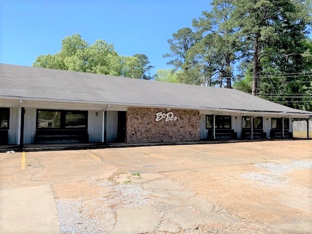
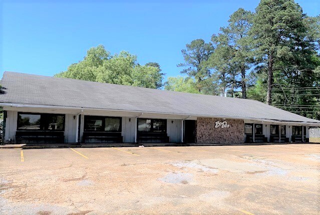
3790 S Highway 55 S
Jackson, MS
BEG W/L HWY 55 357.79 N OF N/L STOKES ROBERTSON RD WLY 220.2 FT NLY 228.9 FT E 290 .5 FT SWLY 265.05 FT TO POB BEING PT LOTS 8 & 9 THE MEADOWS
0862-0075-000
HINDS
Restaurantbuilding
Mississippi
C and X Area of minimal flood hazard, usually depicted on FIRMs as above the 500-year flood level.
8-9
2024
1 AC
2025
South Jackson
011103
Jackson
7,440 SF
NEARBY LISTINGS FOR SALE OR LEASE
DEMOGRAPHICS near 3790 S Highway 55 S
1 mile
3 mile
5 mile
2025 Total Population
2,911
23,707
66,179
2030 Population
2,860
23,035
64,771
Pop Growth 2025-2030
(1.75%)
(2.83%)
(2.13%)
Average Age
36
36
37
2025 Total Households
1,241
9,078
25,704
HH Growth 2025-2030
(2.01%)
(3.06%)
(2.19%)
Median Household Inc
$32,992
$45,466
$48,988
Avg Household Size
2.30
2.50
2.40
2025 Avg HH Vehicles
2.00
2.00
2.00
Median Home Value
$57,954
$91,631
$116,639
Median Year Built
1971
1967
1975
Nearby Places
Map Layers
Map Styles
 Street
 Aerial
Layers
 Traffic
 Biking
Places
Listings with unknown addresses are not visible on the map
- Restaurants
- Banks
- Shops
- Fitness
- Groceries
PUBLIC TRANSPORTATION
COMMUTER RAIL
Drive
Walk
Distance
9 min
5.2 mi
AIRPORT
Jackson-Medgar Wiley Evers International
Drive
Walk
Distance
Jackson-Medgar Wiley Evers International
21 min
13.8 mi
SALE & LEASE HISTORY
LISTING DATE
SALE/LEASE

Apr 05, 2021
For Sale
Nearby Properties
Address
Land Use
TOTAL SIZE
Lot Size
Zoning
Address
Land Use
TOTAL SIZE
Lot Size
Zoning
22,109 SF
1 AC
Address
Land Use
TOTAL SIZE
Lot Size
Zoning
224,684 SF
18 AC
Address
Land Use
TOTAL SIZE
Lot Size
Zoning
8.90 AC
Address
Land Use
TOTAL SIZE
Lot Size
Zoning
16,665 SF
1 AC
Address
Land Use
TOTAL SIZE
Lot Size
Zoning
Address
Land Use
TOTAL SIZE
Lot Size
Zoning
111,460 SF
9 AC
Address
Land Use
TOTAL SIZE
Lot Size
Zoning
28.48 AC
Address
Land Use
TOTAL SIZE
Lot Size
Zoning
14,075 SF
3.86 AC
Address
Land Use
TOTAL SIZE
Lot Size
Zoning
4,810 SF
28.82 AC
Address
Land Use
TOTAL SIZE
Lot Size
Zoning
18,881 SF
16.06 AC
Address
Land Use
TOTAL SIZE
Lot Size
Zoning
35,843 SF
20.15 AC
Address
Land Use
TOTAL SIZE
Lot Size
Zoning
236,500 SF
24 AC
Address
Land Use
TOTAL SIZE
Lot Size
Zoning
8.40 AC
Address
Land Use
TOTAL SIZE
Lot Size
Zoning
19,303 SF
10.42 AC
Address
Land Use
TOTAL SIZE
Lot Size
Zoning
62,842 SF
6.70 AC
Address
Land Use
TOTAL SIZE
Lot Size
Zoning
9.33 AC
Address
Land Use
TOTAL SIZE
Lot Size
Zoning
4,232 SF
12.03 AC
Address
Land Use
TOTAL SIZE
Lot Size
Zoning
3.59 AC
Address
Land Use
TOTAL SIZE
Lot Size
Zoning
6,000 SF
0.65 AC
Address
Land Use
TOTAL SIZE
Lot Size
Zoning
109,218 SF
8.86 AC
Address
Land Use
TOTAL SIZE
Lot Size
Zoning
Address
Land Use
TOTAL SIZE
Lot Size
Zoning
34.50 AC
Address
Land Use
TOTAL SIZE
Lot Size
Zoning
Address
Land Use
TOTAL SIZE
Lot Size
Zoning
86,732 SF
17.22 AC
Address
Land Use
TOTAL SIZE
Lot Size
Zoning
44,404 SF
5.11 AC
Address
Land Use
TOTAL SIZE
Lot Size
Zoning
95,894 SF
7.61 AC
Address
Land Use
TOTAL SIZE
Lot Size
Zoning
4.45 AC
Address
Land Use
TOTAL SIZE
Lot Size
Zoning
15,951 SF
3 AC
Address
Land Use
TOTAL SIZE
Lot Size
Zoning
32,738 SF
7.10 AC
The World's #1 Commercial Real Estate Marketplace
Connect with us
© 2026 CoStar Group
The information above has been obtained from sources believed reliable. While we do not doubt its accuracy we have not verified it and make no guarantee, warranty or representation about it. It is your responsibility to independently confirm its accuracy and completeness. Any projections, opinions, assumptions, or estimates used are for example only and do not represent the current or future performance of the property. The value of this transaction to you depends on tax and other factors which should be evaluated by your tax, financial, and legal advisors. You and your advisors should conduct a careful, independent investigation of the property to determine to your satisfaction the suitability of the property for your needs.