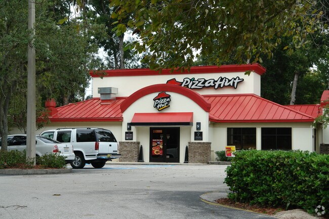
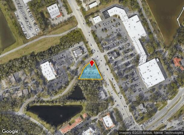
Property Record
3790 S Nova Rd, Port Orange, FL 32129


NEARBY LISTINGS FOR SALE OR LEASE
Property Detail
3790 S Nova Rd
Deltona-Daytona Beach-Ormond Beach, FL
Smith Commercial Sub Mb
6309-10-00-0020
LOT 2 EXC NEW R/W NOVA RD MYERS/SMITH COMMERCIAL SUB MB 39 PG 164 PER OR 2595 PG 0998 PER OR 6001 PGS 4246-4250 PER OR 6430 PG 3059 PER OR 8353 PG 2229
Storemultistory
Volusia
X
Florida
12127C0369J
2
2025
0.74 AC
2025
South Daytona Beach
082506
Deltona/Daytona Beach
2,964 SF
DEMOGRAPHICS near 3790 S Nova Rd
1 Mile
3 Mile
5 Mile
2024 Total Population
8,902
67,523
119,777
2029 Population
9,820
74,986
133,244
Pop Growth 2024-2029
+ 10.31%
+ 11.05%
+ 11.24%
Average Age
45
46
46
2024 Total Households
3,967
30,935
54,217
HH Growth 2024-2029
+ 10.36%
+ 11.37%
+ 11.73%
Median Household Inc
$52,054
$53,922
$54,420
Avg Household Size
2.10
2.10
2.10
2024 Avg HH Vehicles
2.00
2.00
2.00
Median Home Value
$220,219
$216,991
$244,608
Median Year Built
1985
1983
1984
Nearby Places
Map Layers
Map Styles
 Street
 Aerial
- Restaurants
- Banks
- Shops
- Fitness
- Groceries
PUBLIC TRANSPORTATION
AIRPORT
Daytona Beach International
DRIVE
WALK
Distance
Daytona Beach International
13 min
6.7 mi
Orlando Sanford International
DRIVE
WALK
Distance
Orlando Sanford International
53 min
37.6 mi
Freight Ports
Port Canaveral
DRIVE
WALK
Distance
Port Canaveral
78 min
66.2 mi
SALE & LEASE HISTORY
LISTING DATE
SALE/LEASE

Oct 11, 2021
For Sale
May 13, 2022
For Lease
Nearby Properties
Address
Land Use
TOTAL SIZE
Lot Size
Zoning
Address
Land Use
TOTAL SIZE
Lot Size
Zoning
490,775 SF
34.26 AC
01MH1
Address
Land Use
TOTAL SIZE
Lot Size
Zoning
396,385 SF
10 AC
01A2
Address
Land Use
TOTAL SIZE
Lot Size
Zoning
354,546 SF
24.71 AC
Address
Land Use
TOTAL SIZE
Lot Size
Zoning
448,867 SF
5.54 AC
Address
Land Use
TOTAL SIZE
Lot Size
Zoning
416,320 SF
0.13 AC
Address
Land Use
TOTAL SIZE
Lot Size
Zoning
13,965 SF
0.70 AC
MH1
Address
Land Use
TOTAL SIZE
Lot Size
Zoning
408,078 SF
50.07 AC
Address
Land Use
TOTAL SIZE
Lot Size
Zoning
330,883 SF
19.59 AC
Address
Land Use
TOTAL SIZE
Lot Size
Zoning
325,744 SF
12.23 AC
Address
Land Use
TOTAL SIZE
Lot Size
Zoning
300,516 SF
70 AC
A2
Address
Land Use
TOTAL SIZE
Lot Size
Zoning
379,591 SF
21.62 AC
MH1
Address
Land Use
TOTAL SIZE
Lot Size
Zoning
306,467 SF
20.76 AC
Address
Land Use
TOTAL SIZE
Lot Size
Zoning
10,360 SF
1.56 AC
Address
Land Use
TOTAL SIZE
Lot Size
Zoning
150,197 SF
16.07 AC
Address
Land Use
TOTAL SIZE
Lot Size
Zoning
94,338 SF
7.39 AC
Address
Land Use
TOTAL SIZE
Lot Size
Zoning
412,064 SF
60 AC
Address
Land Use
TOTAL SIZE
Lot Size
Zoning
60,449 SF
7.14 AC
16PCD
Address
Land Use
TOTAL SIZE
Lot Size
Zoning
184,242 SF
14.43 AC
Address
Land Use
TOTAL SIZE
Lot Size
Zoning
9,952 SF
9.30 AC
16RMH
Address
Land Use
TOTAL SIZE
Lot Size
Zoning
201,947 SF
0.23 AC
Address
Land Use
TOTAL SIZE
Lot Size
Zoning
269,160 SF
72.17 AC
16A
Address
Land Use
TOTAL SIZE
Lot Size
Zoning
156,994 SF
47.82 AC
16A
Address
Land Use
TOTAL SIZE
Lot Size
Zoning
155,590 SF
11.08 AC
16R3H
Address
Land Use
TOTAL SIZE
Lot Size
Zoning
8,355 SF
1 AC
MH1
Address
Land Use
TOTAL SIZE
Lot Size
Zoning
9,061 SF
0.23 AC
16RMH
Address
Land Use
TOTAL SIZE
Lot Size
Zoning
148,848 SF
9.99 AC
16R3H
Address
Land Use
TOTAL SIZE
Lot Size
Zoning
3,886 SF
3.99 AC
16RMH
Address
Land Use
TOTAL SIZE
Lot Size
Zoning
229,029 SF
0.43 AC
16PUD
Address
Land Use
TOTAL SIZE
Lot Size
Zoning
173,765 SF
0.32 AC
Address
Land Use
TOTAL SIZE
Lot Size
Zoning
9,833 SF
52.38 AC
16RMH
The World's #1 Commercial Real Estate Marketplace
Connect with us
© 2025 CoStar Group
The information above has been obtained from sources believed reliable. While we do not doubt its accuracy we have not verified it and make no guarantee, warranty or representation about it. It is your responsibility to independently confirm its accuracy and completeness. Any projections, opinions, assumptions, or estimates used are for example only and do not represent the current or future performance of the property. The value of this transaction to you depends on tax and other factors which should be evaluated by your tax, financial, and legal advisors. You and your advisors should conduct a careful, independent investigation of the property to determine to your satisfaction the suitability of the property for your needs.