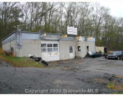
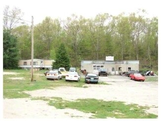
Property Record
37A Mill Rd, Foster, RI 02825

Property Detail
37A Mill Rd
FOST-000012-000000-000006
PROVIDENCE
Commercialnec
Rhode Island
30
6
B and X Area of moderate flood hazard, usually the area between the limits of the 100-year and 500-year floods.
4.63 AC
2025
Foster/Scituate
2025
Providence
013300
Providence-Warwick, RI-MA
1,008 SF
NEARBY LISTINGS FOR SALE OR LEASE
-
-
View all Foster listings for sale on LoopNet.com
DEMOGRAPHICS near 37A Mill Rd
1 mile
3 mile
5 mile
2025 Total Population
364
2,914
8,963
2030 Population
370
2,993
9,244
Pop Growth 2025-2030
+ 1.65%
+ 2.71%
+ 3.14%
Average Age
45
45
45
2025 Total Households
142
1,130
3,470
HH Growth 2025-2030
+ 2.11%
+ 2.57%
+ 3.05%
Median Household Inc
$112,500
$110,609
$108,564
Avg Household Size
2.50
2.50
2.50
2025 Avg HH Vehicles
2.00
2.00
2.00
Median Home Value
$438,775
$428,267
$422,624
Median Year Built
1969
1973
1973
Nearby Places
Map Layers
Map Styles
 Street
 Aerial
Transit
 Traffic
 Biking
Places
Listings with unknown addresses are not visible on the map
- Restaurants
- Banks
- Shops
- Fitness
- Groceries
PUBLIC TRANSPORTATION
AIRPORT
Rhode Island Tf Green International
Drive
Walk
Distance
Rhode Island Tf Green International
41 min
26.0 mi
Worcester Regional
Drive
Walk
Distance
Worcester Regional
67 min
47.4 mi
Freight Ports
Port of Davisville, RI
Drive
Walk
Distance
Port of Davisville, RI
51 min
35.3 mi
Nearby Properties
Address
Land Use
TOTAL SIZE
Lot Size
Zoning
Address
Land Use
TOTAL SIZE
Lot Size
Zoning
50,170 SF
17.22 AC
30
Address
Land Use
TOTAL SIZE
Lot Size
Zoning
621.47 AC
30
Address
Land Use
TOTAL SIZE
Lot Size
Zoning
33,103 SF
7.16 AC
RR-1
Address
Land Use
TOTAL SIZE
Lot Size
Zoning
482 AC
30
Address
Land Use
TOTAL SIZE
Lot Size
Zoning
9,068 SF
40.01 AC
RR-1
Address
Land Use
TOTAL SIZE
Lot Size
Zoning
2,386 SF
19 AC
20
Address
Land Use
TOTAL SIZE
Lot Size
Zoning
196.07 AC
30
Address
Land Use
TOTAL SIZE
Lot Size
Zoning
196 AC
30
Address
Land Use
TOTAL SIZE
Lot Size
Zoning
161.15 AC
30
Address
Land Use
TOTAL SIZE
Lot Size
Zoning
7,648 SF
12.10 AC
RR-1
Address
Land Use
TOTAL SIZE
Lot Size
Zoning
4,528 SF
7.10 AC
1
Address
Land Use
TOTAL SIZE
Lot Size
Zoning
120 AC
30
Address
Land Use
TOTAL SIZE
Lot Size
Zoning
6,820 SF
4.56 AC
20
Address
Land Use
TOTAL SIZE
Lot Size
Zoning
9,828 SF
10.16 AC
1
Address
Land Use
TOTAL SIZE
Lot Size
Zoning
Address
Land Use
TOTAL SIZE
Lot Size
Zoning
864 SF
76.06 AC
30
Address
Land Use
TOTAL SIZE
Lot Size
Zoning
5,108 SF
4.56 AC
BG
Address
Land Use
TOTAL SIZE
Lot Size
Zoning
5,562 SF
0.14 AC
30
Address
Land Use
TOTAL SIZE
Lot Size
Zoning
80 AC
30
Address
Land Use
TOTAL SIZE
Lot Size
Zoning
3,472 SF
51.81 AC
30
Address
Land Use
TOTAL SIZE
Lot Size
Zoning
5,098 SF
1.31 AC
RR-1
Address
Land Use
TOTAL SIZE
Lot Size
Zoning
10.87 AC
RR-1
Address
Land Use
TOTAL SIZE
Lot Size
Zoning
1,696 SF
5 AC
1
Address
Land Use
TOTAL SIZE
Lot Size
Zoning
10.39 AC
RR-1
Address
Land Use
TOTAL SIZE
Lot Size
Zoning
12,108 SF
1.08 AC
BL V
Address
Land Use
TOTAL SIZE
Lot Size
Zoning
4,208 SF
0.50 AC
30
Address
Land Use
TOTAL SIZE
Lot Size
Zoning
1,560 SF
0.64 AC
30
Address
Land Use
TOTAL SIZE
Lot Size
Zoning
1,836 SF
174.44 AC
30
Address
Land Use
TOTAL SIZE
Lot Size
Zoning
2,016 SF
15.69 AC
30
Address
Land Use
TOTAL SIZE
Lot Size
Zoning
768 SF
5.30 AC
1
The World's #1 Commercial Real Estate Marketplace
Connect with us
© 2026 CoStar Group
The information above has been obtained from sources believed reliable. While we do not doubt its accuracy we have not verified it and make no guarantee, warranty or representation about it. It is your responsibility to independently confirm its accuracy and completeness. Any projections, opinions, assumptions, or estimates used are for example only and do not represent the current or future performance of the property. The value of this transaction to you depends on tax and other factors which should be evaluated by your tax, financial, and legal advisors. You and your advisors should conduct a careful, independent investigation of the property to determine to your satisfaction the suitability of the property for your needs.