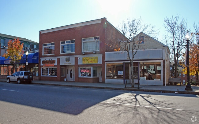
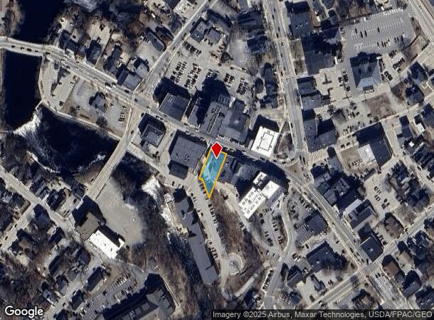
Property Record
42 N Main St, Rochester, NH 03867
NEARBY LISTINGS FOR SALE OR LEASE
Property Detail
42 N Main St
Commercialofficeresidentialmixeduse
Strafford
X
New Hampshire
33017C0211D
0.22 AC
2024
Strafford County
2024
Boston
084301
Boston-Cambridge-Newton, MA-NH
7,680 SF
RCHE-000121-000014
DEMOGRAPHICS near 42 N Main St
1 Mile
3 Mile
5 Mile
2024 Total Population
9,877
27,856
39,625
2029 Population
10,317
29,210
41,532
Pop Growth 2024-2029
+ 4.45%
+ 4.86%
+ 4.81%
Average Age
41
42
43
2024 Total Households
4,240
11,769
16,635
HH Growth 2024-2029
+ 4.58%
+ 4.93%
+ 4.87%
Median Household Inc
$69,329
$82,771
$85,363
Avg Household Size
2.20
2.30
2.30
2024 Avg HH Vehicles
2.00
2.00
2.00
Median Home Value
$233,988
$249,022
$252,581
Median Year Built
1951
1976
1980
Nearby Places
- Restaurants
- Banks
- Shops
- Fitness
- Groceries
PUBLIC TRANSPORTATION
AIRPORT
Portland International Jetport
DRIVE
WALK
Distance
Portland International Jetport
69 min
47.0 mi
Manchester Boston Regional
DRIVE
WALK
Distance
Manchester Boston Regional
66 min
47.3 mi
Nearby Properties
Address
Land Use
TOTAL SIZE
Lot Size
Zoning
Address
Land Use
TOTAL SIZE
Lot Size
Zoning
483,789 SF
37 AC
R2
Address
Land Use
TOTAL SIZE
Lot Size
Zoning
274,144 SF
73.08 AC
GRD
Address
Land Use
TOTAL SIZE
Lot Size
Zoning
Address
Land Use
TOTAL SIZE
Lot Size
Zoning
219,360 SF
6.23 AC
HSP
Address
Land Use
TOTAL SIZE
Lot Size
Zoning
277,667 SF
45.36 AC
HC
Address
Land Use
TOTAL SIZE
Lot Size
Zoning
79,192 SF
12.90 AC
R1
Address
Land Use
TOTAL SIZE
Lot Size
Zoning
207,125 SF
22 AC
R2
Address
Land Use
TOTAL SIZE
Lot Size
Zoning
1,273 SF
29.90 AC
R2
Address
Land Use
TOTAL SIZE
Lot Size
Zoning
224,153 SF
34.36 AC
GRD
Address
Land Use
TOTAL SIZE
Lot Size
Zoning
78,768 SF
10.92 AC
A
Address
Land Use
TOTAL SIZE
Lot Size
Zoning
86,420 SF
3.30 AC
DTC
Address
Land Use
TOTAL SIZE
Lot Size
Zoning
114,867 SF
17.23 AC
HC
Address
Land Use
TOTAL SIZE
Lot Size
Zoning
77,712 SF
10.99 AC
A
Address
Land Use
TOTAL SIZE
Lot Size
Zoning
9.53 AC
R1
Address
Land Use
TOTAL SIZE
Lot Size
Zoning
2.41 AC
Address
Land Use
TOTAL SIZE
Lot Size
Zoning
59,235 SF
22.08 AC
A
Address
Land Use
TOTAL SIZE
Lot Size
Zoning
97,792 SF
23.89 AC
R1
Address
Land Use
TOTAL SIZE
Lot Size
Zoning
68,535 SF
7.10 AC
R2
Address
Land Use
TOTAL SIZE
Lot Size
Zoning
236,340 SF
27.68 AC
HC
Address
Land Use
TOTAL SIZE
Lot Size
Zoning
58,500 SF
11.55 AC
R2
Address
Land Use
TOTAL SIZE
Lot Size
Zoning
111,807 SF
31.93 AC
HC
Address
Land Use
TOTAL SIZE
Lot Size
Zoning
49,146 SF
7.10 AC
R2
Address
Land Use
TOTAL SIZE
Lot Size
Zoning
221,995 SF
35.47 AC
IND
Address
Land Use
TOTAL SIZE
Lot Size
Zoning
13.34 AC
HC
Address
Land Use
TOTAL SIZE
Lot Size
Zoning
84,700 SF
5.76 AC
GRD
Address
Land Use
TOTAL SIZE
Lot Size
Zoning
53,517 SF
30 AC
A
Address
Land Use
TOTAL SIZE
Lot Size
Zoning
61,063 SF
8.26 AC
R2
Address
Land Use
TOTAL SIZE
Lot Size
Zoning
59,160 SF
10.44 AC
R1
Address
Land Use
TOTAL SIZE
Lot Size
Zoning
4,916 SF
93 AC
A
Address
Land Use
TOTAL SIZE
Lot Size
Zoning
82,752 SF
9.88 AC
R2
The World's #1 Commercial Real Estate Marketplace
Connect with us
© 2025 CoStar Group
The information above has been obtained from sources believed reliable. While we do not doubt its accuracy we have not verified it and make no guarantee, warranty or representation about it. It is your responsibility to independently confirm its accuracy and completeness. Any projections, opinions, assumptions, or estimates used are for example only and do not represent the current or future performance of the property. The value of this transaction to you depends on tax and other factors which should be evaluated by your tax, financial, and legal advisors. You and your advisors should conduct a careful, independent investigation of the property to determine to your satisfaction the suitability of the property for your needs.