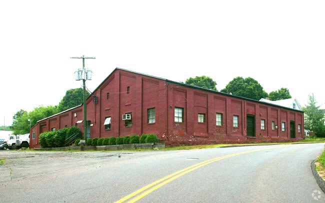
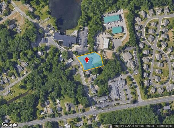
Property Record
38 Addison Rd, Glastonbury, CT 06033

NEARBY LISTINGS FOR SALE OR LEASE
Property Detail
38 Addison Rd
GLAS-000005F-000020-E000006
Hartford
Industrialgeneral
Connecticut
X
e0006
09003C0529F
0.60 AC
2025
Glastonbury
2025
Hartford
520100
Hartford-West Hartford-East Hartford, CT
10,480 SF
DEMOGRAPHICS near 38 Addison Rd
1 Mile
3 Mile
5 Mile
2024 Total Population
4,872
40,983
114,612
2029 Population
4,860
40,734
114,084
Pop Growth 2024-2029
(0.25%)
(0.61%)
(0.46%)
Average Age
43
43
41
2024 Total Households
2,029
16,325
46,643
HH Growth 2024-2029
(0.49%)
(0.72%)
(0.50%)
Median Household Inc
$114,062
$109,056
$81,487
Avg Household Size
2.30
2.40
2.40
2024 Avg HH Vehicles
2.00
2.00
2.00
Median Home Value
$329,225
$288,988
$258,959
Median Year Built
1978
1968
1963
Nearby Places
Map Layers
Map Styles
 Street
 Aerial
- Restaurants
- Banks
- Shops
- Fitness
- Groceries
PUBLIC TRANSPORTATION
COMMUTER RAIL
DRIVE
WALK
Distance
13 min
7.5 mi
DRIVE
WALK
Distance
13 min
7.5 mi
AIRPORT
Bradley International
DRIVE
WALK
Distance
Bradley International
35 min
21.3 mi
Tweed/New Haven
DRIVE
WALK
Distance
Tweed/New Haven
59 min
41.4 mi
Freight Ports
Port of New Haven
DRIVE
WALK
Distance
Port of New Haven
54 min
40.3 mi
Nearby Properties
Address
Land Use
TOTAL SIZE
Lot Size
Zoning
Address
Land Use
TOTAL SIZE
Lot Size
Zoning
49,219 SF
31.72 AC
Address
Land Use
TOTAL SIZE
Lot Size
Zoning
55.64 AC
Address
Land Use
TOTAL SIZE
Lot Size
Zoning
348,943 SF
51.21 AC
R-2
Address
Land Use
TOTAL SIZE
Lot Size
Zoning
188,454 SF
178.60 AC
A
Address
Land Use
TOTAL SIZE
Lot Size
Zoning
7.07 AC
PBD
Address
Land Use
TOTAL SIZE
Lot Size
Zoning
Address
Land Use
TOTAL SIZE
Lot Size
Zoning
11.95 AC
PAD
Address
Land Use
TOTAL SIZE
Lot Size
Zoning
15.12 AC
PAD
Address
Land Use
TOTAL SIZE
Lot Size
Zoning
Address
Land Use
TOTAL SIZE
Lot Size
Zoning
8.14 AC
Address
Land Use
TOTAL SIZE
Lot Size
Zoning
20.36 AC
B-1
Address
Land Use
TOTAL SIZE
Lot Size
Zoning
158,692 SF
2.89 AC
PAD
Address
Land Use
TOTAL SIZE
Lot Size
Zoning
105,294 SF
2.49 AC
PAD
Address
Land Use
TOTAL SIZE
Lot Size
Zoning
7.90 AC
Address
Land Use
TOTAL SIZE
Lot Size
Zoning
96,206 SF
2.83 AC
PAD
Address
Land Use
TOTAL SIZE
Lot Size
Zoning
3.06 AC
Address
Land Use
TOTAL SIZE
Lot Size
Zoning
71,728 SF
13.65 AC
Address
Land Use
TOTAL SIZE
Lot Size
Zoning
110,628 SF
28.81 AC
RR
Address
Land Use
TOTAL SIZE
Lot Size
Zoning
20,472 SF
10.59 AC
Address
Land Use
TOTAL SIZE
Lot Size
Zoning
5,603 SF
32.01 AC
Address
Land Use
TOTAL SIZE
Lot Size
Zoning
61,651 SF
9.98 AC
Address
Land Use
TOTAL SIZE
Lot Size
Zoning
50,648 SF
R-2
Address
Land Use
TOTAL SIZE
Lot Size
Zoning
57,457 SF
34.79 AC
Address
Land Use
TOTAL SIZE
Lot Size
Zoning
7.14 AC
Address
Land Use
TOTAL SIZE
Lot Size
Zoning
89,766 SF
11.18 AC
Address
Land Use
TOTAL SIZE
Lot Size
Zoning
55,045 SF
2.88 AC
Address
Land Use
TOTAL SIZE
Lot Size
Zoning
32,137 SF
11.95 AC
RR
Address
Land Use
TOTAL SIZE
Lot Size
Zoning
104,775 SF
12.57 AC
PI
Address
Land Use
TOTAL SIZE
Lot Size
Zoning
105,827 SF
5.85 AC
Address
Land Use
TOTAL SIZE
Lot Size
Zoning
104,702 SF
10 AC
PAD
The World's #1 Commercial Real Estate Marketplace
Connect with us
© 2025 CoStar Group
The information above has been obtained from sources believed reliable. While we do not doubt its accuracy we have not verified it and make no guarantee, warranty or representation about it. It is your responsibility to independently confirm its accuracy and completeness. Any projections, opinions, assumptions, or estimates used are for example only and do not represent the current or future performance of the property. The value of this transaction to you depends on tax and other factors which should be evaluated by your tax, financial, and legal advisors. You and your advisors should conduct a careful, independent investigation of the property to determine to your satisfaction the suitability of the property for your needs.