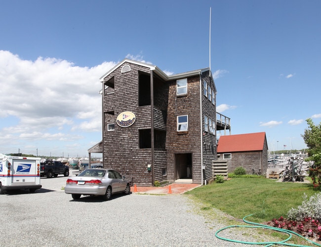
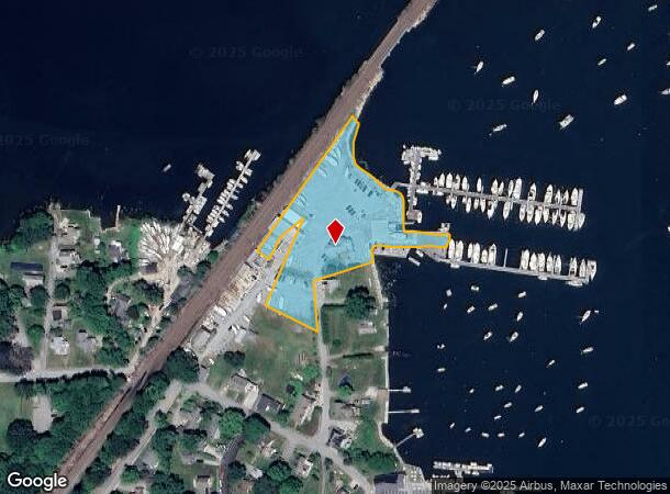
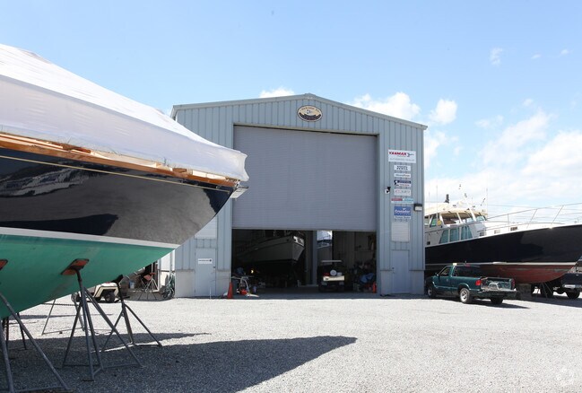
Property Record
38 Bayside Ave, Groton, CT 06340
NEARBY LISTINGS FOR SALE OR LEASE
Property Detail
38 Bayside Ave
Commercialnec
New London
AE
Connecticut
09011C0528J
2.34 AC
2025
SE New London
2025
Hartford
702900
Norwich-New London, CT
5,016 SF
GROT-002608-002091-008741
DEMOGRAPHICS near 38 Bayside Ave
1 Mile
3 Mile
5 Mile
2024 Total Population
2,088
14,309
38,734
2029 Population
2,125
14,507
39,109
Pop Growth 2024-2029
+ 1.77%
+ 1.38%
+ 0.97%
Average Age
51
48
45
2024 Total Households
979
6,331
17,602
HH Growth 2024-2029
+ 1.84%
+ 1.36%
+ 0.91%
Median Household Inc
$142,129
$107,156
$85,616
Avg Household Size
2.10
2.10
2.10
2024 Avg HH Vehicles
2.00
2.00
2.00
Median Home Value
$485,169
$435,472
$354,494
Median Year Built
1968
1964
1971
Nearby Places
Map Layers
Map Styles
 Street
 Aerial
- Restaurants
- Banks
- Shops
- Fitness
- Groceries
PUBLIC TRANSPORTATION
COMMUTER RAIL
New London (Shore Line East - Shore Line East)
DRIVE
WALK
Distance
New London (Shore Line East - Shore Line East)
11 min
6.5 mi
Freight Ports
Port of Davisville, RI
DRIVE
WALK
Distance
Port of Davisville, RI
1 min
35.7 mi
SALE & LEASE HISTORY
LISTING DATE
SALE/LEASE

Sep 25, 2016
For Lease
Nearby Properties
Address
Land Use
TOTAL SIZE
Lot Size
Zoning
Address
Land Use
TOTAL SIZE
Lot Size
Zoning
404.81 AC
GC
Address
Land Use
TOTAL SIZE
Lot Size
Zoning
8,820 SF
66.22 AC
R-12
Address
Land Use
TOTAL SIZE
Lot Size
Zoning
268,573 SF
74.66 AC
RS-20
Address
Land Use
TOTAL SIZE
Lot Size
Zoning
162,521 SF
44.19 AC
RS-20
Address
Land Use
TOTAL SIZE
Lot Size
Zoning
74,433 SF
47.37 AC
RS-20
Address
Land Use
TOTAL SIZE
Lot Size
Zoning
85,073 SF
17.60 AC
RA-20
Address
Land Use
TOTAL SIZE
Lot Size
Zoning
37,434 SF
10.75 AC
MVC
Address
Land Use
TOTAL SIZE
Lot Size
Zoning
7.40 AC
M-1
Address
Land Use
TOTAL SIZE
Lot Size
Zoning
59,024 SF
3.24 AC
RS-12
Address
Land Use
TOTAL SIZE
Lot Size
Zoning
19,274 SF
1.36 AC
GB-130
Address
Land Use
TOTAL SIZE
Lot Size
Zoning
39,386 SF
28.74 AC
RS-20
Address
Land Use
TOTAL SIZE
Lot Size
Zoning
10,056 SF
28.70 AC
R-12
Address
Land Use
TOTAL SIZE
Lot Size
Zoning
26,732 SF
12.44 AC
IM
Address
Land Use
TOTAL SIZE
Lot Size
Zoning
46,652 SF
12.23 AC
RC-120
Address
Land Use
TOTAL SIZE
Lot Size
Zoning
0.77 AC
DB-5
Address
Land Use
TOTAL SIZE
Lot Size
Zoning
35,520 SF
1.61 AC
MDD
Address
Land Use
TOTAL SIZE
Lot Size
Zoning
39,667 SF
8.41 AC
RS-20
Address
Land Use
TOTAL SIZE
Lot Size
Zoning
5,200 SF
7.12 AC
R-20
Address
Land Use
TOTAL SIZE
Lot Size
Zoning
3,072 SF
4.79 AC
WC
Address
Land Use
TOTAL SIZE
Lot Size
Zoning
7,500 SF
2.87 AC
MC-80
Address
Land Use
TOTAL SIZE
Lot Size
Zoning
20,992 SF
5.93 AC
RS-20
Address
Land Use
TOTAL SIZE
Lot Size
Zoning
11,858 SF
GB-130
Address
Land Use
TOTAL SIZE
Lot Size
Zoning
40,534 SF
20.84 AC
RC-120
Address
Land Use
TOTAL SIZE
Lot Size
Zoning
112,670 SF
10.24 AC
MVC
Address
Land Use
TOTAL SIZE
Lot Size
Zoning
60,503 SF
R-40
Address
Land Use
TOTAL SIZE
Lot Size
Zoning
22,500 SF
R-40
Address
Land Use
TOTAL SIZE
Lot Size
Zoning
3.80 AC
RM-15
Address
Land Use
TOTAL SIZE
Lot Size
Zoning
728 SF
2.67 AC
WC
Address
Land Use
TOTAL SIZE
Lot Size
Zoning
71,673 SF
4.30 AC
M-1
Address
Land Use
TOTAL SIZE
Lot Size
Zoning
36,369 SF
MDD
The World's #1 Commercial Real Estate Marketplace
Connect with us
© 2025 CoStar Group
The information above has been obtained from sources believed reliable. While we do not doubt its accuracy we have not verified it and make no guarantee, warranty or representation about it. It is your responsibility to independently confirm its accuracy and completeness. Any projections, opinions, assumptions, or estimates used are for example only and do not represent the current or future performance of the property. The value of this transaction to you depends on tax and other factors which should be evaluated by your tax, financial, and legal advisors. You and your advisors should conduct a careful, independent investigation of the property to determine to your satisfaction the suitability of the property for your needs.