Property Record
38 Browns Rd, Walden, NY 12586
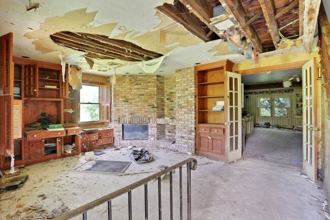

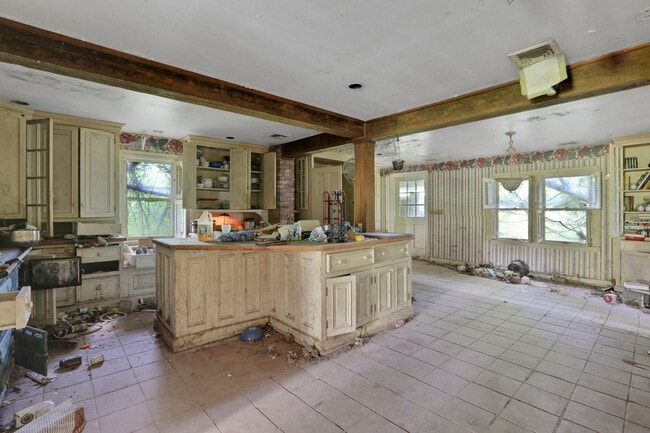
This Property Is For Sale
Property Detail
38 Browns Rd
333889-005-000-0001-041.000-0000
LT 2 KOVACS SUB MP 227-00CO HWY 1
Dairyfarm
ORANGE
AR
New York
A Areas with a 1% annual chance of flooding and a 26% chance of flooding over the life of a 30-year mortgage.
41.00
2024
88 AC
2024
Monroe
010602
Northern New Jersey
2,112 SF
Kiryas Joel-Poughkeepsie-Newburgh, NY
NEARBY LISTINGS FOR SALE OR LEASE
-
-
View all Walden listings for sale on LoopNet.com
DEMOGRAPHICS near 38 Browns Rd
1 mile
3 mile
5 mile
2025 Total Population
686
5,084
12,277
2030 Population
695
5,122
12,439
Pop Growth 2025-2030
+ 1.31%
+ 0.75%
+ 1.32%
Average Age
40
40
41
2025 Total Households
231
1,751
4,247
HH Growth 2025-2030
+ 1.30%
+ 0.69%
+ 1.34%
Median Household Inc
$140,202
$128,961
$120,899
Avg Household Size
2.90
2.90
2.80
2025 Avg HH Vehicles
3.00
2.00
2.00
Median Home Value
$400,658
$409,022
$408,795
Median Year Built
1984
1982
1983
Nearby Places
Map Layers
Map Styles
 Street
 Aerial
Transit
 Traffic
 Biking
Places
Listings with unknown addresses are not visible on the map
- Restaurants
- Banks
- Shops
- Fitness
- Groceries
PUBLIC TRANSPORTATION
AIRPORT
New York Stewart International
Drive
Walk
Distance
New York Stewart International
47 min
31.9 mi
Freight Ports
Port Newark Container Terminal
Drive
Walk
Distance
Port Newark Container Terminal
98 min
67.3 mi
Nearby Properties
Address
Land Use
TOTAL SIZE
Lot Size
Zoning
Address
Land Use
TOTAL SIZE
Lot Size
Zoning
10 AC
AR
Address
Land Use
TOTAL SIZE
Lot Size
Zoning
1,275 SF
10.40 AC
B4
Address
Land Use
TOTAL SIZE
Lot Size
Zoning
Address
Land Use
TOTAL SIZE
Lot Size
Zoning
18,180 SF
209.70 AC
BT
Address
Land Use
TOTAL SIZE
Lot Size
Zoning
0.23 AC
Address
Land Use
TOTAL SIZE
Lot Size
Zoning
44.30 AC
AR
Address
Land Use
TOTAL SIZE
Lot Size
Zoning
128.80 AC
AR
Address
Land Use
TOTAL SIZE
Lot Size
Zoning
7,922 SF
162.90 AC
AR
Address
Land Use
TOTAL SIZE
Lot Size
Zoning
70.10 AC
AR
Address
Land Use
TOTAL SIZE
Lot Size
Zoning
7,300 SF
4.70 AC
NC
Address
Land Use
TOTAL SIZE
Lot Size
Zoning
8,737 SF
9.50 AC
TC
Address
Land Use
TOTAL SIZE
Lot Size
Zoning
9.90 AC
Address
Land Use
TOTAL SIZE
Lot Size
Zoning
5,294 SF
150.40 AC
AR
Address
Land Use
TOTAL SIZE
Lot Size
Zoning
7,984 SF
3.60 AC
04100
Address
Land Use
TOTAL SIZE
Lot Size
Zoning
3,012 SF
85.40 AC
BT
Address
Land Use
TOTAL SIZE
Lot Size
Zoning
1,632 SF
91 AC
AR
Address
Land Use
TOTAL SIZE
Lot Size
Zoning
2,600 SF
179.80 AC
Address
Land Use
TOTAL SIZE
Lot Size
Zoning
16.80 AC
AR
Address
Land Use
TOTAL SIZE
Lot Size
Zoning
6,196 SF
24.50 AC
BT
Address
Land Use
TOTAL SIZE
Lot Size
Zoning
2,600 SF
175 AC
Address
Land Use
TOTAL SIZE
Lot Size
Zoning
54.40 AC
BT
Address
Land Use
TOTAL SIZE
Lot Size
Zoning
3,200 SF
0.93 AC
DSC
Address
Land Use
TOTAL SIZE
Lot Size
Zoning
2,002 SF
74.60 AC
AR
Address
Land Use
TOTAL SIZE
Lot Size
Zoning
3,264 SF
101.50 AC
AR
Address
Land Use
TOTAL SIZE
Lot Size
Zoning
2,108 SF
32.70 AC
AR
Address
Land Use
TOTAL SIZE
Lot Size
Zoning
4,748 SF
24.30 AC
AR
Address
Land Use
TOTAL SIZE
Lot Size
Zoning
3,842 SF
152 AC
BT
Address
Land Use
TOTAL SIZE
Lot Size
Zoning
3,340 SF
122.30 AC
AR
Address
Land Use
TOTAL SIZE
Lot Size
Zoning
2,440 SF
92 AC
AR
Address
Land Use
TOTAL SIZE
Lot Size
Zoning
4,047 SF
88.50 AC
BT
The World's #1 Commercial Real Estate Marketplace
Connect with us
© 2026 CoStar Group
The information above has been obtained from sources believed reliable. While we do not doubt its accuracy we have not verified it and make no guarantee, warranty or representation about it. It is your responsibility to independently confirm its accuracy and completeness. Any projections, opinions, assumptions, or estimates used are for example only and do not represent the current or future performance of the property. The value of this transaction to you depends on tax and other factors which should be evaluated by your tax, financial, and legal advisors. You and your advisors should conduct a careful, independent investigation of the property to determine to your satisfaction the suitability of the property for your needs.