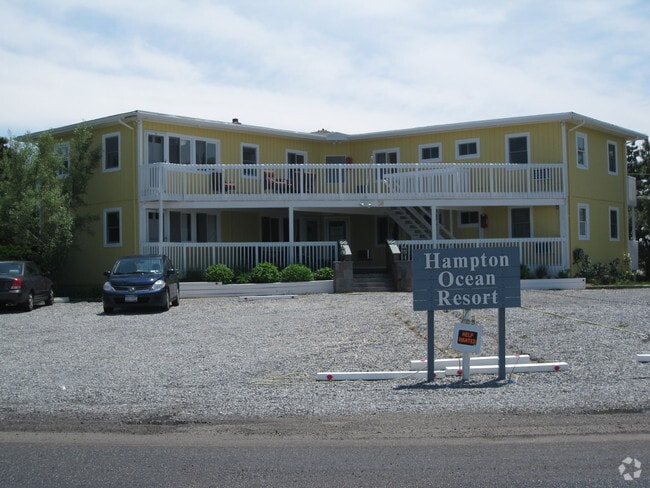
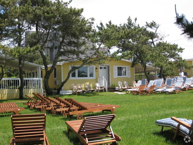
Property Record
38 Dune Ln, Westhampton Beach, NY 11978


NEARBY LISTINGS FOR SALE OR LEASE
Property Detail
38 Dune Ln
Nassau County-Suffolk County, NY
Map Proposed Subdivision Section Three
0900-386-00-02-00-014-001
ALSO INC 386-1-14.1
Apartment
Suffolk
VE
New York
36103C0783H
14
0
1.40 AC
2024
Outlying Eastern Suffolk
190502
Long Island (New York)
7,298 SF
DEMOGRAPHICS near 38 Dune Ln
1 Mile
3 Mile
5 Mile
2024 Total Population
2
11,361
26,060
2029 Population
3
11,708
26,684
Pop Growth 2024-2029
+ 50.00%
+ 3.05%
+ 2.39%
Average Age
0
43
42
2024 Total Households
1
4,391
9,769
HH Growth 2024-2029
0.00%
+ 3.03%
+ 2.28%
Median Household Inc
$0
$103,593
$108,214
Avg Household Size
.00
2.50
2.60
2024 Avg HH Vehicles
2.00
2.00
2.00
Median Home Value
$0
$730,895
$740,100
Median Year Built
0
1973
1974
Nearby Places
Map Layers
Map Styles
 Street
 Aerial
- Restaurants
- Banks
- Shops
- Fitness
- Groceries
PUBLIC TRANSPORTATION
COMMUTER RAIL
Hampton Bays Station (Montauk Branch - Long Island Rail Road)
DRIVE
WALK
Distance
Hampton Bays Station (Montauk Branch - Long Island Rail Road)
12 min
5.7 mi
Westhampton Station (Montauk Branch - Long Island Rail Road)
DRIVE
WALK
Distance
Westhampton Station (Montauk Branch - Long Island Rail Road)
17 min
7.5 mi
AIRPORT
Long Island MacArthur
DRIVE
WALK
Distance
Long Island MacArthur
56 min
33.1 mi
Nearby Properties
Address
Land Use
TOTAL SIZE
Lot Size
Zoning
Address
Land Use
TOTAL SIZE
Lot Size
Zoning
11,129 SF
2.40 AC
R80
Address
Land Use
TOTAL SIZE
Lot Size
Zoning
6.28 AC
R80
Address
Land Use
TOTAL SIZE
Lot Size
Zoning
2,947 SF
8.59 AC
VILLA
Address
Land Use
TOTAL SIZE
Lot Size
Zoning
12,001 SF
2.80 AC
VILLA
Address
Land Use
TOTAL SIZE
Lot Size
Zoning
9,952 SF
2.30 AC
VILLA
Address
Land Use
TOTAL SIZE
Lot Size
Zoning
8,418 SF
2.40 AC
R80
Address
Land Use
TOTAL SIZE
Lot Size
Zoning
2.04 AC
VILLA
Address
Land Use
TOTAL SIZE
Lot Size
Zoning
9.30 AC
R80
Address
Land Use
TOTAL SIZE
Lot Size
Zoning
12.90 AC
R80
Address
Land Use
TOTAL SIZE
Lot Size
Zoning
24,396 SF
7.60 AC
R80
Address
Land Use
TOTAL SIZE
Lot Size
Zoning
30,124 SF
10.20 AC
R20
Address
Land Use
TOTAL SIZE
Lot Size
Zoning
3.76 AC
R80
Address
Land Use
TOTAL SIZE
Lot Size
Zoning
150 SF
22.20 AC
R40
Address
Land Use
TOTAL SIZE
Lot Size
Zoning
1.34 AC
R80
Address
Land Use
TOTAL SIZE
Lot Size
Zoning
13,420 SF
2.05 AC
VILLA
Address
Land Use
TOTAL SIZE
Lot Size
Zoning
5.39 AC
VILLA
Address
Land Use
TOTAL SIZE
Lot Size
Zoning
2,400 SF
0.87 AC
R80
Address
Land Use
TOTAL SIZE
Lot Size
Zoning
6.47 AC
VILLA
Address
Land Use
TOTAL SIZE
Lot Size
Zoning
45,450 SF
3.38 AC
VILLA
Address
Land Use
TOTAL SIZE
Lot Size
Zoning
5,722 SF
2.70 AC
VILLA
Address
Land Use
TOTAL SIZE
Lot Size
Zoning
19,399 SF
9.40 AC
R40
Address
Land Use
TOTAL SIZE
Lot Size
Zoning
5,857 SF
1.60 AC
VILLA
Address
Land Use
TOTAL SIZE
Lot Size
Zoning
12,058 SF
1.21 AC
VILLA
Address
Land Use
TOTAL SIZE
Lot Size
Zoning
4.50 AC
R20
Address
Land Use
TOTAL SIZE
Lot Size
Zoning
7,495 SF
7.13 AC
R20
Address
Land Use
TOTAL SIZE
Lot Size
Zoning
5,883 SF
1.02 AC
R40
Address
Land Use
TOTAL SIZE
Lot Size
Zoning
4,737 SF
2.80 AC
R20
Address
Land Use
TOTAL SIZE
Lot Size
Zoning
9,456 SF
1.73 AC
VILLA
Address
Land Use
TOTAL SIZE
Lot Size
Zoning
4,262 SF
1.22 AC
VILLA
Address
Land Use
TOTAL SIZE
Lot Size
Zoning
11,538 SF
1.55 AC
R20
The World's #1 Commercial Real Estate Marketplace
Connect with us
© 2026 CoStar Group
The information above has been obtained from sources believed reliable. While we do not doubt its accuracy we have not verified it and make no guarantee, warranty or representation about it. It is your responsibility to independently confirm its accuracy and completeness. Any projections, opinions, assumptions, or estimates used are for example only and do not represent the current or future performance of the property. The value of this transaction to you depends on tax and other factors which should be evaluated by your tax, financial, and legal advisors. You and your advisors should conduct a careful, independent investigation of the property to determine to your satisfaction the suitability of the property for your needs.