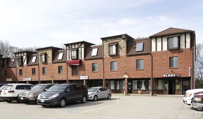
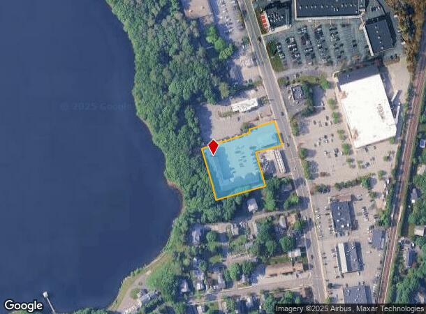
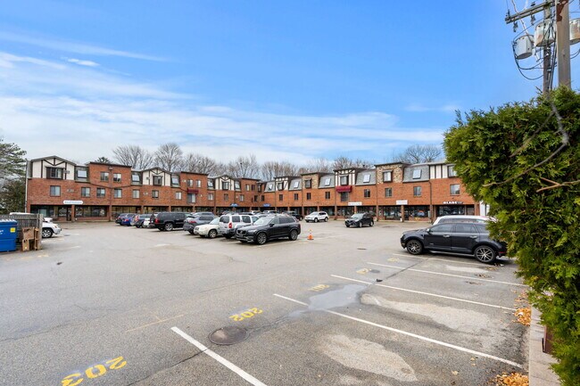
Property Record
38 Enon St, Beverly, MA 01915
NEARBY LISTINGS FOR SALE OR LEASE
Property Detail
38 Enon St
Commercialofficeresidentialmixeduse
Essex
X
Massachusetts
25009C0409G
1.35 AC
0
Beverly
2025
Boston
217102
Boston-Cambridge-Newton, MA-NH
46,036 SF
BEVE M:0080 B:0130 L:
DEMOGRAPHICS near 38 Enon St
1 mile
3 mile
5 mile
2024 Total Population
5,031
58,942
132,756
2029 Population
5,066
58,834
131,776
Pop Growth 2024-2029
+ 0.70%
(0.18%)
(0.74%)
Average Age
43
41
42
2024 Total Households
2,024
23,043
53,597
HH Growth 2024-2029
+ 0.69%
(0.26%)
(0.91%)
Median Household Inc
$93,488
$98,456
$89,162
Avg Household Size
2.40
2.40
2.30
2024 Avg HH Vehicles
2.00
2.00
2.00
Median Home Value
$620,757
$605,939
$572,597
Median Year Built
1972
1957
1956
Nearby Places
Map Layers
Map Styles
 Street
 Aerial
Transit
 Traffic
 Biking
Places
Listings with unknown addresses are not visible on the map
- Restaurants
- Banks
- Shops
- Fitness
- Groceries
PUBLIC TRANSPORTATION
COMMUTER RAIL
North Beverly (Newburyport/Rockport Line - Massachusetts Bay Transportation Authority Commuter Rail (Purple Line))
Drive
Walk
Distance
North Beverly (Newburyport/Rockport Line - Massachusetts Bay Transportation Authority Commuter Rail (Purple Line))
1 min
4 min
0.2 mi
Hamilton/Wenham (Newburyport/Rockport Line - Massachusetts Bay Transportation Authority Commuter Rail (Purple Line))
Drive
Walk
Distance
Hamilton/Wenham (Newburyport/Rockport Line - Massachusetts Bay Transportation Authority Commuter Rail (Purple Line))
6 min
2.4 mi
AIRPORT
General Edward Lawrence Logan International
Drive
Walk
Distance
General Edward Lawrence Logan International
35 min
19.6 mi
Freight Ports
Port of Boston
Drive
Walk
Distance
Port of Boston
40 min
25.4 mi
SALE & LEASE HISTORY
LISTING DATE
SALE/LEASE

Nov 17, 2022
For Lease
May 04, 2017
For Lease
Jun 16, 2020
For Lease
Jul 02, 2024
For Lease
Jan 16, 2020
For Lease
Apr 26, 2021
For Lease
Nearby Properties
Address
Land Use
TOTAL SIZE
Lot Size
Zoning
Address
Land Use
TOTAL SIZE
Lot Size
Zoning
48.89 AC
IG
Address
Land Use
TOTAL SIZE
Lot Size
Zoning
252,965 SF
56.44 AC
R3
Address
Land Use
TOTAL SIZE
Lot Size
Zoning
267,051 SF
41.08 AC
R10
Address
Land Use
TOTAL SIZE
Lot Size
Zoning
228,295 SF
12.50 AC
RMD
Address
Land Use
TOTAL SIZE
Lot Size
Zoning
231,509 SF
17.71 AC
R10
Address
Land Use
TOTAL SIZE
Lot Size
Zoning
172.50 AC
R3
Address
Land Use
TOTAL SIZE
Lot Size
Zoning
64,451 SF
102.50 AC
R1A
Address
Land Use
TOTAL SIZE
Lot Size
Zoning
182,122 SF
23.33 AC
R10
Address
Land Use
TOTAL SIZE
Lot Size
Zoning
207,237 SF
16.73 AC
RMD
Address
Land Use
TOTAL SIZE
Lot Size
Zoning
138,311 SF
56.04 AC
R45
Address
Land Use
TOTAL SIZE
Lot Size
Zoning
195,527 SF
16.60 AC
CG
Address
Land Use
TOTAL SIZE
Lot Size
Zoning
170,652 SF
23.73 AC
HD
Address
Land Use
TOTAL SIZE
Lot Size
Zoning
358,662 SF
36.98 AC
IR
Address
Land Use
TOTAL SIZE
Lot Size
Zoning
162,182 SF
9.53 AC
IR
Address
Land Use
TOTAL SIZE
Lot Size
Zoning
118,110 SF
0.67 AC
CC
Address
Land Use
TOTAL SIZE
Lot Size
Zoning
37,553 SF
238.29 AC
IR
Address
Land Use
TOTAL SIZE
Lot Size
Zoning
177,782 SF
12.21 AC
I2
Address
Land Use
TOTAL SIZE
Lot Size
Zoning
278,284 SF
23.20 AC
RSD
Address
Land Use
TOTAL SIZE
Lot Size
Zoning
112,023 SF
0.74 AC
CC
Address
Land Use
TOTAL SIZE
Lot Size
Zoning
123,171 SF
9.09 AC
R10
Address
Land Use
TOTAL SIZE
Lot Size
Zoning
91,168 SF
2.09 AC
CC
Address
Land Use
TOTAL SIZE
Lot Size
Zoning
139,582 SF
31.13 AC
R1
Address
Land Use
TOTAL SIZE
Lot Size
Zoning
64,845 SF
6.50 AC
RMD
Address
Land Use
TOTAL SIZE
Lot Size
Zoning
84,871 SF
0.96 AC
CC
Address
Land Use
TOTAL SIZE
Lot Size
Zoning
75,348 SF
1.35 AC
RMD
Address
Land Use
TOTAL SIZE
Lot Size
Zoning
207,095 SF
IR
Address
Land Use
TOTAL SIZE
Lot Size
Zoning
112,034 SF
1.06 AC
CC
Address
Land Use
TOTAL SIZE
Lot Size
Zoning
150,183 SF
38.84 AC
IR
Address
Land Use
TOTAL SIZE
Lot Size
Zoning
69,351 SF
0.49 AC
CC
Address
Land Use
TOTAL SIZE
Lot Size
Zoning
122,105 SF
12.96 AC
R10
The World's #1 Commercial Real Estate Marketplace
Connect with us
© 2026 CoStar Group
The information above has been obtained from sources believed reliable. While we do not doubt its accuracy we have not verified it and make no guarantee, warranty or representation about it. It is your responsibility to independently confirm its accuracy and completeness. Any projections, opinions, assumptions, or estimates used are for example only and do not represent the current or future performance of the property. The value of this transaction to you depends on tax and other factors which should be evaluated by your tax, financial, and legal advisors. You and your advisors should conduct a careful, independent investigation of the property to determine to your satisfaction the suitability of the property for your needs.