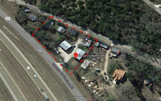
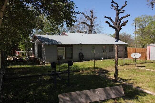
Property Record
38 Fm 289, Boerne, TX 78006

NEARBY LISTINGS FOR SALE OR LEASE
-
-
View all Boerne listings for lease on LoopNet.com
Property Detail
38 Fm 289
San Antonio-New Braunfels, TX
St Francis Subdivision
62297
ST FRANCIS SUBDIVISION LOT PT 6A, .4 ACRES
Commercialbuilding
Kendall
X
Texas
48265C0700F
6a
2024
0.40 AC
2025
Kendall County
970404
San Antonio
5,194 SF
DEMOGRAPHICS near 38 Fm 289
1 Mile
3 Mile
5 Mile
2024 Total Population
288
3,076
3,822
2029 Population
342
3,709
4,528
Pop Growth 2024-2029
+ 18.75%
+ 20.58%
+ 18.47%
Average Age
47
44
44
2024 Total Households
117
1,188
1,477
HH Growth 2024-2029
+ 18.80%
+ 20.88%
+ 18.89%
Median Household Inc
$54,782
$55,592
$56,666
Avg Household Size
2.40
2.50
2.50
2024 Avg HH Vehicles
2.00
2.00
2.00
Median Home Value
$436,111
$259,051
$273,404
Median Year Built
1977
1984
1986
Nearby Places
Map Layers
Map Styles
 Street
 Aerial
- Restaurants
- Banks
- Shops
- Fitness
- Groceries
PUBLIC TRANSPORTATION
AIRPORT
San Antonio International
DRIVE
WALK
Distance
San Antonio International
50 min
43.5 mi
SALE & LEASE HISTORY
LISTING DATE
SALE/LEASE

Mar 23, 2020
For Lease
Mar 20, 2020
For Sale
Nearby Properties
Address
Land Use
TOTAL SIZE
Lot Size
Zoning
Address
Land Use
TOTAL SIZE
Lot Size
Zoning
Address
Land Use
TOTAL SIZE
Lot Size
Zoning
108,917 SF
2.78 AC
Address
Land Use
TOTAL SIZE
Lot Size
Zoning
60,382 SF
11.44 AC
Address
Land Use
TOTAL SIZE
Lot Size
Zoning
79,798 SF
7.12 AC
Address
Land Use
TOTAL SIZE
Lot Size
Zoning
15,156 SF
11.40 AC
Address
Land Use
TOTAL SIZE
Lot Size
Zoning
15,001 SF
9.05 AC
Address
Land Use
TOTAL SIZE
Lot Size
Zoning
12,943 SF
4.39 AC
Address
Land Use
TOTAL SIZE
Lot Size
Zoning
23,792 SF
1.27 AC
Address
Land Use
TOTAL SIZE
Lot Size
Zoning
3,048 SF
178.94 AC
Address
Land Use
TOTAL SIZE
Lot Size
Zoning
2,722 SF
195.24 AC
Address
Land Use
TOTAL SIZE
Lot Size
Zoning
15,200 SF
0.40 AC
Address
Land Use
TOTAL SIZE
Lot Size
Zoning
1,542 SF
74.73 AC
Address
Land Use
TOTAL SIZE
Lot Size
Zoning
13,942 SF
1.68 AC
Address
Land Use
TOTAL SIZE
Lot Size
Zoning
7,690 SF
2.80 AC
Address
Land Use
TOTAL SIZE
Lot Size
Zoning
21,564 SF
6.02 AC
Address
Land Use
TOTAL SIZE
Lot Size
Zoning
9,236 SF
16 AC
Address
Land Use
TOTAL SIZE
Lot Size
Zoning
5.58 AC
Address
Land Use
TOTAL SIZE
Lot Size
Zoning
7,583 SF
22.66 AC
Address
Land Use
TOTAL SIZE
Lot Size
Zoning
10,237 SF
0.23 AC
Address
Land Use
TOTAL SIZE
Lot Size
Zoning
11,386 SF
13.38 AC
Address
Land Use
TOTAL SIZE
Lot Size
Zoning
16,662 SF
16.73 AC
Address
Land Use
TOTAL SIZE
Lot Size
Zoning
50,795 SF
19.83 AC
Address
Land Use
TOTAL SIZE
Lot Size
Zoning
3,200 SF
3 AC
Address
Land Use
TOTAL SIZE
Lot Size
Zoning
7,793 SF
0.60 AC
Address
Land Use
TOTAL SIZE
Lot Size
Zoning
6,700 SF
1.18 AC
Address
Land Use
TOTAL SIZE
Lot Size
Zoning
15,834 SF
3 AC
Address
Land Use
TOTAL SIZE
Lot Size
Zoning
3.74 AC
Address
Land Use
TOTAL SIZE
Lot Size
Zoning
76,226 SF
7.17 AC
Address
Land Use
TOTAL SIZE
Lot Size
Zoning
7,274 SF
0.33 AC
Address
Land Use
TOTAL SIZE
Lot Size
Zoning
26,804 SF
3.01 AC
The World's #1 Commercial Real Estate Marketplace
Connect with us
© 2026 CoStar Group
The information above has been obtained from sources believed reliable. While we do not doubt its accuracy we have not verified it and make no guarantee, warranty or representation about it. It is your responsibility to independently confirm its accuracy and completeness. Any projections, opinions, assumptions, or estimates used are for example only and do not represent the current or future performance of the property. The value of this transaction to you depends on tax and other factors which should be evaluated by your tax, financial, and legal advisors. You and your advisors should conduct a careful, independent investigation of the property to determine to your satisfaction the suitability of the property for your needs.