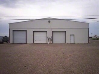
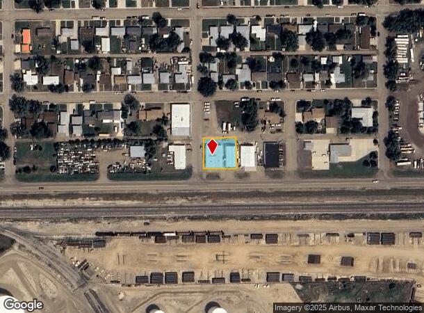
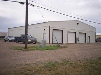
Property Record
38 Highway 200 S, Glendive, MT 59330
NEARBY LISTINGS FOR SALE OR LEASE
-
-
View all Glendive listings for sale on LoopNet.com
Property Detail
38 Highway 200 S
Other Market Areas
Forest Park Subd (Glendive)
16-2612-33-1-04-01-0000
FOREST PARK SUBD (GLENDIVE), S33, T16 N, R55 E, BLOCK 006, LOT 001, LOTS 1-2 W2 OF LOT 3
Commercialbuilding
Dawson
2025
Montana
2025
1-3
000200
0.29 AC
4,920 SF
Montana Other Areas
DEMOGRAPHICS near 38 Highway 200 S
1 Mile
3 Mile
5 Mile
2024 Total Population
1,084
6,510
7,721
2029 Population
1,060
6,448
7,638
Pop Growth 2024-2029
(2.21%)
(0.95%)
(1.07%)
Average Age
43
41
41
2024 Total Households
467
2,705
3,143
HH Growth 2024-2029
(2.36%)
(1.04%)
(1.18%)
Median Household Inc
$71,666
$59,016
$58,530
Avg Household Size
2.30
2.20
2.20
2024 Avg HH Vehicles
3.00
2.00
2.00
Median Home Value
$180,302
$166,490
$170,292
Median Year Built
1971
1969
1968
Nearby Places
Map Layers
Map Styles
 Street
 Aerial
- Restaurants
- Banks
- Shops
- Fitness
- Groceries
SALE & LEASE HISTORY
LISTING DATE
SALE/LEASE

Sep 24, 2016
For Sale
Nov 01, 2016
For Sale
Nearby Properties
Address
Land Use
TOTAL SIZE
Lot Size
Zoning
Address
Land Use
TOTAL SIZE
Lot Size
Zoning
76,538 SF
1.37 AC
2
Address
Land Use
TOTAL SIZE
Lot Size
Zoning
1,054 SF
34.75 AC
Address
Land Use
TOTAL SIZE
Lot Size
Zoning
17,410 SF
67.52 AC
Address
Land Use
TOTAL SIZE
Lot Size
Zoning
36,180 SF
43.44 AC
Address
Land Use
TOTAL SIZE
Lot Size
Zoning
22,153 SF
3.87 AC
2
Address
Land Use
TOTAL SIZE
Lot Size
Zoning
8,653 SF
0.68 AC
6
Address
Land Use
TOTAL SIZE
Lot Size
Zoning
36,592 SF
11.61 AC
6
Address
Land Use
TOTAL SIZE
Lot Size
Zoning
7,752 SF
0.27 AC
6
Address
Land Use
TOTAL SIZE
Lot Size
Zoning
9,700 SF
0.74 AC
6
Address
Land Use
TOTAL SIZE
Lot Size
Zoning
11,952 SF
2.13 AC
Address
Land Use
TOTAL SIZE
Lot Size
Zoning
11,264 SF
0.78 AC
2
Address
Land Use
TOTAL SIZE
Lot Size
Zoning
8,780 SF
2.07 AC
Address
Land Use
TOTAL SIZE
Lot Size
Zoning
9,345 SF
1.07 AC
Address
Land Use
TOTAL SIZE
Lot Size
Zoning
47,200 SF
7.34 AC
Address
Land Use
TOTAL SIZE
Lot Size
Zoning
28,480 SF
2.07 AC
3
Address
Land Use
TOTAL SIZE
Lot Size
Zoning
10,737 SF
4.49 AC
Address
Land Use
TOTAL SIZE
Lot Size
Zoning
9,165 SF
4.30 AC
Address
Land Use
TOTAL SIZE
Lot Size
Zoning
4,226 SF
2 AC
Address
Land Use
TOTAL SIZE
Lot Size
Zoning
6,832 SF
0.52 AC
3
Address
Land Use
TOTAL SIZE
Lot Size
Zoning
9,659 SF
1.43 AC
2
Address
Land Use
TOTAL SIZE
Lot Size
Zoning
10,797 SF
0.69 AC
1
Address
Land Use
TOTAL SIZE
Lot Size
Zoning
4,980 SF
0.16 AC
2
Address
Land Use
TOTAL SIZE
Lot Size
Zoning
5,862 SF
7.63 AC
Address
Land Use
TOTAL SIZE
Lot Size
Zoning
52,925 SF
6.85 AC
6
Address
Land Use
TOTAL SIZE
Lot Size
Zoning
12,540 SF
3.94 AC
Address
Land Use
TOTAL SIZE
Lot Size
Zoning
4,112 SF
0.34 AC
6
Address
Land Use
TOTAL SIZE
Lot Size
Zoning
20,644 SF
7.40 AC
Address
Land Use
TOTAL SIZE
Lot Size
Zoning
19,050 SF
4.93 AC
Address
Land Use
TOTAL SIZE
Lot Size
Zoning
15,776 SF
0.97 AC
3
Address
Land Use
TOTAL SIZE
Lot Size
Zoning
12,000 SF
9.24 AC
The World's #1 Commercial Real Estate Marketplace
Connect with us
© 2026 CoStar Group
The information above has been obtained from sources believed reliable. While we do not doubt its accuracy we have not verified it and make no guarantee, warranty or representation about it. It is your responsibility to independently confirm its accuracy and completeness. Any projections, opinions, assumptions, or estimates used are for example only and do not represent the current or future performance of the property. The value of this transaction to you depends on tax and other factors which should be evaluated by your tax, financial, and legal advisors. You and your advisors should conduct a careful, independent investigation of the property to determine to your satisfaction the suitability of the property for your needs.