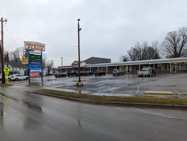
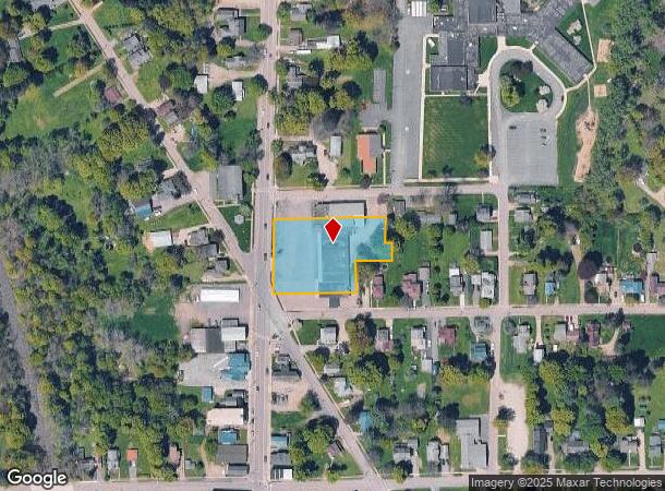
Property Record
38 N Main St, Delevan, NY 14042
NEARBY LISTINGS FOR SALE OR LEASE
-
-
View all Delevan listings for lease on LoopNet.com
Property Detail
38 N Main St
Other Market Areas
06 06 05
Olean, NY
Cattaraugus
048401-013-037-0001-002-000-0000
New York
Stripcommercialcenter
2.000
2025
1.21 AC
2024
New York West Area
960200
DEMOGRAPHICS near 38 N Main St
1 Mile
3 Mile
5 Mile
2024 Total Population
1,293
4,049
9,289
2029 Population
1,273
3,994
9,166
Pop Growth 2024-2029
(1.55%)
(1.36%)
(1.32%)
Average Age
42
42
43
2024 Total Households
552
1,764
3,962
HH Growth 2024-2029
(1.63%)
(1.42%)
(1.39%)
Median Household Inc
$50,694
$54,941
$56,473
Avg Household Size
2.30
2.30
2.30
2024 Avg HH Vehicles
2.00
2.00
2.00
Median Home Value
$80,212
$89,356
$118,032
Median Year Built
1978
1977
1975
Nearby Places
Map Layers
Map Styles
 Street
 Aerial
- Restaurants
- Banks
- Shops
- Fitness
- Groceries
PUBLIC TRANSPORTATION
AIRPORT
Buffalo Niagara International
DRIVE
WALK
Distance
Buffalo Niagara International
60 min
38.4 mi
SALE & LEASE HISTORY
LISTING DATE
SALE/LEASE

Sep 25, 2016
For Lease
Nov 29, 2017
For Sale
Jul 10, 2019
For Sale
Feb 02, 2022
For Lease
Aug 22, 2018
For Sale
Aug 07, 2017
For Lease
Nearby Properties
Address
Land Use
TOTAL SIZE
Lot Size
Zoning
Address
Land Use
TOTAL SIZE
Lot Size
Zoning
5,250 SF
3 AC
L1
Address
Land Use
TOTAL SIZE
Lot Size
Zoning
69.27 AC
AR
Address
Land Use
TOTAL SIZE
Lot Size
Zoning
46,173 SF
16.01 AC
Address
Land Use
TOTAL SIZE
Lot Size
Zoning
80,490 SF
8.09 AC
AG
Address
Land Use
TOTAL SIZE
Lot Size
Zoning
30.13 AC
C1
Address
Land Use
TOTAL SIZE
Lot Size
Zoning
3,648 SF
2.20 AC
CR
Address
Land Use
TOTAL SIZE
Lot Size
Zoning
11,500 SF
13.48 AC
07 - MIXED
Address
Land Use
TOTAL SIZE
Lot Size
Zoning
11,340 SF
2.65 AC
01 - NOT Z
Address
Land Use
TOTAL SIZE
Lot Size
Zoning
17,400 SF
4.55 AC
07 - MIXED
Address
Land Use
TOTAL SIZE
Lot Size
Zoning
7,590 SF
3.59 AC
Address
Land Use
TOTAL SIZE
Lot Size
Zoning
1,000 SF
50.85 AC
01 - NOT Z
Address
Land Use
TOTAL SIZE
Lot Size
Zoning
7,608 SF
5.77 AC
AG
Address
Land Use
TOTAL SIZE
Lot Size
Zoning
4,000 SF
14.53 AC
Address
Land Use
TOTAL SIZE
Lot Size
Zoning
4,000 SF
2.32 AC
07 - MIXED
Address
Land Use
TOTAL SIZE
Lot Size
Zoning
135.26 AC
AG
Address
Land Use
TOTAL SIZE
Lot Size
Zoning
4,970 SF
3.44 AC
01 - NOT Z
Address
Land Use
TOTAL SIZE
Lot Size
Zoning
12,000 SF
95.20 AC
01 - NOT Z
Address
Land Use
TOTAL SIZE
Lot Size
Zoning
2.55 AC
HC
Address
Land Use
TOTAL SIZE
Lot Size
Zoning
5,610 SF
1.05 AC
Address
Land Use
TOTAL SIZE
Lot Size
Zoning
12.85 AC
AR
Address
Land Use
TOTAL SIZE
Lot Size
Zoning
196.75 AC
01 - NOT Z
Address
Land Use
TOTAL SIZE
Lot Size
Zoning
135.30 AC
04 - FARM
Address
Land Use
TOTAL SIZE
Lot Size
Zoning
54.82 AC
AR
Address
Land Use
TOTAL SIZE
Lot Size
Zoning
0.01 AC
Address
Land Use
TOTAL SIZE
Lot Size
Zoning
122.80 AC
01 - NOT Z
Address
Land Use
TOTAL SIZE
Lot Size
Zoning
4,800 SF
1.47 AC
01 - NOT Z
Address
Land Use
TOTAL SIZE
Lot Size
Zoning
17.98 AC
HC
Address
Land Use
TOTAL SIZE
Lot Size
Zoning
3,500 SF
1.86 AC
01 - NOT Z
Address
Land Use
TOTAL SIZE
Lot Size
Zoning
3,740 SF
1.05 AC
01 - NOT Z
Address
Land Use
TOTAL SIZE
Lot Size
Zoning
1.10 AC
HC
The World's #1 Commercial Real Estate Marketplace
Connect with us
© 2025 CoStar Group
The information above has been obtained from sources believed reliable. While we do not doubt its accuracy we have not verified it and make no guarantee, warranty or representation about it. It is your responsibility to independently confirm its accuracy and completeness. Any projections, opinions, assumptions, or estimates used are for example only and do not represent the current or future performance of the property. The value of this transaction to you depends on tax and other factors which should be evaluated by your tax, financial, and legal advisors. You and your advisors should conduct a careful, independent investigation of the property to determine to your satisfaction the suitability of the property for your needs.