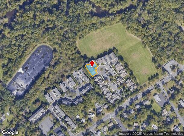
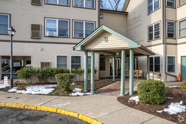
Property Record
38 Park Edge, Berkeley Heights, NJ 07922


NEARBY LISTINGS FOR SALE OR LEASE
Property Detail
38 Park Edge
01-00301-15-00001-0000-CONDO
Park Edge Bldg 08
Apartment
Union
X
New Jersey
34039C0007F
1
2024
0.23 AC
2025
Western Union County
038202
Northern New Jersey
26,328 SF
Newark, NJ-PA
DEMOGRAPHICS near 38 Park Edge
1 Mile
3 Mile
5 Mile
2024 Total Population
8,048
44,207
170,254
2029 Population
8,107
44,101
169,467
Pop Growth 2024-2029
+ 0.73%
(0.24%)
(0.46%)
Average Age
42
42
40
2024 Total Households
2,800
15,560
57,990
HH Growth 2024-2029
+ 0.57%
(0.55%)
(0.58%)
Median Household Inc
$147,546
$169,812
$143,806
Avg Household Size
2.80
2.80
2.80
2024 Avg HH Vehicles
2.00
2.00
2.00
Median Home Value
$719,649
$741,671
$720,454
Median Year Built
1967
1965
1958
Nearby Places
Map Layers
Map Styles
 Street
 Aerial
- Restaurants
- Banks
- Shops
- Fitness
- Groceries
PUBLIC TRANSPORTATION
COMMUTER RAIL
Berkeley Heights (Morris & Essex Gladstone Branch - NJ Transit Commuter Rail (NJ Transit))
DRIVE
WALK
Distance
Berkeley Heights (Morris & Essex Gladstone Branch - NJ Transit Commuter Rail (NJ Transit))
2 min
19 min
1.0 mi
Murray Hill (Morris & Essex Gladstone Branch - NJ Transit Commuter Rail (NJ Transit))
DRIVE
WALK
Distance
Murray Hill (Morris & Essex Gladstone Branch - NJ Transit Commuter Rail (NJ Transit))
5 min
2.0 mi
AIRPORT
Newark Liberty International
DRIVE
WALK
Distance
Newark Liberty International
25 min
18.6 mi
LaGuardia
DRIVE
WALK
Distance
LaGuardia
59 min
37.9 mi
Freight Ports
New York Container Terminal
DRIVE
WALK
Distance
New York Container Terminal
35 min
21.5 mi
Nearby Properties
Address
Land Use
TOTAL SIZE
Lot Size
Zoning
Address
Land Use
TOTAL SIZE
Lot Size
Zoning
151,088 SF
26.48 AC
CCRC
Address
Land Use
TOTAL SIZE
Lot Size
Zoning
153.40 AC
OR
Address
Land Use
TOTAL SIZE
Lot Size
Zoning
439.33 AC
Address
Land Use
TOTAL SIZE
Lot Size
Zoning
0.42 AC
R-1
Address
Land Use
TOTAL SIZE
Lot Size
Zoning
47.69 AC
MU
Address
Land Use
TOTAL SIZE
Lot Size
Zoning
34.60 AC
MU
Address
Land Use
TOTAL SIZE
Lot Size
Zoning
140,732 SF
42.73 AC
OR
Address
Land Use
TOTAL SIZE
Lot Size
Zoning
23.93 AC
B2
Address
Land Use
TOTAL SIZE
Lot Size
Zoning
24.92 AC
MU
Address
Land Use
TOTAL SIZE
Lot Size
Zoning
61,912 SF
16 AC
OR
Address
Land Use
TOTAL SIZE
Lot Size
Zoning
23.66 AC
R2
Address
Land Use
TOTAL SIZE
Lot Size
Zoning
356.94 AC
OL
Address
Land Use
TOTAL SIZE
Lot Size
Zoning
36.55 AC
OL
Address
Land Use
TOTAL SIZE
Lot Size
Zoning
184,000 SF
24.43 AC
OR
Address
Land Use
TOTAL SIZE
Lot Size
Zoning
6.76 AC
MU
Address
Land Use
TOTAL SIZE
Lot Size
Zoning
3,612 SF
7.92 AC
C
Address
Land Use
TOTAL SIZE
Lot Size
Zoning
16.30 AC
OR
Address
Land Use
TOTAL SIZE
Lot Size
Zoning
34.89 AC
R-1
Address
Land Use
TOTAL SIZE
Lot Size
Zoning
192 SF
8.68 AC
Address
Land Use
TOTAL SIZE
Lot Size
Zoning
218,207 SF
15.28 AC
Address
Land Use
TOTAL SIZE
Lot Size
Zoning
35.20 AC
OL
Address
Land Use
TOTAL SIZE
Lot Size
Zoning
9.53 AC
DD
Address
Land Use
TOTAL SIZE
Lot Size
Zoning
24.62 AC
CCRC
Address
Land Use
TOTAL SIZE
Lot Size
Zoning
Address
Land Use
TOTAL SIZE
Lot Size
Zoning
16.32 AC
R2
Address
Land Use
TOTAL SIZE
Lot Size
Zoning
Address
Land Use
TOTAL SIZE
Lot Size
Zoning
11.16 AC
R-3
Address
Land Use
TOTAL SIZE
Lot Size
Zoning
8.56 AC
R2
Address
Land Use
TOTAL SIZE
Lot Size
Zoning
27.24 AC
A-H
Address
Land Use
TOTAL SIZE
Lot Size
Zoning
13.40 AC
R2
The World's #1 Commercial Real Estate Marketplace
Connect with us
© 2025 CoStar Group
The information above has been obtained from sources believed reliable. While we do not doubt its accuracy we have not verified it and make no guarantee, warranty or representation about it. It is your responsibility to independently confirm its accuracy and completeness. Any projections, opinions, assumptions, or estimates used are for example only and do not represent the current or future performance of the property. The value of this transaction to you depends on tax and other factors which should be evaluated by your tax, financial, and legal advisors. You and your advisors should conduct a careful, independent investigation of the property to determine to your satisfaction the suitability of the property for your needs.