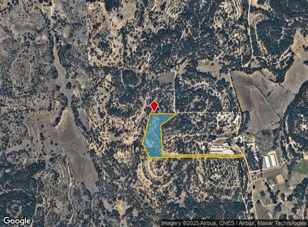
Property Record
36 Rust Ln, Boerne, TX 78006
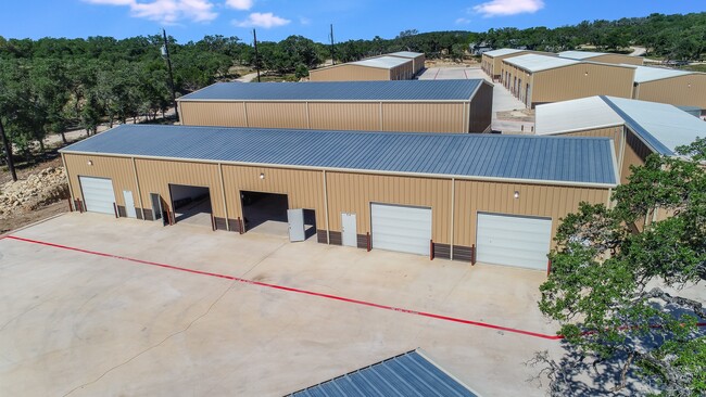
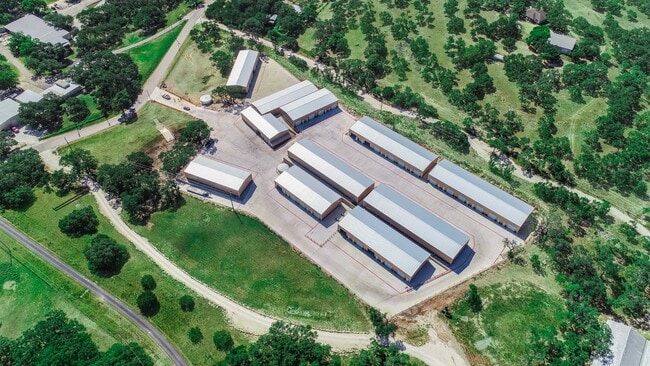
Property Detail
36 Rust Ln
15207
Survey 734 A Pfeiffer
Agriculturalland
A10388 - SURVEY 734 A PFEIFFER 15.677 ACRES, (INCLUDES JUAN ORTIZ S190 A363) (INCLUDES JUAN ORTIZ S190 A363)
X
Kendall
48259C0425F
Texas
2024
15.68 AC
2025
Kendall County
970403
San Antonio
8,225 SF
San Antonio-New Braunfels, TX
NEARBY LISTINGS FOR SALE OR LEASE
DEMOGRAPHICS near 36 Rust Ln
1 mile
3 mile
5 mile
2024 Total Population
68
2,831
25,955
2029 Population
83
3,533
32,633
Pop Growth 2024-2029
+ 22.06%
+ 24.80%
+ 25.73%
Average Age
46
43
41
2024 Total Households
26
990
9,329
HH Growth 2024-2029
+ 23.08%
+ 25.15%
+ 26.12%
Median Household Inc
$137,500
$130,357
$114,254
Avg Household Size
2.70
2.80
2.70
2024 Avg HH Vehicles
3.00
3.00
2.00
Median Home Value
$477,777
$493,986
$478,741
Median Year Built
1989
2005
2004
Nearby Places
Map Layers
Map Styles
 Street
 Aerial
Transit
 Traffic
 Biking
Places
Listings with unknown addresses are not visible on the map
- Restaurants
- Banks
- Shops
- Fitness
- Groceries
PUBLIC TRANSPORTATION
AIRPORT
San Antonio International
Drive
Walk
Distance
San Antonio International
47 min
34.2 mi
Freight Ports
Calhoun Port
Drive
Walk
Distance
Calhoun Port
226 min
185.8 mi
Nearby Properties
Address
Land Use
TOTAL SIZE
Lot Size
Zoning
Address
Land Use
TOTAL SIZE
Lot Size
Zoning
23,011 SF
61.71 AC
Address
Land Use
TOTAL SIZE
Lot Size
Zoning
166,650 SF
14.62 AC
Address
Land Use
TOTAL SIZE
Lot Size
Zoning
28,282 SF
11.78 AC
Address
Land Use
TOTAL SIZE
Lot Size
Zoning
46,506 SF
11.40 AC
Address
Land Use
TOTAL SIZE
Lot Size
Zoning
10,800 SF
13.12 AC
Address
Land Use
TOTAL SIZE
Lot Size
Zoning
16,700 SF
1.71 AC
Address
Land Use
TOTAL SIZE
Lot Size
Zoning
13,041 SF
10.44 AC
Address
Land Use
TOTAL SIZE
Lot Size
Zoning
72,325 SF
6.43 AC
Address
Land Use
TOTAL SIZE
Lot Size
Zoning
9,602 SF
16.68 AC
Address
Land Use
TOTAL SIZE
Lot Size
Zoning
8,932 SF
1.15 AC
Address
Land Use
TOTAL SIZE
Lot Size
Zoning
10,500 SF
1.23 AC
Address
Land Use
TOTAL SIZE
Lot Size
Zoning
8,716 SF
10.51 AC
Address
Land Use
TOTAL SIZE
Lot Size
Zoning
4,562 SF
11.14 AC
Address
Land Use
TOTAL SIZE
Lot Size
Zoning
32.21 AC
Address
Land Use
TOTAL SIZE
Lot Size
Zoning
8,952 SF
6.49 AC
Address
Land Use
TOTAL SIZE
Lot Size
Zoning
31,504 SF
2.10 AC
Address
Land Use
TOTAL SIZE
Lot Size
Zoning
28,705 SF
1.51 AC
Address
Land Use
TOTAL SIZE
Lot Size
Zoning
13,857 SF
2.49 AC
Address
Land Use
TOTAL SIZE
Lot Size
Zoning
7,169 SF
10.13 AC
Address
Land Use
TOTAL SIZE
Lot Size
Zoning
6,246 SF
7.17 AC
Address
Land Use
TOTAL SIZE
Lot Size
Zoning
6,837 SF
3.45 AC
Address
Land Use
TOTAL SIZE
Lot Size
Zoning
4,573 SF
18.20 AC
Address
Land Use
TOTAL SIZE
Lot Size
Zoning
6,198 SF
0.35 AC
Address
Land Use
TOTAL SIZE
Lot Size
Zoning
6,198 SF
0.35 AC
Address
Land Use
TOTAL SIZE
Lot Size
Zoning
4,562 SF
11.14 AC
Address
Land Use
TOTAL SIZE
Lot Size
Zoning
8,135 SF
8.14 AC
Address
Land Use
TOTAL SIZE
Lot Size
Zoning
9,076 SF
2.94 AC
Address
Land Use
TOTAL SIZE
Lot Size
Zoning
5,403 SF
5.02 AC
Address
Land Use
TOTAL SIZE
Lot Size
Zoning
12,887 SF
2.25 AC
Address
Land Use
TOTAL SIZE
Lot Size
Zoning
9,589 SF
3.99 AC
The World's #1 Commercial Real Estate Marketplace
Connect with us
© 2026 CoStar Group
The information above has been obtained from sources believed reliable. While we do not doubt its accuracy we have not verified it and make no guarantee, warranty or representation about it. It is your responsibility to independently confirm its accuracy and completeness. Any projections, opinions, assumptions, or estimates used are for example only and do not represent the current or future performance of the property. The value of this transaction to you depends on tax and other factors which should be evaluated by your tax, financial, and legal advisors. You and your advisors should conduct a careful, independent investigation of the property to determine to your satisfaction the suitability of the property for your needs.