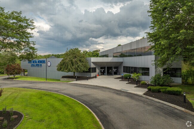
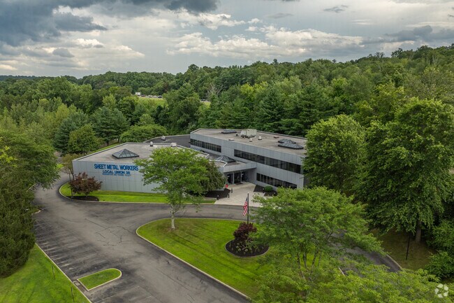
Property Record
38 Starr Ridge Rd, Brewster, NY 10509

Save to a Folder
{{folder.Name}}
{{folder.ListingIds.length}} Properties
{{folder.ListingIds.length}} Property
Create a New Folder
Property Detail
38 Starr Ridge Rd
373089-068-000-0002-061-000-0000
Putnam
Commercialnec
New York
SR 6
61.00
B and X Area of moderate flood hazard, usually the area between the limits of the 100-year and 500-year floods.
6.91 AC
2024
Brewster
2025
Westchester/So Connecticut
011700
New York-Jersey City-White Plains, NY-NJ
34,370 SF
NEARBY LISTINGS FOR SALE OR LEASE
DEMOGRAPHICS near 38 Starr Ridge Rd
1 mile
3 mile
5 mile
2025 Total Population
844
15,155
40,751
2030 Population
832
15,158
41,231
Pop Growth 2025-2030
(1.42%)
+ 0.02%
+ 1.18%
Average Age
43
43
44
2025 Total Households
304
5,769
15,790
HH Growth 2025-2030
(1.32%)
+ 0.24%
+ 1.37%
Median Household Inc
$127,500
$115,812
$120,604
Avg Household Size
2.70
2.60
2.50
2025 Avg HH Vehicles
2.00
2.00
2.00
Median Home Value
$576,772
$468,291
$499,662
Median Year Built
1969
1972
1981
Nearby Places
Map Layers
Map Styles
 Street
 Aerial
Layers
 Traffic
 Biking
Places
Listings with unknown addresses are not visible on the map
- Restaurants
- Banks
- Shops
- Fitness
- Groceries
PUBLIC TRANSPORTATION
COMMUTER RAIL
Brewster Station (Harlem Line - Metro-North Commuter Railroad Company (Metro-North))
Drive
Walk
Distance
Brewster Station (Harlem Line - Metro-North Commuter Railroad Company (Metro-North))
6 min
2.1 mi
Southeast Station (Harlem Line - Metro-North Commuter Railroad Company (Metro-North))
Drive
Walk
Distance
Southeast Station (Harlem Line - Metro-North Commuter Railroad Company (Metro-North))
15 min
5.9 mi
AIRPORT
Westchester County
Drive
Walk
Distance
Westchester County
35 min
26.5 mi
New York Stewart International
Drive
Walk
Distance
New York Stewart International
52 min
37.7 mi
Freight Ports
Port of New Haven
Drive
Walk
Distance
Port of New Haven
67 min
45.2 mi
Nearby Properties
Address
Land Use
TOTAL SIZE
Lot Size
Zoning
Address
Land Use
TOTAL SIZE
Lot Size
Zoning
23,091 SF
84.73 AC
R160
Address
Land Use
TOTAL SIZE
Lot Size
Zoning
1,078.50 AC
SR 6
Address
Land Use
TOTAL SIZE
Lot Size
Zoning
670.72 AC
SP Z
Address
Land Use
TOTAL SIZE
Lot Size
Zoning
5,328 SF
808.45 AC
R60
Address
Land Use
TOTAL SIZE
Lot Size
Zoning
47.39 AC
PND
Address
Land Use
TOTAL SIZE
Lot Size
Zoning
306.87 AC
SP Z
Address
Land Use
TOTAL SIZE
Lot Size
Zoning
32.98 AC
PND
Address
Land Use
TOTAL SIZE
Lot Size
Zoning
146,484 SF
23.06 AC
SR 22
Address
Land Use
TOTAL SIZE
Lot Size
Zoning
99,900 SF
21.48 AC
OP1
Address
Land Use
TOTAL SIZE
Lot Size
Zoning
Address
Land Use
TOTAL SIZE
Lot Size
Zoning
67.30 AC
Address
Land Use
TOTAL SIZE
Lot Size
Zoning
1.16 AC
SR 6
Address
Land Use
TOTAL SIZE
Lot Size
Zoning
42.30 AC
Address
Land Use
TOTAL SIZE
Lot Size
Zoning
22,338 SF
2.37 AC
C
Address
Land Use
TOTAL SIZE
Lot Size
Zoning
Address
Land Use
TOTAL SIZE
Lot Size
Zoning
2.03 AC
C
Address
Land Use
TOTAL SIZE
Lot Size
Zoning
59,257 SF
21 AC
SR 6
Address
Land Use
TOTAL SIZE
Lot Size
Zoning
3,060 SF
2.47 AC
R40
Address
Land Use
TOTAL SIZE
Lot Size
Zoning
116,593 SF
11.23 AC
HC
Address
Land Use
TOTAL SIZE
Lot Size
Zoning
63,221 SF
10 AC
SP Z
Address
Land Use
TOTAL SIZE
Lot Size
Zoning
66,037 SF
1.61 AC
R
Address
Land Use
TOTAL SIZE
Lot Size
Zoning
6,003 SF
35.29 AC
HC
Address
Land Use
TOTAL SIZE
Lot Size
Zoning
69.71 AC
Address
Land Use
TOTAL SIZE
Lot Size
Zoning
57,505 SF
11.75 AC
SR 6
Address
Land Use
TOTAL SIZE
Lot Size
Zoning
3,077 SF
10.66 AC
RMF
Address
Land Use
TOTAL SIZE
Lot Size
Zoning
48,443 SF
6.46 AC
SR 6
Address
Land Use
TOTAL SIZE
Lot Size
Zoning
109,516 SF
12.84 AC
SR 22
Address
Land Use
TOTAL SIZE
Lot Size
Zoning
163.38 AC
Address
Land Use
TOTAL SIZE
Lot Size
Zoning
173,168 SF
7.94 AC
HC
Address
Land Use
TOTAL SIZE
Lot Size
Zoning
122,160 SF
6.84 AC
OP1
The World's #1 Commercial Real Estate Marketplace
Connect with us
© 2026 CoStar Group
The information above has been obtained from sources believed reliable. While we do not doubt its accuracy we have not verified it and make no guarantee, warranty or representation about it. It is your responsibility to independently confirm its accuracy and completeness. Any projections, opinions, assumptions, or estimates used are for example only and do not represent the current or future performance of the property. The value of this transaction to you depends on tax and other factors which should be evaluated by your tax, financial, and legal advisors. You and your advisors should conduct a careful, independent investigation of the property to determine to your satisfaction the suitability of the property for your needs.