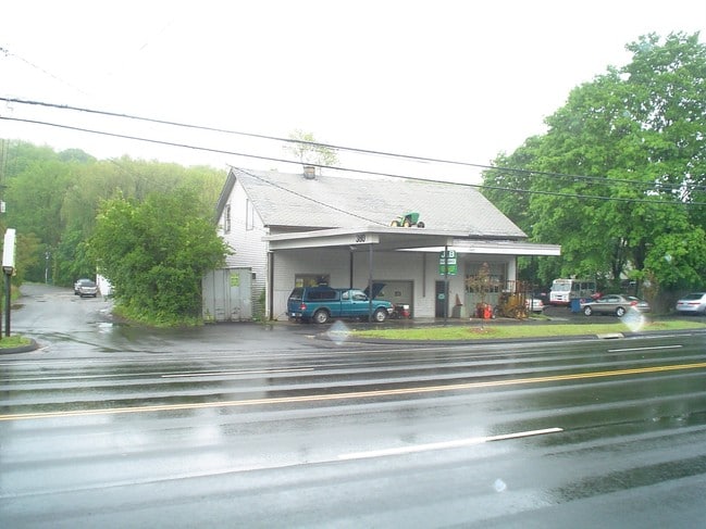
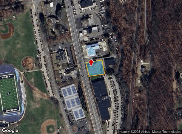
Property Record
380 Danbury Rd, Wilton, CT 06897

NEARBY LISTINGS FOR SALE OR LEASE
Property Detail
380 Danbury Rd
12 82
Far Mill River Condo
Commercialnec
Fairfield
AE
Connecticut
09001C0383F
0.48 AC
2025
Wilton
2025
Westchester/So Connecticut
045200
Bridgeport-Stamford-Danbury, CT
2,600 SF
DEMOGRAPHICS near 380 Danbury Rd
1 Mile
3 Mile
5 Mile
2024 Total Population
1,599
17,927
57,567
2029 Population
1,585
17,965
57,770
Pop Growth 2024-2029
(0.88%)
+ 0.21%
+ 0.35%
Average Age
43
41
41
2024 Total Households
497
5,986
20,352
HH Growth 2024-2029
(1.61%)
+ 0.10%
+ 0.32%
Median Household Inc
$215,985
$213,346
$190,496
Avg Household Size
2.90
2.90
2.80
2024 Avg HH Vehicles
2.00
2.00
2.00
Median Home Value
$887,018
$793,797
$792,008
Median Year Built
1974
1969
1969
Nearby Places
Map Layers
Map Styles
 Street
 Aerial
- Restaurants
- Banks
- Shops
- Fitness
- Groceries
PUBLIC TRANSPORTATION
AIRPORT
Westchester County
DRIVE
WALK
Distance
Westchester County
38 min
26.1 mi
Tweed/New Haven
DRIVE
WALK
Distance
Tweed/New Haven
57 min
37.7 mi
Nearby Properties
Address
Land Use
TOTAL SIZE
Lot Size
Zoning
Address
Land Use
TOTAL SIZE
Lot Size
Zoning
28.64 AC
DE-10
Address
Land Use
TOTAL SIZE
Lot Size
Zoning
82.14 AC
R-2
Address
Land Use
TOTAL SIZE
Lot Size
Zoning
109.27 AC
R-2
Address
Land Use
TOTAL SIZE
Lot Size
Zoning
196,084 SF
4.34 AC
DE-5
Address
Land Use
TOTAL SIZE
Lot Size
Zoning
260,868 SF
C
Address
Land Use
TOTAL SIZE
Lot Size
Zoning
24.67 AC
DE-10
Address
Land Use
TOTAL SIZE
Lot Size
Zoning
111,713 SF
C
Address
Land Use
TOTAL SIZE
Lot Size
Zoning
12.32 AC
CRA-1
Address
Land Use
TOTAL SIZE
Lot Size
Zoning
34.16 AC
R-2
Address
Land Use
TOTAL SIZE
Lot Size
Zoning
160,264 SF
C
Address
Land Use
TOTAL SIZE
Lot Size
Zoning
10.64 AC
HODD
Address
Land Use
TOTAL SIZE
Lot Size
Zoning
32.55 AC
DE-10
Address
Land Use
TOTAL SIZE
Lot Size
Zoning
33.70 AC
R-2
Address
Land Use
TOTAL SIZE
Lot Size
Zoning
29.93 AC
MC
Address
Land Use
TOTAL SIZE
Lot Size
Zoning
206,490 SF
1 AC
DE-5
Address
Land Use
TOTAL SIZE
Lot Size
Zoning
7.61 AC
WC
Address
Land Use
TOTAL SIZE
Lot Size
Zoning
8.92 AC
R-2
Address
Land Use
TOTAL SIZE
Lot Size
Zoning
77,212 SF
DE-5
Address
Land Use
TOTAL SIZE
Lot Size
Zoning
75,656 SF
3.81 AC
R-1
Address
Land Use
TOTAL SIZE
Lot Size
Zoning
131,476 SF
12.73 AC
DE-5
Address
Land Use
TOTAL SIZE
Lot Size
Zoning
117,972 SF
6.76 AC
WC
Address
Land Use
TOTAL SIZE
Lot Size
Zoning
11.17 AC
R-2
Address
Land Use
TOTAL SIZE
Lot Size
Zoning
127,706 SF
17.68 AC
DE-5
Address
Land Use
TOTAL SIZE
Lot Size
Zoning
130.09 AC
C
Address
Land Use
TOTAL SIZE
Lot Size
Zoning
5.44 AC
Address
Land Use
TOTAL SIZE
Lot Size
Zoning
110,844 SF
DE-5
Address
Land Use
TOTAL SIZE
Lot Size
Zoning
157.25 AC
R-2
Address
Land Use
TOTAL SIZE
Lot Size
Zoning
81,699 SF
4.28 AC
DE-5
Address
Land Use
TOTAL SIZE
Lot Size
Zoning
80,980 SF
5.95 AC
GB
Address
Land Use
TOTAL SIZE
Lot Size
Zoning
31,680 SF
4.65 AC
DRB
The World's #1 Commercial Real Estate Marketplace
Connect with us
© 2026 CoStar Group
The information above has been obtained from sources believed reliable. While we do not doubt its accuracy we have not verified it and make no guarantee, warranty or representation about it. It is your responsibility to independently confirm its accuracy and completeness. Any projections, opinions, assumptions, or estimates used are for example only and do not represent the current or future performance of the property. The value of this transaction to you depends on tax and other factors which should be evaluated by your tax, financial, and legal advisors. You and your advisors should conduct a careful, independent investigation of the property to determine to your satisfaction the suitability of the property for your needs.