Property Record
380 Dexter St, Wray, CO 80758
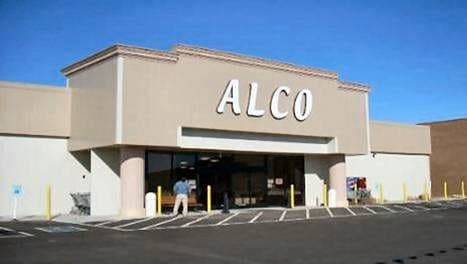

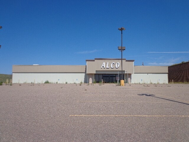
Property Detail
380 Dexter St
W001356
WRAY, UNPLATTED MISC TRACTS TR IN E 1/2 COMM AT INTERS N LN RR ST AND W LN CLAY ST; THN N 69 DEG 56'48"W 636.98' SAID POB; THN N 23 DEG 10'27"W 329.68', THN N 35 DEG 55'05"W 113.89' TO PT ON NONTANGENT CRV ON ARC OF CRV TO RHT, CENT BEARS N 65 DEG 53
Storebuilding
Yuma
2025
Colorado
2025
2.85 AC
963100
Colorado East Area
26,330 SF
Other Market Areas
NEARBY LISTINGS FOR SALE OR LEASE
-
-
View all Wray listings for lease on LoopNet.com
DEMOGRAPHICS near 380 Dexter St
1 mile
3 mile
5 mile
2025 Total Population
2,232
2,775
3,016
2030 Population
2,258
2,811
3,060
Pop Growth 2025-2030
+ 1.16%
+ 1.30%
+ 1.46%
Average Age
39
39
39
2025 Total Households
874
1,083
1,174
HH Growth 2025-2030
+ 1.49%
+ 1.57%
+ 1.70%
Median Household Inc
$60,870
$63,562
$66,768
Avg Household Size
2.50
2.50
2.50
2025 Avg HH Vehicles
2.00
2.00
2.00
Median Home Value
$229,829
$234,123
$238,789
Median Year Built
1955
1956
1957
Nearby Places
Map Layers
Map Styles
 Street
 Aerial
Layers
 Traffic
 Biking
Places
Listings with unknown addresses are not visible on the map
- Restaurants
- Banks
- Shops
- Fitness
- Groceries
SALE & LEASE HISTORY
LISTING DATE
SALE/LEASE

Sep 24, 2016
For Sale
May 31, 2017
For Lease
Nearby Properties
Address
Land Use
TOTAL SIZE
Lot Size
Zoning
Address
Land Use
TOTAL SIZE
Lot Size
Zoning
Address
Land Use
TOTAL SIZE
Lot Size
Zoning
152.84 AC
Address
Land Use
TOTAL SIZE
Lot Size
Zoning
1 SF
10 AC
Address
Land Use
TOTAL SIZE
Lot Size
Zoning
323.88 AC
Address
Land Use
TOTAL SIZE
Lot Size
Zoning
1 SF
28.17 AC
Address
Land Use
TOTAL SIZE
Lot Size
Zoning
1 SF
0.96 AC
Address
Land Use
TOTAL SIZE
Lot Size
Zoning
0.83 AC
Address
Land Use
TOTAL SIZE
Lot Size
Zoning
Address
Land Use
TOTAL SIZE
Lot Size
Zoning
1 SF
0.70 AC
Address
Land Use
TOTAL SIZE
Lot Size
Zoning
1 SF
0.83 AC
Address
Land Use
TOTAL SIZE
Lot Size
Zoning
0.12 AC
Address
Land Use
TOTAL SIZE
Lot Size
Zoning
0.77 AC
Address
Land Use
TOTAL SIZE
Lot Size
Zoning
1 SF
1.43 AC
Address
Land Use
TOTAL SIZE
Lot Size
Zoning
1.78 AC
Address
Land Use
TOTAL SIZE
Lot Size
Zoning
1 SF
0.93 AC
Address
Land Use
TOTAL SIZE
Lot Size
Zoning
Address
Land Use
TOTAL SIZE
Lot Size
Zoning
92,025 SF
5.99 AC
Address
Land Use
TOTAL SIZE
Lot Size
Zoning
0.48 AC
Address
Land Use
TOTAL SIZE
Lot Size
Zoning
1 SF
18.60 AC
Address
Land Use
TOTAL SIZE
Lot Size
Zoning
1 SF
2.53 AC
Address
Land Use
TOTAL SIZE
Lot Size
Zoning
18,768 SF
1.66 AC
Address
Land Use
TOTAL SIZE
Lot Size
Zoning
0.32 AC
Address
Land Use
TOTAL SIZE
Lot Size
Zoning
1 SF
0.16 AC
Address
Land Use
TOTAL SIZE
Lot Size
Zoning
9,707 SF
0.96 AC
Address
Land Use
TOTAL SIZE
Lot Size
Zoning
42,624 SF
2.85 AC
Address
Land Use
TOTAL SIZE
Lot Size
Zoning
1 SF
0.48 AC
Address
Land Use
TOTAL SIZE
Lot Size
Zoning
4,428 SF
0.30 AC
Address
Land Use
TOTAL SIZE
Lot Size
Zoning
2,484 SF
0.61 AC
Address
Land Use
TOTAL SIZE
Lot Size
Zoning
11,860 SF
0.96 AC
Address
Land Use
TOTAL SIZE
Lot Size
Zoning
0.96 AC
The World's #1 Commercial Real Estate Marketplace
Connect with us
© 2026 CoStar Group
The information above has been obtained from sources believed reliable. While we do not doubt its accuracy we have not verified it and make no guarantee, warranty or representation about it. It is your responsibility to independently confirm its accuracy and completeness. Any projections, opinions, assumptions, or estimates used are for example only and do not represent the current or future performance of the property. The value of this transaction to you depends on tax and other factors which should be evaluated by your tax, financial, and legal advisors. You and your advisors should conduct a careful, independent investigation of the property to determine to your satisfaction the suitability of the property for your needs.