Property Record
380 E 3090 S, Washington, UT 84780
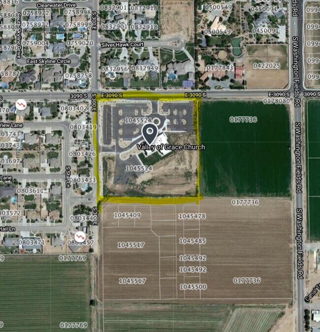

Property Detail
380 E 3090 S
1045524
SUBDIVISION: STAMSUND ESTATES SUBDIVISION PARTIAL AMENDMENT A (W) LOT: 14 FKA STAMSUND ESTATES SUBDIVISION
Taxexempt
Washington
B and X Area of moderate flood hazard, usually the area between the limits of the 100-year and 500-year floods.
Utah
0
14
2025
7.35 AC
270804
Other Market Areas
26,236 SF
St. George, UT
NEARBY LISTINGS FOR SALE OR LEASE
DEMOGRAPHICS near 380 E 3090 S
1 mile
3 mile
5 mile
2025 Total Population
6,070
41,683
90,395
2030 Population
6,737
45,829
99,441
Pop Growth 2025-2030
+ 10.99%
+ 9.95%
+ 10.01%
Average Age
35
38
39
2025 Total Households
1,617
13,013
30,182
HH Growth 2025-2030
+ 11.50%
+ 10.23%
+ 10.34%
Median Household Inc
$113,812
$93,889
$79,038
Avg Household Size
3.70
3.10
2.90
2025 Avg HH Vehicles
3.00
2.00
2.00
Median Home Value
$721,806
$627,871
$574,536
Median Year Built
2011
2009
2005
Nearby Places
Map Layers
Map Styles
 Street
 Aerial
Layers
 Traffic
 Biking
Places
Listings with unknown addresses are not visible on the map
- Restaurants
- Banks
- Shops
- Fitness
- Groceries
PUBLIC TRANSPORTATION
AIRPORT
St George Regional
Drive
Walk
Distance
St George Regional
20 min
8.8 mi
Nearby Properties
Address
Land Use
TOTAL SIZE
Lot Size
Zoning
Address
Land Use
TOTAL SIZE
Lot Size
Zoning
1,120,988 SF
52.22 AC
PDCOM
Address
Land Use
TOTAL SIZE
Lot Size
Zoning
230,880 SF
25.58 AC
C-2
Address
Land Use
TOTAL SIZE
Lot Size
Zoning
66,506 SF
15.12 AC
Address
Land Use
TOTAL SIZE
Lot Size
Zoning
97,572 SF
10.51 AC
PD
Address
Land Use
TOTAL SIZE
Lot Size
Zoning
88,445 SF
3.28 AC
C2
Address
Land Use
TOTAL SIZE
Lot Size
Zoning
86,875 SF
77.53 AC
Address
Land Use
TOTAL SIZE
Lot Size
Zoning
153,140 SF
17.17 AC
C-3
Address
Land Use
TOTAL SIZE
Lot Size
Zoning
120,219 SF
11.88 AC
Address
Land Use
TOTAL SIZE
Lot Size
Zoning
67,974 SF
7.04 AC
Address
Land Use
TOTAL SIZE
Lot Size
Zoning
76,907 SF
4 AC
PDCOM
Address
Land Use
TOTAL SIZE
Lot Size
Zoning
77,771 SF
6.02 AC
A1
Address
Land Use
TOTAL SIZE
Lot Size
Zoning
3,432 SF
57.26 AC
A20
Address
Land Use
TOTAL SIZE
Lot Size
Zoning
137,662 SF
7.81 AC
PD
Address
Land Use
TOTAL SIZE
Lot Size
Zoning
69,421 SF
5.73 AC
PDCOM
Address
Land Use
TOTAL SIZE
Lot Size
Zoning
56,572 SF
12 AC
Address
Land Use
TOTAL SIZE
Lot Size
Zoning
34,097 SF
5.90 AC
Address
Land Use
TOTAL SIZE
Lot Size
Zoning
125,208 SF
4.15 AC
PDCOM
Address
Land Use
TOTAL SIZE
Lot Size
Zoning
2,268 SF
49.03 AC
A20
Address
Land Use
TOTAL SIZE
Lot Size
Zoning
135,592 SF
11.24 AC
PDCOM
Address
Land Use
TOTAL SIZE
Lot Size
Zoning
111,865 SF
5 AC
M-2
Address
Land Use
TOTAL SIZE
Lot Size
Zoning
88,962 SF
8.35 AC
C-3
Address
Land Use
TOTAL SIZE
Lot Size
Zoning
54,754 SF
3.17 AC
AP
Address
Land Use
TOTAL SIZE
Lot Size
Zoning
115,050 SF
10.15 AC
C-2
Address
Land Use
TOTAL SIZE
Lot Size
Zoning
57,335 SF
4.53 AC
Address
Land Use
TOTAL SIZE
Lot Size
Zoning
31,955 SF
5.44 AC
C-2
Address
Land Use
TOTAL SIZE
Lot Size
Zoning
36,334 SF
5.78 AC
Address
Land Use
TOTAL SIZE
Lot Size
Zoning
40,272 SF
4.60 AC
Address
Land Use
TOTAL SIZE
Lot Size
Zoning
2,903 SF
37.45 AC
A20
Address
Land Use
TOTAL SIZE
Lot Size
Zoning
14,662 SF
31.24 AC
R110
The World's #1 Commercial Real Estate Marketplace
Connect with us
© 2026 CoStar Group
The information above has been obtained from sources believed reliable. While we do not doubt its accuracy we have not verified it and make no guarantee, warranty or representation about it. It is your responsibility to independently confirm its accuracy and completeness. Any projections, opinions, assumptions, or estimates used are for example only and do not represent the current or future performance of the property. The value of this transaction to you depends on tax and other factors which should be evaluated by your tax, financial, and legal advisors. You and your advisors should conduct a careful, independent investigation of the property to determine to your satisfaction the suitability of the property for your needs.